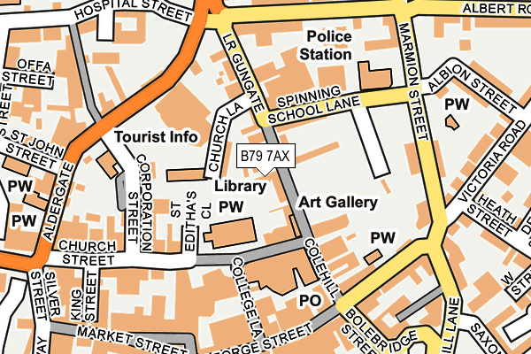
B79 7AX lies on Little Church Lane in Tamworth. B79 7AX is located in the Castle electoral ward, within the local authority district of Tamworth and the English Parliamentary constituency of Tamworth. The Sub Integrated Care Board (ICB) Location is NHS Staffordshire and Stoke-on-Trent ICB - 05Q and the police force is Staffordshire. This postcode has been in use since January 1980.


GetTheData
Source: OS OpenMap – Local (Ordnance Survey)
Source: OS VectorMap District (Ordnance Survey)
Licence: Open Government Licence (requires attribution)
| Easting | 420823 |
| Northing | 304162 |
| Latitude | 52.634830 |
| Longitude | -1.693746 |
GetTheData
Source: Open Postcode Geo
Licence: Open Government Licence
| Street | Little Church Lane |
| Town/City | Tamworth |
| Country | England |
| Postcode District | B79 |
➜ See where B79 is on a map ➜ Where is Tamworth? | |
GetTheData
Source: Land Registry Price Paid Data
Licence: Open Government Licence
Elevation or altitude of B79 7AX as distance above sea level:
| Metres | Feet | |
|---|---|---|
| Elevation | 70m | 230ft |
Elevation is measured from the approximate centre of the postcode, to the nearest point on an OS contour line from OS Terrain 50, which has contour spacing of ten vertical metres.
➜ How high above sea level am I? Find the elevation of your current position using your device's GPS.
GetTheData
Source: Open Postcode Elevation
Licence: Open Government Licence
| Ward | Castle |
| Constituency | Tamworth |
GetTheData
Source: ONS Postcode Database
Licence: Open Government Licence
| Bus Interchange (Corporation Street) | Tamworth Town Centre | 143m |
| Bus Interchange (Corporation Street) | Tamworth Town Centre | 150m |
| Arriva Bus Depot (Aldergate) | Tamworth Town Centre | 153m |
| Bus Interchange (Corporation Street) | Tamworth Town Centre | 156m |
| Bus Interchange (Corporation St) | Tamworth Town Centre | 164m |
| Tamworth Station | 0.6km |
| Tamworth High Level Station | 0.6km |
| Wilnecote (Staffs) Station | 2.8km |
GetTheData
Source: NaPTAN
Licence: Open Government Licence
| Percentage of properties with Next Generation Access | 100.0% |
| Percentage of properties with Superfast Broadband | 100.0% |
| Percentage of properties with Ultrafast Broadband | 100.0% |
| Percentage of properties with Full Fibre Broadband | 0.0% |
Superfast Broadband is between 30Mbps and 300Mbps
Ultrafast Broadband is > 300Mbps
| Percentage of properties unable to receive 2Mbps | 0.0% |
| Percentage of properties unable to receive 5Mbps | 0.0% |
| Percentage of properties unable to receive 10Mbps | 0.0% |
| Percentage of properties unable to receive 30Mbps | 0.0% |
GetTheData
Source: Ofcom
Licence: Ofcom Terms of Use (requires attribution)
GetTheData
Source: ONS Postcode Database
Licence: Open Government Licence


➜ Get more ratings from the Food Standards Agency
GetTheData
Source: Food Standards Agency
Licence: FSA terms & conditions
| Last Collection | |||
|---|---|---|---|
| Location | Mon-Fri | Sat | Distance |
| Tamworth P.o. | 18:45 | 12:30 | 106m |
| 2 Albert Road | 18:30 | 11:30 | 179m |
| Balfour | 18:30 | 11:30 | 410m |
GetTheData
Source: Dracos
Licence: Creative Commons Attribution-ShareAlike
The below table lists the International Territorial Level (ITL) codes (formerly Nomenclature of Territorial Units for Statistics (NUTS) codes) and Local Administrative Units (LAU) codes for B79 7AX:
| ITL 1 Code | Name |
|---|---|
| TLG | West Midlands (England) |
| ITL 2 Code | Name |
| TLG2 | Shropshire and Staffordshire |
| ITL 3 Code | Name |
| TLG24 | Staffordshire CC |
| LAU 1 Code | Name |
| E07000199 | Tamworth |
GetTheData
Source: ONS Postcode Directory
Licence: Open Government Licence
The below table lists the Census Output Area (OA), Lower Layer Super Output Area (LSOA), and Middle Layer Super Output Area (MSOA) for B79 7AX:
| Code | Name | |
|---|---|---|
| OA | E00152039 | |
| LSOA | E01029835 | Tamworth 002A |
| MSOA | E02006218 | Tamworth 002 |
GetTheData
Source: ONS Postcode Directory
Licence: Open Government Licence
| B79 7AL | Lower Gungate | 37m |
| B79 7BA | Lower Gungate | 41m |
| B79 7AU | Church Lane | 47m |
| B79 7AT | Lower Gungate | 55m |
| B79 7BX | Church Street | 78m |
| B79 7DE | Church Street | 146m |
| B79 7HE | Colehill | 147m |
| B79 7DL | Aldergate | 180m |
| B79 7DF | Church Street | 192m |
| B79 7JG | Marmion Street | 196m |
GetTheData
Source: Open Postcode Geo; Land Registry Price Paid Data
Licence: Open Government Licence