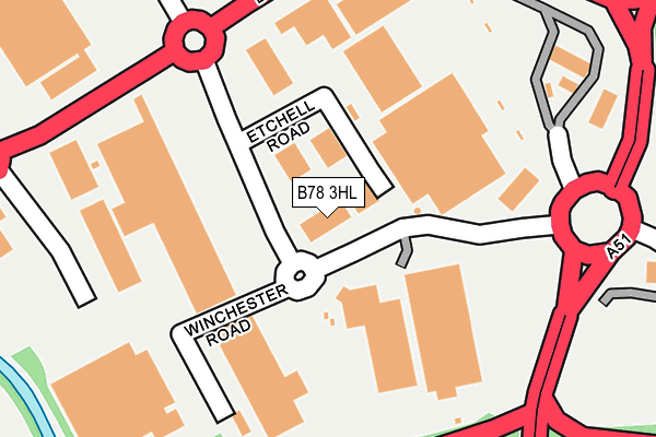
B78 3HL is located in the Castle electoral ward, within the local authority district of Tamworth and the English Parliamentary constituency of Tamworth. The Sub Integrated Care Board (ICB) Location is NHS Staffordshire and Stoke-on-Trent ICB - 05Q and the police force is Staffordshire. This postcode has been in use since June 1997.


GetTheData
Source: OS OpenMap – Local (Ordnance Survey)
Source: OS VectorMap District (Ordnance Survey)
Licence: Open Government Licence (requires attribution)
| Easting | 419870 |
| Northing | 303261 |
| Latitude | 52.626766 |
| Longitude | -1.707882 |
GetTheData
Source: Open Postcode Geo
Licence: Open Government Licence
| Country | England |
| Postcode District | B78 |
| ➜ B78 open data dashboard ➜ See where B78 is on a map ➜ Where is Tamworth? | |
GetTheData
Source: Land Registry Price Paid Data
Licence: Open Government Licence
Elevation or altitude of B78 3HL as distance above sea level:
| Metres | Feet | |
|---|---|---|
| Elevation | 60m | 197ft |
Elevation is measured from the approximate centre of the postcode, to the nearest point on an OS contour line from OS Terrain 50, which has contour spacing of ten vertical metres.
➜ How high above sea level am I? Find the elevation of your current position using your device's GPS.
GetTheData
Source: Open Postcode Elevation
Licence: Open Government Licence
| Ward | Castle |
| Constituency | Tamworth |
GetTheData
Source: ONS Postcode Database
Licence: Open Government Licence
| January 2024 | Shoplifting | On or near Ventura Park Road | 90m |
| January 2024 | Shoplifting | On or near Ventura Park Road | 90m |
| January 2024 | Shoplifting | On or near Ventura Park Road | 90m |
| ➜ Get more crime data in our Crime section | |||
GetTheData
Source: data.police.uk
Licence: Open Government Licence
| Sainsbury's Store (Ventura Park Road) | Ventura Park | 87m |
| Sainsbury's Store (Ventura Park Road) | Ventura Park | 95m |
| Etchell Road (Ventura Park Road) | Ventura Park | 122m |
| Etchell Road (Ventura Park Road) | Ventura Park | 149m |
| John Lewis (Ventura Park Road) | Ventura Park | 171m |
| Tamworth Station | 1.9km |
| Tamworth High Level Station | 1.9km |
| Wilnecote (Staffs) Station | 2.6km |
GetTheData
Source: NaPTAN
Licence: Open Government Licence
GetTheData
Source: ONS Postcode Database
Licence: Open Government Licence


➜ Get more ratings from the Food Standards Agency
GetTheData
Source: Food Standards Agency
Licence: FSA terms & conditions
| Last Collection | |||
|---|---|---|---|
| Location | Mon-Fri | Sat | Distance |
| Sainsburys | 17:00 | 11:00 | 175m |
| Balfour | 18:30 | 11:30 | 917m |
| Manor Road Mile Oak | 16:45 | 07:00 | 1,174m |
GetTheData
Source: Dracos
Licence: Creative Commons Attribution-ShareAlike
| Facility | Distance |
|---|---|
| Puregym (Tamworth) Bitterscote Drive, Bonehill, Tamworth Health and Fitness Gym, Studio | 113m |
| Bannatyne Health Club (Tamworth) Bonehill Road, Tamworth Swimming Pool, Health and Fitness Gym, Studio | 284m |
| The Gym Group (Tamworth) River Drive, Tamworth Health and Fitness Gym, Studio | 877m |
GetTheData
Source: Active Places
Licence: Open Government Licence
| School | Phase of Education | Distance |
|---|---|---|
| Moorgate Primary Academy Moorgate, Tamworth, B79 7EL | Primary | 1.3km |
| Kettlebrook Short Stay School Tame Street, Kettlebrook, Tamworth, B77 1AL | Not applicable | 1.3km |
| Mortimer House School Mortimer House, 17 Victoria Road, Tamworth, Staffordshire, B79 7HS | Not applicable | 1.6km |
GetTheData
Source: Edubase
Licence: Open Government Licence
| Risk of B78 3HL flooding from rivers and sea | Low |
| ➜ B78 3HL flood map | |
GetTheData
Source: Open Flood Risk by Postcode
Licence: Open Government Licence
The below table lists the International Territorial Level (ITL) codes (formerly Nomenclature of Territorial Units for Statistics (NUTS) codes) and Local Administrative Units (LAU) codes for B78 3HL:
| ITL 1 Code | Name |
|---|---|
| TLG | West Midlands (England) |
| ITL 2 Code | Name |
| TLG2 | Shropshire and Staffordshire |
| ITL 3 Code | Name |
| TLG24 | Staffordshire CC |
| LAU 1 Code | Name |
| E07000199 | Tamworth |
GetTheData
Source: ONS Postcode Directory
Licence: Open Government Licence
The below table lists the Census Output Area (OA), Lower Layer Super Output Area (LSOA), and Middle Layer Super Output Area (MSOA) for B78 3HL:
| Code | Name | |
|---|---|---|
| OA | E00152042 | |
| LSOA | E01029837 | Tamworth 005B |
| MSOA | E02006221 | Tamworth 005 |
GetTheData
Source: ONS Postcode Directory
Licence: Open Government Licence
| B78 3HJ | Bonehill Road | 352m |
| B78 3JE | High Broom Court | 542m |
| B78 3HE | Chippendale Place | 589m |
| B78 3XU | Hampshire Close | 604m |
| B78 3LR | Aitken Close | 605m |
| B78 3XS | Huntingdon Close | 618m |
| B78 3HQ | Bonehill Road | 637m |
| B78 3JJ | Fazeley Road | 651m |
| B78 3JZ | Sutton Avenue | 660m |
| B78 3JQ | Lakeview Avenue | 683m |
GetTheData
Source: Open Postcode Geo; Land Registry Price Paid Data
Licence: Open Government Licence