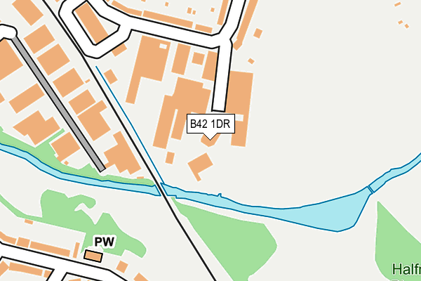
B42 1DR is located in the Perry Barr electoral ward, within the metropolitan district of Birmingham and the English Parliamentary constituency of Birmingham, Perry Barr. The Sub Integrated Care Board (ICB) Location is NHS Birmingham and Solihull ICB - 15E and the police force is West Midlands. This postcode has been in use since February 2008.


GetTheData
Source: OS OpenMap – Local (Ordnance Survey)
Source: OS VectorMap District (Ordnance Survey)
Licence: Open Government Licence (requires attribution)
| Easting | 405493 |
| Northing | 292043 |
| Latitude | 52.526249 |
| Longitude | -1.920461 |
GetTheData
Source: Open Postcode Geo
Licence: Open Government Licence
| Country | England |
| Postcode District | B42 |
| ➜ B42 open data dashboard ➜ See where B42 is on a map ➜ Where is Birmingham? | |
GetTheData
Source: Land Registry Price Paid Data
Licence: Open Government Licence
Elevation or altitude of B42 1DR as distance above sea level:
| Metres | Feet | |
|---|---|---|
| Elevation | 100m | 328ft |
Elevation is measured from the approximate centre of the postcode, to the nearest point on an OS contour line from OS Terrain 50, which has contour spacing of ten vertical metres.
➜ How high above sea level am I? Find the elevation of your current position using your device's GPS.
GetTheData
Source: Open Postcode Elevation
Licence: Open Government Licence
| Ward | Perry Barr |
| Constituency | Birmingham, Perry Barr |
GetTheData
Source: ONS Postcode Database
Licence: Open Government Licence
| June 2022 | Violence and sexual offences | On or near Lavendon Road | 231m |
| June 2022 | Vehicle crime | On or near Lavendon Road | 231m |
| June 2022 | Violence and sexual offences | On or near Lavendon Road | 231m |
| ➜ Get more crime data in our Crime section | |||
GetTheData
Source: data.police.uk
Licence: Open Government Licence
| Lavendon Rd (Rocky Lane) | Alexander Stadium | 388m |
| Lavendon Rd (Rocky Lane) | Alexander Stadium | 400m |
| Derrydown Rd (Rocky Lane) | Alexander Stadium | 410m |
| Derrydown Rd (Rocky Lane) | Alexander Stadium | 415m |
| Tower Hill (Rocky Lane) | Tower Hill | 563m |
| Hamstead (Birmingham) Station | 0.8km |
| Perry Barr Station | 1.7km |
| Witton (West Midlands) Station | 2.9km |
GetTheData
Source: NaPTAN
Licence: Open Government Licence
GetTheData
Source: ONS Postcode Database
Licence: Open Government Licence


➜ Get more ratings from the Food Standards Agency
GetTheData
Source: Food Standards Agency
Licence: FSA terms & conditions
| Last Collection | |||
|---|---|---|---|
| Location | Mon-Fri | Sat | Distance |
| Cherry Orchard Road / Lloyd Road | 17:45 | 12:30 | 271m |
| 126 Baltimore Road | 17:45 | 12:30 | 301m |
| Derrydown Road / Rocky Lane | 17:45 | 12:30 | 389m |
GetTheData
Source: Dracos
Licence: Creative Commons Attribution-ShareAlike
| Facility | Distance |
|---|---|
| Dorrington Academy Dorrington Road, Birmingham Artificial Grass Pitch | 434m |
| Perry Hall Playing Fields Perry Avenue, Birmingham Grass Pitches, Cycling | 529m |
| Hamstead Site Hamstead Hill, Birmingham Grass Pitches | 648m |
GetTheData
Source: Active Places
Licence: Open Government Licence
| School | Phase of Education | Distance |
|---|---|---|
| Dorrington Academy Dorrington Road, Perry Barr, Birmingham, B42 1QR | Primary | 434m |
| Cherry Orchard Primary School Cherry Orchard Road, Handsworth Wood, Birmingham, B20 2LB | Primary | 677m |
| St Teresa's Catholic Primary School Butlers Road, Handsworth Wood, Birmingham, B20 2NY | Primary | 1.1km |
GetTheData
Source: Edubase
Licence: Open Government Licence
| Risk of B42 1DR flooding from rivers and sea | Low |
| ➜ B42 1DR flood map | |
GetTheData
Source: Open Flood Risk by Postcode
Licence: Open Government Licence
The below table lists the International Territorial Level (ITL) codes (formerly Nomenclature of Territorial Units for Statistics (NUTS) codes) and Local Administrative Units (LAU) codes for B42 1DR:
| ITL 1 Code | Name |
|---|---|
| TLG | West Midlands (England) |
| ITL 2 Code | Name |
| TLG3 | West Midlands |
| ITL 3 Code | Name |
| TLG31 | Birmingham |
| LAU 1 Code | Name |
| E08000025 | Birmingham |
GetTheData
Source: ONS Postcode Directory
Licence: Open Government Licence
The below table lists the Census Output Area (OA), Lower Layer Super Output Area (LSOA), and Middle Layer Super Output Area (MSOA) for B42 1DR:
| Code | Name | |
|---|---|---|
| OA | E00046863 | |
| LSOA | E01009240 | Birmingham 024C |
| MSOA | E02001850 | Birmingham 024 |
GetTheData
Source: ONS Postcode Directory
Licence: Open Government Licence
| B42 1DD | Baltimore Road | 168m |
| B42 1QJ | Lavendon Road | 188m |
| B42 1QL | Baltimore Road | 229m |
| B42 1QG | Lavendon Road | 236m |
| B20 2JY | Cherry Orchard Road | 258m |
| B42 1QH | Whitburn Avenue | 265m |
| B42 1DU | Austin Way | 318m |
| B20 2NG | Cherry Orchard Road | 330m |
| B42 1QT | Dorrington Road | 331m |
| B20 2JZ | Cherry Orchard Road | 336m |
GetTheData
Source: Open Postcode Geo; Land Registry Price Paid Data
Licence: Open Government Licence