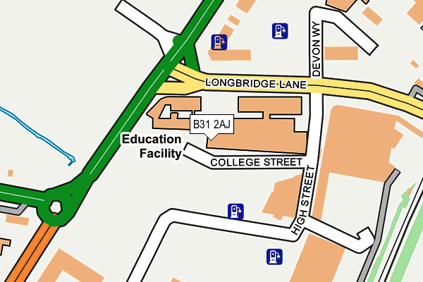
B31 2AJ is located in the Longbridge & West Heath electoral ward, within the metropolitan district of Birmingham and the English Parliamentary constituency of Birmingham, Northfield. The Sub Integrated Care Board (ICB) Location is NHS Birmingham and Solihull ICB - 15E and the police force is West Midlands. This postcode has been in use since January 1980.


GetTheData
Source: OS OpenMap – Local (Ordnance Survey)
Source: OS VectorMap District (Ordnance Survey)
Licence: Open Government Licence (requires attribution)
| Easting | 401018 |
| Northing | 277546 |
| Latitude | 52.395932 |
| Longitude | -1.986465 |
GetTheData
Source: Open Postcode Geo
Licence: Open Government Licence
| Country | England |
| Postcode District | B31 |
| ➜ B31 open data dashboard ➜ See where B31 is on a map ➜ Where is Birmingham? | |
GetTheData
Source: Land Registry Price Paid Data
Licence: Open Government Licence
Elevation or altitude of B31 2AJ as distance above sea level:
| Metres | Feet | |
|---|---|---|
| Elevation | 170m | 558ft |
Elevation is measured from the approximate centre of the postcode, to the nearest point on an OS contour line from OS Terrain 50, which has contour spacing of ten vertical metres.
➜ How high above sea level am I? Find the elevation of your current position using your device's GPS.
GetTheData
Source: Open Postcode Elevation
Licence: Open Government Licence
| Ward | Longbridge & West Heath |
| Constituency | Birmingham, Northfield |
GetTheData
Source: ONS Postcode Database
Licence: Open Government Licence
| January 2024 | Vehicle crime | On or near Cofton Court | 478m |
| January 2024 | Vehicle crime | On or near Cofton Court | 478m |
| January 2024 | Violence and sexual offences | On or near Cofton Court | 478m |
| ➜ Get more crime data in our Crime section | |||
GetTheData
Source: data.police.uk
Licence: Open Government Licence
| Bristol Road South (Longbridge Lane) | Longbridge | 111m |
| Longbridge Lane (Bristol Road South) | Longbridge | 123m |
| Bristol Road South (Longbridge Lane) | Longbridge | 134m |
| Longbridge Lane (Bristol Road South) | Longbridge | 181m |
| Longbridge Lane (Bristol Road South) | Longbridge | 242m |
| Longbridge Station | 0.4km |
| Northfield Station | 2km |
| Barnt Green Station | 3.9km |
GetTheData
Source: NaPTAN
Licence: Open Government Licence
GetTheData
Source: ONS Postcode Database
Licence: Open Government Licence


➜ Get more ratings from the Food Standards Agency
GetTheData
Source: Food Standards Agency
Licence: FSA terms & conditions
| Last Collection | |||
|---|---|---|---|
| Location | Mon-Fri | Sat | Distance |
| Longbridge | 17:30 | 12:30 | 228m |
| Sunbury Road Post Office | 17:30 | 12:30 | 480m |
| The Roundabout Off Bristol Road | 17:30 | 12:30 | 536m |
GetTheData
Source: Dracos
Licence: Creative Commons Attribution-ShareAlike
| Facility | Distance |
|---|---|
| Urban Fitness (Ecw) Bournville College Longbridge Lane, Birmingham Health and Fitness Gym, Sports Hall | 63m |
| Puregym (Birmingham Longbridge) High Street, High Street, Longbridge, Birmingham Health and Fitness Gym | 136m |
| The Factory Young People's Centre Devon Way, Birmingham Sports Hall, Studio | 212m |
GetTheData
Source: Active Places
Licence: Open Government Licence
| School | Phase of Education | Distance |
|---|---|---|
| St Columba's Catholic Primary School Lickey Road, Rednal, Birmingham, B45 8TD | Primary | 334m |
| The Meadows Primary School Bristol Road South, Northfield, Bristol Road South, Northfield, Birmingham, B31 2SW | Primary | 926m |
| Albert Bradbeer Primary Academy Turves Green, Longbridge, Birmingham, B31 4RD | Primary | 971m |
GetTheData
Source: Edubase
Licence: Open Government Licence
| Risk of B31 2AJ flooding from rivers and sea | Medium |
| ➜ B31 2AJ flood map | |
GetTheData
Source: Open Flood Risk by Postcode
Licence: Open Government Licence
The below table lists the International Territorial Level (ITL) codes (formerly Nomenclature of Territorial Units for Statistics (NUTS) codes) and Local Administrative Units (LAU) codes for B31 2AJ:
| ITL 1 Code | Name |
|---|---|
| TLG | West Midlands (England) |
| ITL 2 Code | Name |
| TLG3 | West Midlands |
| ITL 3 Code | Name |
| TLG31 | Birmingham |
| LAU 1 Code | Name |
| E08000025 | Birmingham |
GetTheData
Source: ONS Postcode Directory
Licence: Open Government Licence
The below table lists the Census Output Area (OA), Lower Layer Super Output Area (LSOA), and Middle Layer Super Output Area (MSOA) for B31 2AJ:
| Code | Name | |
|---|---|---|
| OA | E00046488 | |
| LSOA | E01009163 | Birmingham 129B |
| MSOA | E02001955 | Birmingham 129 |
GetTheData
Source: ONS Postcode Directory
Licence: Open Government Licence
| B31 2SU | Bristol Road South | 304m |
| B45 9TX | Bristol Road South | 332m |
| B31 2TW | Longbridge Lane | 356m |
| B31 4LP | Thurlestone Road | 364m |
| B31 2SQ | Kemshead Avenue | 384m |
| B31 2TD | Bristol Road South | 390m |
| B31 4LS | Thurlestone Road | 396m |
| B31 4LT | Falfield Grove | 396m |
| B31 2SG | Kemshead Avenue | 401m |
| B31 2SY | Broughton Crescent | 406m |
GetTheData
Source: Open Postcode Geo; Land Registry Price Paid Data
Licence: Open Government Licence