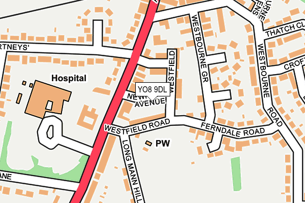
YO8 9DL lies on Newport Avenue in Selby. YO8 9DL is located in the Selby West electoral ward, within the unitary authority of North Yorkshire and the English Parliamentary constituency of Selby and Ainsty. The Sub Integrated Care Board (ICB) Location is NHS Humber and North Yorkshire ICB - 03Q and the police force is North Yorkshire. This postcode has been in use since January 1980.


GetTheData
Source: OS OpenMap – Local (Ordnance Survey)
Source: OS VectorMap District (Ordnance Survey)
Licence: Open Government Licence (requires attribution)
| Easting | 460939 |
| Northing | 431611 |
| Latitude | 53.777275 |
| Longitude | -1.076762 |
GetTheData
Source: Open Postcode Geo
Licence: Open Government Licence
| Street | Newport Avenue |
| Town/City | Selby |
| Country | England |
| Postcode District | YO8 |
➜ See where YO8 is on a map ➜ Where is Selby? | |
GetTheData
Source: Land Registry Price Paid Data
Licence: Open Government Licence
Elevation or altitude of YO8 9DL as distance above sea level:
| Metres | Feet | |
|---|---|---|
| Elevation | 10m | 33ft |
Elevation is measured from the approximate centre of the postcode, to the nearest point on an OS contour line from OS Terrain 50, which has contour spacing of ten vertical metres.
➜ How high above sea level am I? Find the elevation of your current position using your device's GPS.
GetTheData
Source: Open Postcode Elevation
Licence: Open Government Licence
| Ward | Selby West |
| Constituency | Selby And Ainsty |
GetTheData
Source: ONS Postcode Database
Licence: Open Government Licence
| Courtneys (Doncaster Road) | Selby | 69m |
| Newcroft (Courtneys) | Selby | 118m |
| Cournteys (Doncaster Road) | Selby | 118m |
| Newcroft (Courtneys) | Selby | 124m |
| 7 Hail And Ride End (Westbourne Road) | Selby | 154m |
| Selby Station | 1.1km |
GetTheData
Source: NaPTAN
Licence: Open Government Licence
| Percentage of properties with Next Generation Access | 100.0% |
| Percentage of properties with Superfast Broadband | 100.0% |
| Percentage of properties with Ultrafast Broadband | 0.0% |
| Percentage of properties with Full Fibre Broadband | 0.0% |
Superfast Broadband is between 30Mbps and 300Mbps
Ultrafast Broadband is > 300Mbps
| Median download speed | 40.0Mbps |
| Average download speed | 41.0Mbps |
| Maximum download speed | 80.00Mbps |
| Median upload speed | 10.0Mbps |
| Average upload speed | 9.5Mbps |
| Maximum upload speed | 20.00Mbps |
| Percentage of properties unable to receive 2Mbps | 0.0% |
| Percentage of properties unable to receive 5Mbps | 0.0% |
| Percentage of properties unable to receive 10Mbps | 0.0% |
| Percentage of properties unable to receive 30Mbps | 0.0% |
GetTheData
Source: Ofcom
Licence: Ofcom Terms of Use (requires attribution)
Estimated total energy consumption in YO8 9DL by fuel type, 2015.
| Consumption (kWh) | 317,016 |
|---|---|
| Meter count | 27 |
| Mean (kWh/meter) | 11,741 |
| Median (kWh/meter) | 9,255 |
| Consumption (kWh) | 55,128 |
|---|---|
| Meter count | 25 |
| Mean (kWh/meter) | 2,205 |
| Median (kWh/meter) | 2,175 |
GetTheData
Source: Postcode level gas estimates: 2015 (experimental)
Source: Postcode level electricity estimates: 2015 (experimental)
Licence: Open Government Licence
GetTheData
Source: ONS Postcode Database
Licence: Open Government Licence


➜ Get more ratings from the Food Standards Agency
GetTheData
Source: Food Standards Agency
Licence: FSA terms & conditions
| Last Collection | |||
|---|---|---|---|
| Location | Mon-Fri | Sat | Distance |
| Brayton Road Post Office | 17:30 | 12:00 | 210m |
| Green Lane | 16:30 | 12:00 | 217m |
| West End | 17:30 | 12:45 | 509m |
GetTheData
Source: Dracos
Licence: Creative Commons Attribution-ShareAlike
| Risk of YO8 9DL flooding from rivers and sea | Very Low |
| ➜ YO8 9DL flood map | |
GetTheData
Source: Open Flood Risk by Postcode
Licence: Open Government Licence
The below table lists the International Territorial Level (ITL) codes (formerly Nomenclature of Territorial Units for Statistics (NUTS) codes) and Local Administrative Units (LAU) codes for YO8 9DL:
| ITL 1 Code | Name |
|---|---|
| TLE | Yorkshire and The Humber |
| ITL 2 Code | Name |
| TLE2 | North Yorkshire |
| ITL 3 Code | Name |
| TLE22 | North Yorkshire CC |
| LAU 1 Code | Name |
| E07000169 | Selby |
GetTheData
Source: ONS Postcode Directory
Licence: Open Government Licence
The below table lists the Census Output Area (OA), Lower Layer Super Output Area (LSOA), and Middle Layer Super Output Area (MSOA) for YO8 9DL:
| Code | Name | |
|---|---|---|
| OA | E00142215 | |
| LSOA | E01027912 | Selby 006D |
| MSOA | E02005814 | Selby 006 |
GetTheData
Source: ONS Postcode Directory
Licence: Open Government Licence
| YO8 9DN | Westfield Road | 36m |
| YO8 9DJ | Westfield Avenue | 64m |
| YO8 9DH | Westfield | 64m |
| YO8 9BT | Doncaster Road | 73m |
| YO8 9QR | The Courtneys | 104m |
| YO8 9BX | Doncaster Road | 106m |
| YO8 9DG | Westbourne Grove | 153m |
| YO8 9DQ | Ferndale Road | 165m |
| YO8 9BU | Doncaster Road | 167m |
| YO8 9BY | Doncaster Road | 178m |
GetTheData
Source: Open Postcode Geo; Land Registry Price Paid Data
Licence: Open Government Licence