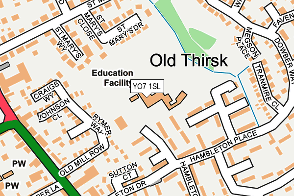
YO7 1SL is located in the Thirsk electoral ward, within the unitary authority of North Yorkshire and the English Parliamentary constituency of Thirsk and Malton. The Sub Integrated Care Board (ICB) Location is NHS Humber and North Yorkshire ICB - 42D and the police force is North Yorkshire. This postcode has been in use since January 1995.


GetTheData
Source: OS OpenMap – Local (Ordnance Survey)
Source: OS VectorMap District (Ordnance Survey)
Licence: Open Government Licence (requires attribution)
| Easting | 443380 |
| Northing | 482519 |
| Latitude | 54.236542 |
| Longitude | -1.335946 |
GetTheData
Source: Open Postcode Geo
Licence: Open Government Licence
| Country | England |
| Postcode District | YO7 |
| ➜ YO7 open data dashboard ➜ See where YO7 is on a map ➜ Where is Thirsk? | |
GetTheData
Source: Land Registry Price Paid Data
Licence: Open Government Licence
Elevation or altitude of YO7 1SL as distance above sea level:
| Metres | Feet | |
|---|---|---|
| Elevation | 40m | 131ft |
Elevation is measured from the approximate centre of the postcode, to the nearest point on an OS contour line from OS Terrain 50, which has contour spacing of ten vertical metres.
➜ How high above sea level am I? Find the elevation of your current position using your device's GPS.
GetTheData
Source: Open Postcode Elevation
Licence: Open Government Licence
| Ward | Thirsk |
| Constituency | Thirsk And Malton |
GetTheData
Source: ONS Postcode Database
Licence: Open Government Licence
| January 2024 | Other theft | On or near Hambleton View | 462m |
| October 2023 | Public order | On or near Hambleton View | 462m |
| October 2023 | Anti-social behaviour | On or near Hambleton View | 462m |
| ➜ Get more crime data in our Crime section | |||
GetTheData
Source: data.police.uk
Licence: Open Government Licence
| Hambleton Close (Hambleton Place) | Old Thirsk | 158m |
| Hambleton Close (Hambleton Drive) | Old Thirsk | 171m |
| Fairfield (St Marys Walk) | Old Thirsk | 228m |
| Tranmire Close (Hambleton Place) | Old Thirsk | 243m |
| Hambleton Drive (Long Street) | Old Thirsk | 245m |
| Thirsk Station | 2.6km |
GetTheData
Source: NaPTAN
Licence: Open Government Licence
GetTheData
Source: ONS Postcode Database
Licence: Open Government Licence


➜ Get more ratings from the Food Standards Agency
GetTheData
Source: Food Standards Agency
Licence: FSA terms & conditions
| Last Collection | |||
|---|---|---|---|
| Location | Mon-Fri | Sat | Distance |
| Frankland Arms Pub Ingramgate | 17:30 | 12:30 | 373m |
| Shire Road Thirsk | 17:45 | 12:15 | 520m |
| North Hill | 16:05 | 09:50 | 605m |
GetTheData
Source: Dracos
Licence: Creative Commons Attribution-ShareAlike
| Facility | Distance |
|---|---|
| East Thirsk Community Hall Hambleton Place, Thirsk Sports Hall | 74m |
| Thirsk And Sowerby Leisure Centre Chapel Street, Thirsk Swimming Pool, Health and Fitness Gym, Studio | 669m |
| Thirsk And Sowerby Flatts Chapel Street, Thirsk Grass Pitches | 731m |
GetTheData
Source: Active Places
Licence: Open Government Licence
| School | Phase of Education | Distance |
|---|---|---|
| Thirsk Community Primary School Hambleton Place, Thirsk, YO7 1SL | Primary | 13m |
| All Saints Catholic Primary School, a Catholic Voluntary Academy Green Lane East, Sowerby, Thirsk, YO7 1NB | Primary | 1.2km |
| Sowerby Primary Academy Topcliffe Road, Sowerby, Sowerby Primary Academy, Thirsk, YO7 1RX | Primary | 1.3km |
GetTheData
Source: Edubase
Licence: Open Government Licence
The below table lists the International Territorial Level (ITL) codes (formerly Nomenclature of Territorial Units for Statistics (NUTS) codes) and Local Administrative Units (LAU) codes for YO7 1SL:
| ITL 1 Code | Name |
|---|---|
| TLE | Yorkshire and The Humber |
| ITL 2 Code | Name |
| TLE2 | North Yorkshire |
| ITL 3 Code | Name |
| TLE22 | North Yorkshire CC |
| LAU 1 Code | Name |
| E07000164 | Hambleton |
GetTheData
Source: ONS Postcode Directory
Licence: Open Government Licence
The below table lists the Census Output Area (OA), Lower Layer Super Output Area (LSOA), and Middle Layer Super Output Area (MSOA) for YO7 1SL:
| Code | Name | |
|---|---|---|
| OA | E00140698 | |
| LSOA | E01027629 | Hambleton 009B |
| MSOA | E02005758 | Hambleton 009 |
GetTheData
Source: ONS Postcode Directory
Licence: Open Government Licence
| YO7 1DZ | Hambleton Place | 88m |
| YO7 1DY | Hambleton Place | 107m |
| YO7 1DT | Hambleton Place | 117m |
| YO7 1UE | The Orchard | 127m |
| YO7 1UB | Rymer Way | 139m |
| YO7 1DX | Hambleton Place | 152m |
| YO7 1EA | Hambleton Place | 158m |
| YO7 1ER | St Marys Close | 160m |
| YO7 1EX | Sutton Court | 175m |
| YO7 1BX | St Marys Drive | 175m |
GetTheData
Source: Open Postcode Geo; Land Registry Price Paid Data
Licence: Open Government Licence