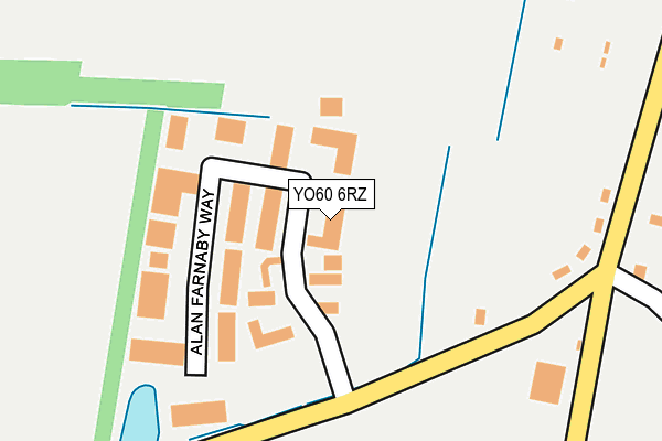
YO60 6RZ lies on Dale Road in Sheriff Hutton, York. YO60 6RZ is located in the Sheriff Hutton & Derwent electoral ward, within the unitary authority of North Yorkshire and the English Parliamentary constituency of Thirsk and Malton. The Sub Integrated Care Board (ICB) Location is NHS Humber and North Yorkshire ICB - 03Q and the police force is North Yorkshire. This postcode has been in use since June 1998.


GetTheData
Source: OS OpenMap – Local (Ordnance Survey)
Source: OS VectorMap District (Ordnance Survey)
Licence: Open Government Licence (requires attribution)
| Easting | 464385 |
| Northing | 465764 |
| Latitude | 54.083792 |
| Longitude | -1.017307 |
GetTheData
Source: Open Postcode Geo
Licence: Open Government Licence
| Street | Dale Road |
| Locality | Sheriff Hutton |
| Town/City | York |
| Country | England |
| Postcode District | YO60 |
| ➜ YO60 open data dashboard ➜ See where YO60 is on a map ➜ Where is Sheriff Hutton? | |
GetTheData
Source: Land Registry Price Paid Data
Licence: Open Government Licence
Elevation or altitude of YO60 6RZ as distance above sea level:
| Metres | Feet | |
|---|---|---|
| Elevation | 50m | 164ft |
Elevation is measured from the approximate centre of the postcode, to the nearest point on an OS contour line from OS Terrain 50, which has contour spacing of ten vertical metres.
➜ How high above sea level am I? Find the elevation of your current position using your device's GPS.
GetTheData
Source: Open Postcode Elevation
Licence: Open Government Licence
| Ward | Sheriff Hutton & Derwent |
| Constituency | Thirsk And Malton |
GetTheData
Source: ONS Postcode Database
Licence: Open Government Licence
| June 2022 | Public order | On or near Alan Farnaby Way | 74m |
| May 2022 | Bicycle theft | On or near Alan Farnaby Way | 74m |
| September 2021 | Anti-social behaviour | On or near Alan Farnaby Way | 74m |
| ➜ Get more crime data in our Crime section | |||
GetTheData
Source: data.police.uk
Licence: Open Government Licence
| Goose Track Lane | Lilling | 682m |
| Goose Track Lane | Lilling | 684m |
| Main Street | Sheriff Hutton | 929m |
| Main Street | Sheriff Hutton | 940m |
| Cobble Lane (Coble Lane) | Church End | 1,192m |
GetTheData
Source: NaPTAN
Licence: Open Government Licence
| Median download speed | 40.0Mbps |
| Average download speed | 49.8Mbps |
| Maximum download speed | 80.00Mbps |
| Median upload speed | 10.0Mbps |
| Average upload speed | 10.6Mbps |
| Maximum upload speed | 20.00Mbps |
GetTheData
Source: Ofcom
Licence: Ofcom Terms of Use (requires attribution)
GetTheData
Source: ONS Postcode Database
Licence: Open Government Licence


➜ Get more ratings from the Food Standards Agency
GetTheData
Source: Food Standards Agency
Licence: FSA terms & conditions
| Last Collection | |||
|---|---|---|---|
| Location | Mon-Fri | Sat | Distance |
| West Lilling | 16:15 | 11:00 | 760m |
| Sheriff Hutton Post Office | 16:30 | 11:00 | 942m |
| East End Sheriff Hutton | 16:30 | 10:45 | 1,267m |
GetTheData
Source: Dracos
Licence: Creative Commons Attribution-ShareAlike
| Facility | Distance |
|---|---|
| Sheriff Hutton Playing Fields Finkle Street, Sheriff Hutton Grass Pitches | 620m |
| Sherriff Hutton Bridge Cricket Club Strensall To Sheriff Hutton Road, Sheriff Hutton Grass Pitches | 1.6km |
| Terrington Village Hall And Recreation Ground Mowthorpe Lane, Terrington, York Sports Hall, Outdoor Tennis Courts, Grass Pitches | 5.5km |
GetTheData
Source: Active Places
Licence: Open Government Licence
| School | Phase of Education | Distance |
|---|---|---|
| Sheriff Hutton Primary School West End, Sheriff Hutton, York, YO60 6SH | Primary | 787m |
| Foston Church of England Voluntary Controlled Primary School Main Street, Foston, York, YO60 7QB | Primary | 4.3km |
| Terrington Church of England Voluntary Aided Primary School North Back Lane, Terrington, York, YO60 6NS | Primary | 5.6km |
GetTheData
Source: Edubase
Licence: Open Government Licence
The below table lists the International Territorial Level (ITL) codes (formerly Nomenclature of Territorial Units for Statistics (NUTS) codes) and Local Administrative Units (LAU) codes for YO60 6RZ:
| ITL 1 Code | Name |
|---|---|
| TLE | Yorkshire and The Humber |
| ITL 2 Code | Name |
| TLE2 | North Yorkshire |
| ITL 3 Code | Name |
| TLE22 | North Yorkshire CC |
| LAU 1 Code | Name |
| E07000167 | Ryedale |
GetTheData
Source: ONS Postcode Directory
Licence: Open Government Licence
The below table lists the Census Output Area (OA), Lower Layer Super Output Area (LSOA), and Middle Layer Super Output Area (MSOA) for YO60 6RZ:
| Code | Name | |
|---|---|---|
| OA | E00141604 | |
| LSOA | E01027799 | Ryedale 007E |
| MSOA | E02005794 | Ryedale 007 |
GetTheData
Source: ONS Postcode Directory
Licence: Open Government Licence
| YO60 6QH | Council Houses | 301m |
| YO60 6QP | York Road | 396m |
| YO60 6RQ | York Road | 509m |
| YO60 6RR | 541m | |
| YO60 6RG | York Road | 560m |
| YO60 6RF | Castle Side | 607m |
| YO60 6SW | Old Mill View | 620m |
| YO60 6SL | Mill Lane Avenue | 686m |
| YO60 6RE | Castle Side | 692m |
| YO60 6SJ | Mill Lane Avenue | 715m |
GetTheData
Source: Open Postcode Geo; Land Registry Price Paid Data
Licence: Open Government Licence