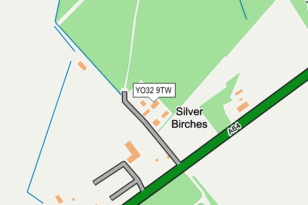
YO32 9TW lies on Malton Road in York. YO32 9TW is located in the Strensall electoral ward, within the unitary authority of York and the English Parliamentary constituency of York Outer. The Sub Integrated Care Board (ICB) Location is NHS Humber and North Yorkshire ICB - 03Q and the police force is North Yorkshire. This postcode has been in use since June 1998.


GetTheData
Source: OS OpenMap – Local (Ordnance Survey)
Source: OS VectorMap District (Ordnance Survey)
Licence: Open Government Licence (requires attribution)
| Easting | 466638 |
| Northing | 458341 |
| Latitude | 54.016785 |
| Longitude | -0.984490 |
GetTheData
Source: Open Postcode Geo
Licence: Open Government Licence
| Street | Malton Road |
| Town/City | York |
| Country | England |
| Postcode District | YO32 |
| ➜ YO32 open data dashboard ➜ See where YO32 is on a map | |
GetTheData
Source: Land Registry Price Paid Data
Licence: Open Government Licence
Elevation or altitude of YO32 9TW as distance above sea level:
| Metres | Feet | |
|---|---|---|
| Elevation | 20m | 66ft |
Elevation is measured from the approximate centre of the postcode, to the nearest point on an OS contour line from OS Terrain 50, which has contour spacing of ten vertical metres.
➜ How high above sea level am I? Find the elevation of your current position using your device's GPS.
GetTheData
Source: Open Postcode Elevation
Licence: Open Government Licence
| Ward | Strensall |
| Constituency | York Outer |
GetTheData
Source: ONS Postcode Database
Licence: Open Government Licence
| The Four Alls (A64) | Hazelbush | 239m |
| The Four Alls (A64) | Hazelbush | 297m |
| Hazelbush Farm (Common Lane) | Hazelbush | 598m |
| Hazelbush Farm (Common Lane) | Hazelbush | 601m |
| Fera (A64) | Hazelbush | 872m |
GetTheData
Source: NaPTAN
Licence: Open Government Licence
| Percentage of properties with Next Generation Access | 0.0% |
| Percentage of properties with Superfast Broadband | 0.0% |
| Percentage of properties with Ultrafast Broadband | 0.0% |
| Percentage of properties with Full Fibre Broadband | 0.0% |
Superfast Broadband is between 30Mbps and 300Mbps
Ultrafast Broadband is > 300Mbps
| Median download speed | 4.6Mbps |
| Average download speed | 5.0Mbps |
| Maximum download speed | 9.10Mbps |
| Median upload speed | 1.0Mbps |
| Average upload speed | 0.8Mbps |
| Maximum upload speed | 1.27Mbps |
| Percentage of properties unable to receive 2Mbps | 0.0% |
| Percentage of properties unable to receive 5Mbps | 83.3% |
| Percentage of properties unable to receive 10Mbps | 100.0% |
| Percentage of properties unable to receive 30Mbps | 100.0% |
GetTheData
Source: Ofcom
Licence: Ofcom Terms of Use (requires attribution)
Estimated total energy consumption in YO32 9TW by fuel type, 2015.
| Consumption (kWh) | 38,719 |
|---|---|
| Meter count | 11 |
| Mean (kWh/meter) | 3,520 |
| Median (kWh/meter) | 2,968 |
GetTheData
Source: Postcode level gas estimates: 2015 (experimental)
Source: Postcode level electricity estimates: 2015 (experimental)
Licence: Open Government Licence
GetTheData
Source: ONS Postcode Database
Licence: Open Government Licence


➜ Get more ratings from the Food Standards Agency
GetTheData
Source: Food Standards Agency
Licence: FSA terms & conditions
| Last Collection | |||
|---|---|---|---|
| Location | Mon-Fri | Sat | Distance |
| Off Malton Road Hazelbush | 17:30 | 11:30 | 601m |
| Station Road Stockton On Forest | 16:00 | 11:45 | 1,721m |
| Stockton On Forest Post Office | 16:00 | 11:45 | 2,871m |
GetTheData
Source: Dracos
Licence: Creative Commons Attribution-ShareAlike
| Facility | Distance |
|---|---|
| The National Agri-food Innovation Campus Sand Hutton To Black Dike Plantation, Sand Hutton, Malton Health and Fitness Gym, Studio | 855m |
| York Golf Range Towthorpe Lane, Towthorpe, York Golf | 2.2km |
| Sandburn Hall Golf Club Flaxton, York Golf, Sports Hall | 2.9km |
GetTheData
Source: Active Places
Licence: Open Government Licence
| School | Phase of Education | Distance |
|---|---|---|
| Stockton-on-the-Forest Primary School The Village, Stockton-on-the-Forest, York, YO32 9UP | Primary | 2.3km |
| Warthill Church of England Voluntary Controlled Primary School Warthill, York, YO19 5XL | Primary | 3km |
| Sand Hutton Church of England Voluntary Controlled Primary School Sand Hutton, York, YO41 1LB | Primary | 3.1km |
GetTheData
Source: Edubase
Licence: Open Government Licence
The below table lists the International Territorial Level (ITL) codes (formerly Nomenclature of Territorial Units for Statistics (NUTS) codes) and Local Administrative Units (LAU) codes for YO32 9TW:
| ITL 1 Code | Name |
|---|---|
| TLE | Yorkshire and The Humber |
| ITL 2 Code | Name |
| TLE2 | North Yorkshire |
| ITL 3 Code | Name |
| TLE21 | York |
| LAU 1 Code | Name |
| E06000014 | York |
GetTheData
Source: ONS Postcode Directory
Licence: Open Government Licence
The below table lists the Census Output Area (OA), Lower Layer Super Output Area (LSOA), and Middle Layer Super Output Area (MSOA) for YO32 9TW:
| Code | Name | |
|---|---|---|
| OA | E00067836 | |
| LSOA | E01013437 | York 008G |
| MSOA | E02002779 | York 008 |
GetTheData
Source: ONS Postcode Directory
Licence: Open Government Licence
| YO41 1LN | 1401m | |
| YO32 9UT | Sandy Lane | 1497m |
| YO32 9UU | Sandy Lane | 1574m |
| YO19 5XS | 1690m | |
| YO32 9TL | Malton Road | 1816m |
| YO32 9US | Sandy Lane | 1951m |
| YO32 9UR | Sandy Lane | 1955m |
| YO60 7RE | 2041m | |
| YO32 9WB | Sandy Lane | 2163m |
| YO32 9YU | Holly Tree Garth | 2246m |
GetTheData
Source: Open Postcode Geo; Land Registry Price Paid Data
Licence: Open Government Licence