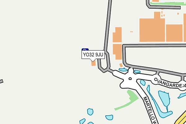
YO32 9JU is located in the Huntington & New Earswick electoral ward, within the unitary authority of York and the English Parliamentary constituency of York Outer. The Sub Integrated Care Board (ICB) Location is NHS Humber and North Yorkshire ICB - 03Q and the police force is North Yorkshire. This postcode has been in use since July 2004.


GetTheData
Source: OS OpenMap – Local (Ordnance Survey)
Source: OS VectorMap District (Ordnance Survey)
Licence: Open Government Licence (requires attribution)
| Easting | 462248 |
| Northing | 454473 |
| Latitude | 53.982573 |
| Longitude | -1.052267 |
GetTheData
Source: Open Postcode Geo
Licence: Open Government Licence
| Country | England |
| Postcode District | YO32 |
| ➜ YO32 open data dashboard ➜ See where YO32 is on a map ➜ Where is Huntington? | |
GetTheData
Source: Land Registry Price Paid Data
Licence: Open Government Licence
Elevation or altitude of YO32 9JU as distance above sea level:
| Metres | Feet | |
|---|---|---|
| Elevation | 10m | 33ft |
Elevation is measured from the approximate centre of the postcode, to the nearest point on an OS contour line from OS Terrain 50, which has contour spacing of ten vertical metres.
➜ How high above sea level am I? Find the elevation of your current position using your device's GPS.
GetTheData
Source: Open Postcode Elevation
Licence: Open Government Licence
| Ward | Huntington & New Earswick |
| Constituency | York Outer |
GetTheData
Source: ONS Postcode Database
Licence: Open Government Licence
| June 2022 | Criminal damage and arson | On or near Sports/Recreation Area | 260m |
| June 2022 | Shoplifting | On or near Kathryn Avenue | 275m |
| June 2022 | Other theft | On or near Kathryn Avenue | 275m |
| ➜ Get more crime data in our Crime section | |||
GetTheData
Source: data.police.uk
Licence: Open Government Licence
| Monks Cross Park And Ride (Martello Way) | Monks Cross | 18m |
| Monks Cross Park And Ride (Martello Way) | Monks Cross | 54m |
| Vangarde Shopping Centre (Vangarde Way) | Monks Cross | 257m |
| Kathryn Avenue (Jockey Lane) | Monks Cross | 373m |
| Kathryn Avenue (Jockey Lane) | Monks Cross | 408m |
| York Station | 3.8km |
GetTheData
Source: NaPTAN
Licence: Open Government Licence
GetTheData
Source: ONS Postcode Database
Licence: Open Government Licence


➜ Get more ratings from the Food Standards Agency
GetTheData
Source: Food Standards Agency
Licence: FSA terms & conditions
| Last Collection | |||
|---|---|---|---|
| Location | Mon-Fri | Sat | Distance |
| Monks Cross | 17:45 | 11:30 | 567m |
| Sainsburys Lay-by Monks Cross | 17:45 | 11:30 | 568m |
| Geldof Road | 17:30 | 12:30 | 589m |
GetTheData
Source: Dracos
Licence: Creative Commons Attribution-ShareAlike
| Facility | Distance |
|---|---|
| Lner Community Stadium Kathryn Avenue, Huntington, York Grass Pitches | 216m |
| York Stadium Leisure Complex Kathryn Avenue, Huntington, York Artificial Grass Pitch, Swimming Pool, Health and Fitness Gym, Studio, Sports Hall | 268m |
| York Community Fitness And Waterworld (Closed) Kathryn Avenue, Huntington, York Athletics, Swimming Pool, Health and Fitness Gym, Studio | 273m |
GetTheData
Source: Active Places
Licence: Open Government Licence
| School | Phase of Education | Distance |
|---|---|---|
| Yearsley Grove Primary School Yearsley Grove, Huntington, York, YO31 9BX | Primary | 804m |
| Huntington School Huntington Road, Huntington, York, YO32 9WT | Secondary | 1.2km |
| Huntington Primary Academy North Moor Road, Huntington, York, YO32 9QT | Primary | 1.4km |
GetTheData
Source: Edubase
Licence: Open Government Licence
The below table lists the International Territorial Level (ITL) codes (formerly Nomenclature of Territorial Units for Statistics (NUTS) codes) and Local Administrative Units (LAU) codes for YO32 9JU:
| ITL 1 Code | Name |
|---|---|
| TLE | Yorkshire and The Humber |
| ITL 2 Code | Name |
| TLE2 | North Yorkshire |
| ITL 3 Code | Name |
| TLE21 | York |
| LAU 1 Code | Name |
| E06000014 | York |
GetTheData
Source: ONS Postcode Directory
Licence: Open Government Licence
The below table lists the Census Output Area (OA), Lower Layer Super Output Area (LSOA), and Middle Layer Super Output Area (MSOA) for YO32 9JU:
| Code | Name | |
|---|---|---|
| OA | E00067684 | |
| LSOA | E01013409 | York 005C |
| MSOA | E02002776 | York 005 |
GetTheData
Source: ONS Postcode Directory
Licence: Open Government Licence
| YO32 9TD | Malton Road | 356m |
| YO32 9LX | Forge Close | 413m |
| YO32 9TE | Malton Road | 439m |
| YO32 9TB | New Lane | 464m |
| YO32 9LY | New Lane | 466m |
| YO32 9NA | New Lane | 478m |
| YO32 9LZ | New Lane | 481m |
| YO32 9PS | New Lane | 515m |
| YO32 9YG | Ferguson Way | 523m |
| YO31 9DH | Sherwood Grove | 527m |
GetTheData
Source: Open Postcode Geo; Land Registry Price Paid Data
Licence: Open Government Licence