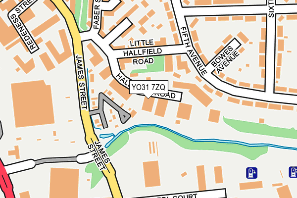
YO31 7ZQ is located in the Heworth electoral ward, within the unitary authority of York and the English Parliamentary constituency of York Central. The Sub Integrated Care Board (ICB) Location is NHS Humber and North Yorkshire ICB - 03Q and the police force is North Yorkshire. This postcode has been in use since June 1998.


GetTheData
Source: OS OpenMap – Local (Ordnance Survey)
Source: OS VectorMap District (Ordnance Survey)
Licence: Open Government Licence (requires attribution)
| Easting | 461304 |
| Northing | 452032 |
| Latitude | 53.960749 |
| Longitude | -1.067150 |
GetTheData
Source: Open Postcode Geo
Licence: Open Government Licence
| Country | England |
| Postcode District | YO31 |
➜ See where YO31 is on a map ➜ Where is York? | |
GetTheData
Source: Land Registry Price Paid Data
Licence: Open Government Licence
Elevation or altitude of YO31 7ZQ as distance above sea level:
| Metres | Feet | |
|---|---|---|
| Elevation | 10m | 33ft |
Elevation is measured from the approximate centre of the postcode, to the nearest point on an OS contour line from OS Terrain 50, which has contour spacing of ten vertical metres.
➜ How high above sea level am I? Find the elevation of your current position using your device's GPS.
GetTheData
Source: Open Postcode Elevation
Licence: Open Government Licence
| Ward | Heworth |
| Constituency | York Central |
GetTheData
Source: ONS Postcode Database
Licence: Open Government Licence
| Morrison's (Foss Islands Road) | Foss Islands | 196m |
| Glenside Flats (Fourth Avenue) | Tang Hall | 206m |
| Morrison's (Foss Islands Road) | Foss Islands | 216m |
| Glenside Flats (Fourth Avenue) | Tang Hall | 237m |
| Glen Avenue (Fifth Avenue) | Heworth | 361m |
| York Station | 1.7km |
GetTheData
Source: NaPTAN
Licence: Open Government Licence
GetTheData
Source: ONS Postcode Database
Licence: Open Government Licence

➜ Get more ratings from the Food Standards Agency
GetTheData
Source: Food Standards Agency
Licence: FSA terms & conditions
| Last Collection | |||
|---|---|---|---|
| Location | Mon-Fri | Sat | Distance |
| Hallfield Road York | 17:45 | 12:45 | 318m |
| Hallfield Road Heworth | 17:45 | 12:45 | 320m |
| Fourth Avenue | 17:45 | 12:15 | 455m |
GetTheData
Source: Dracos
Licence: Creative Commons Attribution-ShareAlike
| Risk of YO31 7ZQ flooding from rivers and sea | Low |
| ➜ YO31 7ZQ flood map | |
GetTheData
Source: Open Flood Risk by Postcode
Licence: Open Government Licence
The below table lists the International Territorial Level (ITL) codes (formerly Nomenclature of Territorial Units for Statistics (NUTS) codes) and Local Administrative Units (LAU) codes for YO31 7ZQ:
| ITL 1 Code | Name |
|---|---|
| TLE | Yorkshire and The Humber |
| ITL 2 Code | Name |
| TLE2 | North Yorkshire |
| ITL 3 Code | Name |
| TLE21 | York |
| LAU 1 Code | Name |
| E06000014 | York |
GetTheData
Source: ONS Postcode Directory
Licence: Open Government Licence
The below table lists the Census Output Area (OA), Lower Layer Super Output Area (LSOA), and Middle Layer Super Output Area (MSOA) for YO31 7ZQ:
| Code | Name | |
|---|---|---|
| OA | E00067557 | |
| LSOA | E01013383 | York 010D |
| MSOA | E02002781 | York 010 |
GetTheData
Source: ONS Postcode Directory
Licence: Open Government Licence
| YO31 7XP | Little Hallfield Road | 102m |
| YO31 7UH | Little Hallfield Road | 111m |
| YO31 7XW | Millennium Court | 122m |
| YO31 0UP | Fifth Avenue | 148m |
| YO31 7XL | Richmond Street | 152m |
| YO31 0XA | Fifth Avenue | 173m |
| YO31 0UZ | Bowes Avenue | 182m |
| YO31 7XQ | Hallfield Road | 187m |
| YO31 0UY | Fourth Avenue | 220m |
| YO31 7XH | Faber Street | 228m |
GetTheData
Source: Open Postcode Geo; Land Registry Price Paid Data
Licence: Open Government Licence