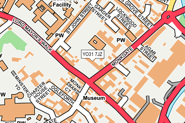
YO31 7JZ is located in the Guildhall electoral ward, within the unitary authority of York and the English Parliamentary constituency of York Central. The Sub Integrated Care Board (ICB) Location is NHS Humber and North Yorkshire ICB - 03Q and the police force is North Yorkshire. This postcode has been in use since December 2000.


GetTheData
Source: OS OpenMap – Local (Ordnance Survey)
Source: OS VectorMap District (Ordnance Survey)
Licence: Open Government Licence (requires attribution)
| Easting | 460590 |
| Northing | 452340 |
| Latitude | 53.963601 |
| Longitude | -1.077970 |
GetTheData
Source: Open Postcode Geo
Licence: Open Government Licence
| Country | England |
| Postcode District | YO31 |
| ➜ YO31 open data dashboard ➜ See where YO31 is on a map ➜ Where is York? | |
GetTheData
Source: Land Registry Price Paid Data
Licence: Open Government Licence
Elevation or altitude of YO31 7JZ as distance above sea level:
| Metres | Feet | |
|---|---|---|
| Elevation | 10m | 33ft |
Elevation is measured from the approximate centre of the postcode, to the nearest point on an OS contour line from OS Terrain 50, which has contour spacing of ten vertical metres.
➜ How high above sea level am I? Find the elevation of your current position using your device's GPS.
GetTheData
Source: Open Postcode Elevation
Licence: Open Government Licence
| Ward | Guildhall |
| Constituency | York Central |
GetTheData
Source: ONS Postcode Database
Licence: Open Government Licence
| January 2024 | Violence and sexual offences | On or near Bowling Green Lane | 313m |
| January 2024 | Bicycle theft | On or near Granary Court | 322m |
| January 2024 | Shoplifting | On or near Granary Court | 322m |
| ➜ Get more crime data in our Crime section | |||
GetTheData
Source: data.police.uk
Licence: Open Government Licence
| Monk Bar (Monkgate) | York | 36m |
| Lord Mayor's Walk | York | 85m |
| Trinity Methodist Church (Monkgate) | York | 153m |
| Penley's Grove Street | The Groves | 269m |
| Foss Bank Coach Stop (Foss Bank) | York | 270m |
| York Station | 1.2km |
| Poppleton Station | 4.8km |
GetTheData
Source: NaPTAN
Licence: Open Government Licence
GetTheData
Source: ONS Postcode Database
Licence: Open Government Licence


➜ Get more ratings from the Food Standards Agency
GetTheData
Source: Food Standards Agency
Licence: FSA terms & conditions
| Last Collection | |||
|---|---|---|---|
| Location | Mon-Fri | Sat | Distance |
| Monkgate | 17:30 | 12:00 | 207m |
| 4 Minster Yard | 18:45 | 12:45 | 228m |
| Penleys Grove Street | 17:45 | 12:15 | 277m |
GetTheData
Source: Dracos
Licence: Creative Commons Attribution-ShareAlike
| Facility | Distance |
|---|---|
| York St John University Sports Complex Lord Mayors Walk, York Sports Hall, Health and Fitness Gym, Studio | 173m |
| Ultraflex York Layerthorpe, Layerthorpe, York Health and Fitness Gym | 432m |
| The Gym Group (York Foss Island) Foss Islands Road, Foss Islands Road, York Health and Fitness Gym | 522m |
GetTheData
Source: Active Places
Licence: Open Government Licence
| School | Phase of Education | Distance |
|---|---|---|
| St Wilfrid's Catholic Primary School - a Catholic Voluntary Academy Monkgate, York, YO31 7PB | Primary | 59m |
| York St John University Lord Mayor's Walk, York, YO31 7EX | Not applicable | 173m |
| Park Grove Primary Academy Park Grove, York, YO31 8LG | Primary | 438m |
GetTheData
Source: Edubase
Licence: Open Government Licence
The below table lists the International Territorial Level (ITL) codes (formerly Nomenclature of Territorial Units for Statistics (NUTS) codes) and Local Administrative Units (LAU) codes for YO31 7JZ:
| ITL 1 Code | Name |
|---|---|
| TLE | Yorkshire and The Humber |
| ITL 2 Code | Name |
| TLE2 | North Yorkshire |
| ITL 3 Code | Name |
| TLE21 | York |
| LAU 1 Code | Name |
| E06000014 | York |
GetTheData
Source: ONS Postcode Directory
Licence: Open Government Licence
The below table lists the Census Output Area (OA), Lower Layer Super Output Area (LSOA), and Middle Layer Super Output Area (MSOA) for YO31 7JZ:
| Code | Name | |
|---|---|---|
| OA | E00067487 | |
| LSOA | E01013369 | York 013C |
| MSOA | E02002784 | York 013 |
GetTheData
Source: ONS Postcode Directory
Licence: Open Government Licence
| YO31 7UQ | St Wilfrids Court | 24m |
| YO31 7RD | High Newbiggin Street | 56m |
| YO31 7PD | Monkgate | 86m |
| YO31 7HA | Lord Mayors Walk | 89m |
| YO31 7QS | High Newbiggin Street | 93m |
| YO1 7LH | Monk Bar Court | 100m |
| YO31 7HY | Monkgate Cloisters | 101m |
| YO1 7LQ | Goodramgate | 117m |
| YO1 7JW | Ogleforth Mews | 122m |
| YO31 7QR | St John Street | 125m |
GetTheData
Source: Open Postcode Geo; Land Registry Price Paid Data
Licence: Open Government Licence