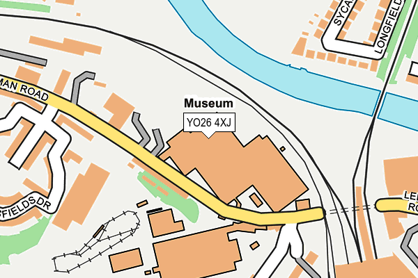
YO26 4XJ is located in the Holgate electoral ward, within the unitary authority of York and the English Parliamentary constituency of York Central. The Sub Integrated Care Board (ICB) Location is NHS Humber and North Yorkshire ICB - 03Q and the police force is North Yorkshire. This postcode has been in use since June 1998.


GetTheData
Source: OS OpenMap – Local (Ordnance Survey)
Source: OS VectorMap District (Ordnance Survey)
Licence: Open Government Licence (requires attribution)
| Easting | 459375 |
| Northing | 452009 |
| Latitude | 53.960767 |
| Longitude | -1.096551 |
GetTheData
Source: Open Postcode Geo
Licence: Open Government Licence
| Country | England |
| Postcode District | YO26 |
| ➜ YO26 open data dashboard ➜ See where YO26 is on a map ➜ Where is York? | |
GetTheData
Source: Land Registry Price Paid Data
Licence: Open Government Licence
Elevation or altitude of YO26 4XJ as distance above sea level:
| Metres | Feet | |
|---|---|---|
| Elevation | 10m | 33ft |
Elevation is measured from the approximate centre of the postcode, to the nearest point on an OS contour line from OS Terrain 50, which has contour spacing of ten vertical metres.
➜ How high above sea level am I? Find the elevation of your current position using your device's GPS.
GetTheData
Source: Open Postcode Elevation
Licence: Open Government Licence
| Ward | Holgate |
| Constituency | York Central |
GetTheData
Source: ONS Postcode Database
Licence: Open Government Licence
| October 2022 | Anti-social behaviour | On or near Bishopsfields Drive | 326m |
| August 2022 | Criminal damage and arson | On or near Bishopsfields Drive | 326m |
| June 2022 | Other theft | On or near Almery Terrace | 242m |
| ➜ Get more crime data in our Crime section | |||
GetTheData
Source: data.police.uk
Licence: Open Government Licence
| National Railway Museum (Leeman Road) | National Railway Museum | 68m |
| Nrm Car Park (Leeman Road) | National Railway Museum | 119m |
| National Railway Museum (Leeman Road) | National Railway Museum | 136m |
| Royal Mail Offices (Leeman Road) | York | 345m |
| Station Rise | York | 403m |
| York Station | 0.4km |
| Poppleton Station | 3.8km |
GetTheData
Source: NaPTAN
Licence: Open Government Licence
GetTheData
Source: ONS Postcode Database
Licence: Open Government Licence


➜ Get more ratings from the Food Standards Agency
GetTheData
Source: Food Standards Agency
Licence: FSA terms & conditions
| Last Collection | |||
|---|---|---|---|
| Location | Mon-Fri | Sat | Distance |
| Royal Mail York | 19:30 | 14:30 | 320m |
| Hetherton Street | 17:30 | 12:45 | 390m |
| Taxi Rank York Railway Station | 18:15 | 12:45 | 395m |
GetTheData
Source: Dracos
Licence: Creative Commons Attribution-ShareAlike
| Facility | Distance |
|---|---|
| Victoria Park (Leeman Road) Jubilee Terrace, York Grass Pitches | 376m |
| Principal York Hotel Health Club Station Road, York Health and Fitness Gym, Swimming Pool | 385m |
| York Ri Sports Centre Queen Street, York Health and Fitness Gym, Sports Hall, Squash Courts, Studio | 550m |
GetTheData
Source: Active Places
Licence: Open Government Licence
| School | Phase of Education | Distance |
|---|---|---|
| Saint Barnabas Church of England Voluntary Controlled Primary School Jubilee Terrace, Leeman Road, York, YO26 4YZ | Primary | 566m |
| St Peter's School 2-18 Clifton, York, YO30 6AB | Not applicable | 652m |
| St Paul's Church of England Voluntary Controlled Primary School St Paul's Terrace, Holgate, York, YO24 4BJ | Primary | 672m |
GetTheData
Source: Edubase
Licence: Open Government Licence
The below table lists the International Territorial Level (ITL) codes (formerly Nomenclature of Territorial Units for Statistics (NUTS) codes) and Local Administrative Units (LAU) codes for YO26 4XJ:
| ITL 1 Code | Name |
|---|---|
| TLE | Yorkshire and The Humber |
| ITL 2 Code | Name |
| TLE2 | North Yorkshire |
| ITL 3 Code | Name |
| TLE21 | York |
| LAU 1 Code | Name |
| E06000014 | York |
GetTheData
Source: ONS Postcode Directory
Licence: Open Government Licence
The below table lists the Census Output Area (OA), Lower Layer Super Output Area (LSOA), and Middle Layer Super Output Area (MSOA) for YO26 4XJ:
| Code | Name | |
|---|---|---|
| OA | E00170143 | |
| LSOA | E01013391 | York 017B |
| MSOA | E02002788 | York 017 |
GetTheData
Source: ONS Postcode Directory
Licence: Open Government Licence
| YO26 4ZL | Bishopfields Cloisters | 200m |
| YO26 4WT | Leeman Road | 208m |
| YO30 7DL | Almery Terrace | 219m |
| YO26 4WN | Bishopfields Drive | 253m |
| YO26 4WX | Phoenix Boulevard | 256m |
| YO26 4GA | Holgate Road | 279m |
| YO26 4WU | Phoenix Boulevard | 280m |
| YO26 4US | Aldborough Way | 290m |
| YO30 7DN | Sycamore Terrace | 309m |
| YO30 7BQ | Earlsborough Terrace | 321m |
GetTheData
Source: Open Postcode Geo; Land Registry Price Paid Data
Licence: Open Government Licence