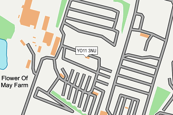
YO11 3NU is located in the Cayton electoral ward, within the unitary authority of North Yorkshire and the English Parliamentary constituency of Scarborough and Whitby. The Sub Integrated Care Board (ICB) Location is NHS Humber and North Yorkshire ICB - 42D and the police force is North Yorkshire. This postcode has been in use since January 1995.


GetTheData
Source: OS OpenMap – Local (Ordnance Survey)
Source: OS VectorMap District (Ordnance Survey)
Licence: Open Government Licence (requires attribution)
| Easting | 508356 |
| Northing | 483350 |
| Latitude | 54.234417 |
| Longitude | -0.339099 |
GetTheData
Source: Open Postcode Geo
Licence: Open Government Licence
| Country | England |
| Postcode District | YO11 |
| ➜ YO11 open data dashboard ➜ See where YO11 is on a map | |
GetTheData
Source: Land Registry Price Paid Data
Licence: Open Government Licence
Elevation or altitude of YO11 3NU as distance above sea level:
| Metres | Feet | |
|---|---|---|
| Elevation | 70m | 230ft |
Elevation is measured from the approximate centre of the postcode, to the nearest point on an OS contour line from OS Terrain 50, which has contour spacing of ten vertical metres.
➜ How high above sea level am I? Find the elevation of your current position using your device's GPS.
GetTheData
Source: Open Postcode Elevation
Licence: Open Government Licence
| Ward | Cayton |
| Constituency | Scarborough And Whitby |
GetTheData
Source: ONS Postcode Database
Licence: Open Government Licence
| Flower Of May (Stonepit Lane) | Lebberston | 625m |
| Flower Of May (Stonepit Lane) | Lebberston | 635m |
| Crow's Nest (Stonepit Lane) | Lebberston | 718m |
| Crow's Nest (Stonepit Lane) | Lebberston | 731m |
| Blue Dolphin (Sea Approach) | Gristhorpe | 931m |
| Filey Station | 4km |
| Scarborough Station | 6.7km |
GetTheData
Source: NaPTAN
Licence: Open Government Licence
GetTheData
Source: ONS Postcode Database
Licence: Open Government Licence


➜ Get more ratings from the Food Standards Agency
GetTheData
Source: Food Standards Agency
Licence: FSA terms & conditions
| Last Collection | |||
|---|---|---|---|
| Location | Mon-Fri | Sat | Distance |
| Gristhorpe Village | 16:40 | 12:20 | 1,471m |
| Osgodby Post Office | 17:00 | 12:10 | 2,956m |
| Priory Stores Osgodby Lane | 18:00 | 12:15 | 3,088m |
GetTheData
Source: Dracos
Licence: Creative Commons Attribution-ShareAlike
| Facility | Distance |
|---|---|
| Lebberston Golf Club (Closed) Off Stonepit Lane, Lebberston, Scarborough Golf | 228m |
| Blue Dolphin Holiday Park Gristhorpe, Filey Swimming Pool | 1.2km |
| Cayton School Mill Lane, Cayton Bay, Scarborough Grass Pitches | 2.5km |
GetTheData
Source: Active Places
Licence: Open Government Licence
| School | Phase of Education | Distance |
|---|---|---|
| Cayton Community Primary School Mill Lane, Cayton, Scarborough, YO11 3NN | Primary | 2.5km |
| George Pindar School Moor Lane, Eastfield, Scarborough, YO11 3LW | Secondary | 3.6km |
| St George's Catholic Primary School - a Catholic voluntary academy Overdale, Eastfield, Scarborough, YO11 3RE | Primary | 3.6km |
GetTheData
Source: Edubase
Licence: Open Government Licence
The below table lists the International Territorial Level (ITL) codes (formerly Nomenclature of Territorial Units for Statistics (NUTS) codes) and Local Administrative Units (LAU) codes for YO11 3NU:
| ITL 1 Code | Name |
|---|---|
| TLE | Yorkshire and The Humber |
| ITL 2 Code | Name |
| TLE2 | North Yorkshire |
| ITL 3 Code | Name |
| TLE22 | North Yorkshire CC |
| LAU 1 Code | Name |
| E07000168 | Scarborough |
GetTheData
Source: ONS Postcode Directory
Licence: Open Government Licence
The below table lists the Census Output Area (OA), Lower Layer Super Output Area (LSOA), and Middle Layer Super Output Area (MSOA) for YO11 3NU:
| Code | Name | |
|---|---|---|
| OA | E00141660 | |
| LSOA | E01027807 | Scarborough 011A |
| MSOA | E02005805 | Scarborough 011 |
GetTheData
Source: ONS Postcode Directory
Licence: Open Government Licence
| YO14 9PT | 739m | |
| YO11 3PA | 931m | |
| YO11 3PD | Grange Close | 959m |
| YO11 3PB | Manor View Road | 1019m |
| YO11 3PE | 1039m | |
| YO11 3PF | Green Lane | 1188m |
| YO14 9PU | Dolphin Way | 1281m |
| YO14 9PH | Filey Road | 1328m |
| YO14 9PL | Back Lane | 1392m |
| YO14 9PY | Dovecot Close | 1405m |
GetTheData
Source: Open Postcode Geo; Land Registry Price Paid Data
Licence: Open Government Licence