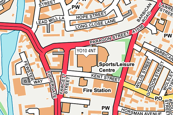
YO10 4NT is located in the Fishergate electoral ward, within the unitary authority of York and the English Parliamentary constituency of York Central. The Sub Integrated Care Board (ICB) Location is NHS Humber and North Yorkshire ICB - 03Q and the police force is North Yorkshire. This postcode has been in use since June 2011.


GetTheData
Source: OS OpenMap – Local (Ordnance Survey)
Source: OS VectorMap District (Ordnance Survey)
Licence: Open Government Licence (requires attribution)
| Easting | 460848 |
| Northing | 451211 |
| Latitude | 53.953425 |
| Longitude | -1.074263 |
GetTheData
Source: Open Postcode Geo
Licence: Open Government Licence
| Country | England |
| Postcode District | YO10 |
| ➜ YO10 open data dashboard ➜ See where YO10 is on a map ➜ Where is York? | |
GetTheData
Source: Land Registry Price Paid Data
Licence: Open Government Licence
Elevation or altitude of YO10 4NT as distance above sea level:
| Metres | Feet | |
|---|---|---|
| Elevation | 10m | 33ft |
Elevation is measured from the approximate centre of the postcode, to the nearest point on an OS contour line from OS Terrain 50, which has contour spacing of ten vertical metres.
➜ How high above sea level am I? Find the elevation of your current position using your device's GPS.
GetTheData
Source: Open Postcode Elevation
Licence: Open Government Licence
| Ward | Fishergate |
| Constituency | York Central |
GetTheData
Source: ONS Postcode Database
Licence: Open Government Licence
| January 2024 | Anti-social behaviour | On or near St Denys' Road | 362m |
| January 2024 | Shoplifting | On or near Leake Street | 398m |
| December 2023 | Public order | On or near Alne Terrace | 366m |
| ➜ Get more crime data in our Crime section | |||
GetTheData
Source: data.police.uk
Licence: Open Government Licence
| The Barbican Coach Stop (Fawcett Street) | York | 61m |
| The Barbican (Fawcett Street) | York | 64m |
| The Barbican (Kent Street) | York | 89m |
| Barbican Road | York | 135m |
| Barbican Road | York | 147m |
| York Station | 1.3km |
| Poppleton Station | 5.5km |
GetTheData
Source: NaPTAN
Licence: Open Government Licence
GetTheData
Source: ONS Postcode Database
Licence: Open Government Licence


➜ Get more ratings from the Food Standards Agency
GetTheData
Source: Food Standards Agency
Licence: FSA terms & conditions
| Last Collection | |||
|---|---|---|---|
| Location | Mon-Fri | Sat | Distance |
| Castle Mills Bridge | 18:30 | 12:15 | 153m |
| Walmgate Bar Post Office | 18:30 | 12:00 | 286m |
| Marlborough Grove | 17:45 | 12:15 | 295m |
GetTheData
Source: Dracos
Licence: Creative Commons Attribution-ShareAlike
| Facility | Distance |
|---|---|
| York Barbican Centre (Closed) Paragon Street, York Sports Hall, Studio, Swimming Pool, Health and Fitness Gym | 1m |
| Fishergate Primary School Fishergate, York Sports Hall, Grass Pitches | 188m |
| Tramways Working Mens Club (Closed) Mill Street, York Sports Hall | 217m |
GetTheData
Source: Active Places
Licence: Open Government Licence
| School | Phase of Education | Distance |
|---|---|---|
| Fishergate Primary School Fishergate, York, YO10 4AP | Primary | 199m |
| St George's Catholic Primary School - a Catholic Voluntary Academy 1 Winterscale Street, Fishergate, York, YO10 4BT | Primary | 290m |
| St Lawrence's Church of England Primary School Heslington Road, York, YO10 5BW | Primary | 597m |
GetTheData
Source: Edubase
Licence: Open Government Licence
The below table lists the International Territorial Level (ITL) codes (formerly Nomenclature of Territorial Units for Statistics (NUTS) codes) and Local Administrative Units (LAU) codes for YO10 4NT:
| ITL 1 Code | Name |
|---|---|
| TLE | Yorkshire and The Humber |
| ITL 2 Code | Name |
| TLE2 | North Yorkshire |
| ITL 3 Code | Name |
| TLE21 | York |
| LAU 1 Code | Name |
| E06000014 | York |
GetTheData
Source: ONS Postcode Directory
Licence: Open Government Licence
The below table lists the Census Output Area (OA), Lower Layer Super Output Area (LSOA), and Middle Layer Super Output Area (MSOA) for YO10 4NT:
| Code | Name | |
|---|---|---|
| OA | E00067451 | |
| LSOA | E01013363 | York 019D |
| MSOA | E02002790 | York 019 |
GetTheData
Source: ONS Postcode Directory
Licence: Open Government Licence
| YO10 4BZ | Fawcett Street | 55m |
| YO10 4BF | Fawcett Street | 55m |
| YO10 4AH | Fawcett Street | 97m |
| YO10 4AQ | Fawcett Street | 104m |
| YO10 4UP | Long Close Lane | 109m |
| YO10 4FN | Kent Street | 113m |
| YO10 4AE | Fishergate | 121m |
| YO1 9PT | George Street | 124m |
| YO1 9QQ | Turpin Court | 127m |
| YO10 4EP | Little Kent Mews | 129m |
GetTheData
Source: Open Postcode Geo; Land Registry Price Paid Data
Licence: Open Government Licence