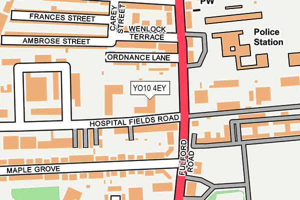
YO10 4EY is located in the Fishergate electoral ward, within the unitary authority of York and the English Parliamentary constituency of York Central. The Sub Integrated Care Board (ICB) Location is NHS Humber and North Yorkshire ICB - 03Q and the police force is North Yorkshire. This postcode has been in use since January 2005.


GetTheData
Source: OS OpenMap – Local (Ordnance Survey)
Source: OS VectorMap District (Ordnance Survey)
Licence: Open Government Licence (requires attribution)
| Easting | 460822 |
| Northing | 450326 |
| Latitude | 53.945475 |
| Longitude | -1.074835 |
GetTheData
Source: Open Postcode Geo
Licence: Open Government Licence
| Country | England |
| Postcode District | YO10 |
| ➜ YO10 open data dashboard ➜ See where YO10 is on a map ➜ Where is York? | |
GetTheData
Source: Land Registry Price Paid Data
Licence: Open Government Licence
Elevation or altitude of YO10 4EY as distance above sea level:
| Metres | Feet | |
|---|---|---|
| Elevation | 10m | 33ft |
Elevation is measured from the approximate centre of the postcode, to the nearest point on an OS contour line from OS Terrain 50, which has contour spacing of ten vertical metres.
➜ How high above sea level am I? Find the elevation of your current position using your device's GPS.
GetTheData
Source: Open Postcode Elevation
Licence: Open Government Licence
| Ward | Fishergate |
| Constituency | York Central |
GetTheData
Source: ONS Postcode Database
Licence: Open Government Licence
| January 2024 | Violence and sexual offences | On or near Supermarket | 202m |
| January 2024 | Violence and sexual offences | On or near Supermarket | 202m |
| December 2023 | Possession of weapons | On or near Supermarket | 202m |
| ➜ Get more crime data in our Crime section | |||
GetTheData
Source: data.police.uk
Licence: Open Government Licence
| Bus Depot (Hospital Fields Road) | Fulford Road | 90m |
| Bus Depot (Hospital Fields Road) | Fulford Road | 96m |
| Alma Terrace (Fulford Road) | Fulford Road | 172m |
| Alma Terrace (Fulford Road) | Fulford Road | 219m |
| Imphal Barracks (Fulford Road) | Fulford Road | 220m |
| York Station | 1.8km |
| Poppleton Station | 5.9km |
GetTheData
Source: NaPTAN
Licence: Open Government Licence
GetTheData
Source: ONS Postcode Database
Licence: Open Government Licence


➜ Get more ratings from the Food Standards Agency
GetTheData
Source: Food Standards Agency
Licence: FSA terms & conditions
| Last Collection | |||
|---|---|---|---|
| Location | Mon-Fri | Sat | Distance |
| Hospital Fields Road | 17:30 | 12:15 | 160m |
| (Franked) Aldi Fulford Road | 17:45 | 12:15 | 163m |
| Fulford Road | 17:45 | 12:15 | 191m |
GetTheData
Source: Dracos
Licence: Creative Commons Attribution-ShareAlike
| Facility | Distance |
|---|---|
| Imphal Barracks Fulford Road, York Health and Fitness Gym, Sports Hall, Artificial Grass Pitch, Squash Courts, Grass Pitches, Outdoor Tennis Courts | 225m |
| Ebor Fitness Hospital Fields Road, Fulford Industrial Estate, York Health and Fitness Gym | 273m |
| Rowntree Park Terry Avenue, York Outdoor Tennis Courts, Grass Pitches | 502m |
GetTheData
Source: Active Places
Licence: Open Government Licence
| School | Phase of Education | Distance |
|---|---|---|
| Danesgate Community Danesgate, Fulford Cross, York, YO10 4PB | Not applicable | 251m |
| York Steiner School Danesmead, Fulford Cross, York, YO10 4PB | Not applicable | 359m |
| St George's Catholic Primary School - a Catholic Voluntary Academy 1 Winterscale Street, Fishergate, York, YO10 4BT | Primary | 595m |
GetTheData
Source: Edubase
Licence: Open Government Licence
The below table lists the International Territorial Level (ITL) codes (formerly Nomenclature of Territorial Units for Statistics (NUTS) codes) and Local Administrative Units (LAU) codes for YO10 4EY:
| ITL 1 Code | Name |
|---|---|
| TLE | Yorkshire and The Humber |
| ITL 2 Code | Name |
| TLE2 | North Yorkshire |
| ITL 3 Code | Name |
| TLE21 | York |
| LAU 1 Code | Name |
| E06000014 | York |
GetTheData
Source: ONS Postcode Directory
Licence: Open Government Licence
The below table lists the Census Output Area (OA), Lower Layer Super Output Area (LSOA), and Middle Layer Super Output Area (MSOA) for YO10 4EY:
| Code | Name | |
|---|---|---|
| OA | E00067441 | |
| LSOA | E01013361 | York 019B |
| MSOA | E02002790 | York 019 |
GetTheData
Source: ONS Postcode Directory
Licence: Open Government Licence
| YO10 4FE | Hospital Fields Road | 67m |
| YO10 4FF | Hospital Fields Road | 71m |
| YO10 4EQ | Fulford Road | 107m |
| YO10 4DX | Fulford Road | 110m |
| YO10 4DU | Wenlock Terrace | 115m |
| YO10 4EE | Hospital Fields | 120m |
| YO10 4ED | The Stables | 126m |
| YO10 4EF | Hospital Fields | 142m |
| YO10 4ER | Millennium Bridge Terrace | 180m |
| YO10 4DD | Fulford Road | 184m |
GetTheData
Source: Open Postcode Geo; Land Registry Price Paid Data
Licence: Open Government Licence