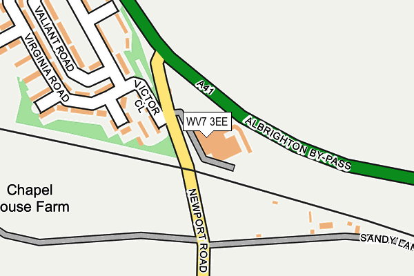
WV7 3EE is located in the Shifnal South and Cosford electoral ward, within the unitary authority of Shropshire and the English Parliamentary constituency of The Wrekin. The Sub Integrated Care Board (ICB) Location is NHS Shropshire, Telford and Wrekin ICB - M2L0M and the police force is West Mercia. This postcode has been in use since August 1992.


GetTheData
Source: OS OpenMap – Local (Ordnance Survey)
Source: OS VectorMap District (Ordnance Survey)
Licence: Open Government Licence (requires attribution)
| Easting | 380538 |
| Northing | 305207 |
| Latitude | 52.644249 |
| Longitude | -2.289068 |
GetTheData
Source: Open Postcode Geo
Licence: Open Government Licence
| Country | England |
| Postcode District | WV7 |
| ➜ WV7 open data dashboard ➜ See where WV7 is on a map | |
GetTheData
Source: Land Registry Price Paid Data
Licence: Open Government Licence
Elevation or altitude of WV7 3EE as distance above sea level:
| Metres | Feet | |
|---|---|---|
| Elevation | 90m | 295ft |
Elevation is measured from the approximate centre of the postcode, to the nearest point on an OS contour line from OS Terrain 50, which has contour spacing of ten vertical metres.
➜ How high above sea level am I? Find the elevation of your current position using your device's GPS.
GetTheData
Source: Open Postcode Elevation
Licence: Open Government Licence
| Ward | Shifnal South And Cosford |
| Constituency | The Wrekin |
GetTheData
Source: ONS Postcode Database
Licence: Open Government Licence
| June 2022 | Burglary | On or near Virginia Road | 275m |
| April 2022 | Vehicle crime | On or near Victor Close | 98m |
| April 2022 | Public order | On or near Sports/Recreation Area | 495m |
| ➜ Get more crime data in our Crime section | |||
GetTheData
Source: data.police.uk
Licence: Open Government Licence
| Garage (Newport Road) | Cosford | 464m |
| Garage (Newport Road) | Cosford | 497m |
| Fire Station (Newport Road) | Albrighton | 511m |
| Fire Station (Newport Road) | Albrighton | 518m |
| St Cuthberts Crescent (Bowling Green Lane) | Albrighton | 822m |
| Cosford Station | 0.8km |
| Albrighton Station | 1.5km |
GetTheData
Source: NaPTAN
Licence: Open Government Licence
GetTheData
Source: ONS Postcode Database
Licence: Open Government Licence


➜ Get more ratings from the Food Standards Agency
GetTheData
Source: Food Standards Agency
Licence: FSA terms & conditions
| Last Collection | |||
|---|---|---|---|
| Location | Mon-Fri | Sat | Distance |
| Albrighton Post Office | 17:30 | 12:00 | 1,245m |
| Tong | 10:15 | 10:15 | 2,336m |
| Tong Norton | 11:30 | 09:15 | 3,095m |
GetTheData
Source: Dracos
Licence: Creative Commons Attribution-ShareAlike
| Facility | Distance |
|---|---|
| Clockmills Worthington Drive, Albrighton Grass Pitches | 512m |
| Elysium Health Club (Albrighton) (Closed) Rectory Road, Albrighton, Wolverhampton Health and Fitness Gym, Swimming Pool, Studio | 692m |
| Loak Road Loak Road, Albrighton, Wolverhampton Grass Pitches | 843m |
GetTheData
Source: Active Places
Licence: Open Government Licence
| School | Phase of Education | Distance |
|---|---|---|
| Albrighton Primary School & Nursery New House Lane, Albrighton, Wolverhampton, WV7 3QS | Primary | 1.4km |
| St Mary's CofE Primary School Shaw Lane, Albrighton, Wolverhampton, WV7 3DS | Primary | 1.5km |
| The Gables Learning Centre The Gables Learning Centre, Beamish Lane, Albrighton, Shropshire, WV7 3AG | Not applicable | 2.4km |
GetTheData
Source: Edubase
Licence: Open Government Licence
The below table lists the International Territorial Level (ITL) codes (formerly Nomenclature of Territorial Units for Statistics (NUTS) codes) and Local Administrative Units (LAU) codes for WV7 3EE:
| ITL 1 Code | Name |
|---|---|
| TLG | West Midlands (England) |
| ITL 2 Code | Name |
| TLG2 | Shropshire and Staffordshire |
| ITL 3 Code | Name |
| TLG22 | Shropshire |
| LAU 1 Code | Name |
| E06000051 | Shropshire |
GetTheData
Source: ONS Postcode Directory
Licence: Open Government Licence
The below table lists the Census Output Area (OA), Lower Layer Super Output Area (LSOA), and Middle Layer Super Output Area (MSOA) for WV7 3EE:
| Code | Name | |
|---|---|---|
| OA | E00146910 | |
| LSOA | E01028845 | Shropshire 027D |
| MSOA | E02006009 | Shropshire 027 |
GetTheData
Source: ONS Postcode Directory
Licence: Open Government Licence
| WV7 3ES | Sandy Lane | 214m |
| WV7 3ET | Newport Road | 350m |
| WV7 3NB | Sydnal Lane | 507m |
| WV7 3EP | Rectory Road | 532m |
| WV7 3EW | Newport Road | 583m |
| WV7 3EN | Grange Park | 665m |
| WV7 3HW | St Cuthberts Crescent | 704m |
| WV7 3HS | Loak Road | 707m |
| WV7 3EH | Newport Road | 732m |
| WV7 3HN | Bowling Green Lane | 788m |
GetTheData
Source: Open Postcode Geo; Land Registry Price Paid Data
Licence: Open Government Licence