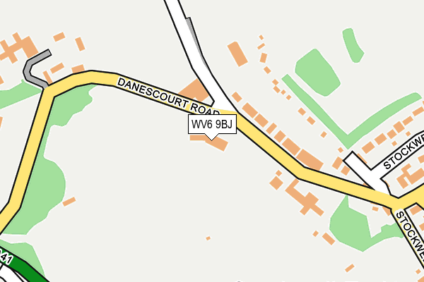
WV6 9BJ is located in the Tettenhall Regis electoral ward, within the metropolitan district of Wolverhampton and the English Parliamentary constituency of Wolverhampton South West. The Sub Integrated Care Board (ICB) Location is NHS Black Country ICB - D2P2L and the police force is West Midlands. This postcode has been in use since January 1980.


GetTheData
Source: OS OpenMap – Local (Ordnance Survey)
Source: OS VectorMap District (Ordnance Survey)
Licence: Open Government Licence (requires attribution)
| Easting | 388539 |
| Northing | 300621 |
| Latitude | 52.603267 |
| Longitude | -2.170655 |
GetTheData
Source: Open Postcode Geo
Licence: Open Government Licence
| Country | England |
| Postcode District | WV6 |
| ➜ WV6 open data dashboard ➜ See where WV6 is on a map ➜ Where is Wolverhampton? | |
GetTheData
Source: Land Registry Price Paid Data
Licence: Open Government Licence
Elevation or altitude of WV6 9BJ as distance above sea level:
| Metres | Feet | |
|---|---|---|
| Elevation | 140m | 459ft |
Elevation is measured from the approximate centre of the postcode, to the nearest point on an OS contour line from OS Terrain 50, which has contour spacing of ten vertical metres.
➜ How high above sea level am I? Find the elevation of your current position using your device's GPS.
GetTheData
Source: Open Postcode Elevation
Licence: Open Government Licence
| Ward | Tettenhall Regis |
| Constituency | Wolverhampton South West |
GetTheData
Source: ONS Postcode Database
Licence: Open Government Licence
| December 2023 | Anti-social behaviour | On or near Chilgrove Gardens | 457m |
| December 2023 | Other theft | On or near Chilgrove Gardens | 457m |
| December 2023 | Burglary | On or near Clifton Road | 499m |
| ➜ Get more crime data in our Crime section | |||
GetTheData
Source: data.police.uk
Licence: Open Government Licence
| Wrottesley Rd (Wergs Rd) | Tettenhall | 348m |
| Danescourt Rd (Wergs Rd) | Tettenhall | 373m |
| Wrottesley Rd (Wergs Rd) | Tettenhall | 373m |
| Danescourt Rd (Wergs Rd) | Tettenhall | 433m |
| Regis Rd (Wergs Rd) | Tettenhall | 443m |
| Bilbrook Station | 2.5km |
| Codsall Station | 3.4km |
| Wolverhampton Station | 3.9km |
GetTheData
Source: NaPTAN
Licence: Open Government Licence
GetTheData
Source: ONS Postcode Database
Licence: Open Government Licence


➜ Get more ratings from the Food Standards Agency
GetTheData
Source: Food Standards Agency
Licence: FSA terms & conditions
| Last Collection | |||
|---|---|---|---|
| Location | Mon-Fri | Sat | Distance |
| Stockwell End | 16:45 | 12:00 | 400m |
| Lowlands Avenue | 17:15 | 12:00 | 770m |
| Pendeford Post Office | 18:15 | 12:00 | 1,036m |
GetTheData
Source: Dracos
Licence: Creative Commons Attribution-ShareAlike
| Facility | Distance |
|---|---|
| Wolverhampton Cricket Club Danescourt Road, Wolverhampton Grass Pitches, Outdoor Tennis Courts | 0m |
| The South Staffordshire Golf Club Ltd Danescourt Road, Wolverhampton Golf | 80m |
| Chris Jewkes Fitness Health Club Danescourt Road, Wolverhampton Grass Pitches | 309m |
GetTheData
Source: Active Places
Licence: Open Government Licence
| School | Phase of Education | Distance |
|---|---|---|
| Tettenhall College Incorporated Wood Road, Tettenhall, Wolverhampton, WV6 8QX | Not applicable | 831m |
| St Michael's Church of England Aided Primary School Lower Street, Tettenhall, Wolverhampton, WV6 9AF | Primary | 838m |
| Tettenhall Wood School Regis Road, Tettenhall, Wolverhampton, WV6 8XF | Not applicable | 975m |
GetTheData
Source: Edubase
Licence: Open Government Licence
The below table lists the International Territorial Level (ITL) codes (formerly Nomenclature of Territorial Units for Statistics (NUTS) codes) and Local Administrative Units (LAU) codes for WV6 9BJ:
| ITL 1 Code | Name |
|---|---|
| TLG | West Midlands (England) |
| ITL 2 Code | Name |
| TLG3 | West Midlands |
| ITL 3 Code | Name |
| TLG39 | Wolverhampton |
| LAU 1 Code | Name |
| E08000031 | Wolverhampton |
GetTheData
Source: ONS Postcode Directory
Licence: Open Government Licence
The below table lists the Census Output Area (OA), Lower Layer Super Output Area (LSOA), and Middle Layer Super Output Area (MSOA) for WV6 9BJ:
| Code | Name | |
|---|---|---|
| OA | E00053228 | |
| LSOA | E01010540 | Wolverhampton 009B |
| MSOA | E02002157 | Wolverhampton 009 |
GetTheData
Source: ONS Postcode Directory
Licence: Open Government Licence
| WV6 9BG | Danescourt Road | 84m |
| WV6 9BE | Danescourt Road | 175m |
| WV6 9PH | Stockwell End | 255m |
| WV6 9BH | Danescourt Road | 291m |
| WV6 9PQ | Stockwell Road | 355m |
| WV6 8TB | College Place | 361m |
| WV6 9PG | Stockwell Road | 366m |
| WV6 9PJ | Love Lane | 381m |
| WV6 8SE | The Drive | 393m |
| WV6 8SD | Wrottesley Road | 399m |
GetTheData
Source: Open Postcode Geo; Land Registry Price Paid Data
Licence: Open Government Licence