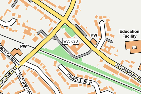
WV6 6SU is located in the Codsall electoral ward, within the local authority district of South Staffordshire and the English Parliamentary constituency of South Staffordshire. The Sub Integrated Care Board (ICB) Location is NHS Staffordshire and Stoke-on-Trent ICB - 05Q and the police force is Staffordshire. This postcode has been in use since February 2005.


GetTheData
Source: OS OpenMap – Local (Ordnance Survey)
Source: OS VectorMap District (Ordnance Survey)
Licence: Open Government Licence (requires attribution)
| Easting | 387103 |
| Northing | 303118 |
| Latitude | 52.625667 |
| Longitude | -2.191961 |
GetTheData
Source: Open Postcode Geo
Licence: Open Government Licence
| Country | England |
| Postcode District | WV6 |
| ➜ WV6 open data dashboard ➜ See where WV6 is on a map ➜ Where is Codsall? | |
GetTheData
Source: Land Registry Price Paid Data
Licence: Open Government Licence
Elevation or altitude of WV6 6SU as distance above sea level:
| Metres | Feet | |
|---|---|---|
| Elevation | 120m | 394ft |
Elevation is measured from the approximate centre of the postcode, to the nearest point on an OS contour line from OS Terrain 50, which has contour spacing of ten vertical metres.
➜ How high above sea level am I? Find the elevation of your current position using your device's GPS.
GetTheData
Source: Open Postcode Elevation
Licence: Open Government Licence
| Ward | Codsall |
| Constituency | South Staffordshire |
GetTheData
Source: ONS Postcode Database
Licence: Open Government Licence
| January 2024 | Violence and sexual offences | On or near Forsythia Grove | 386m |
| January 2024 | Violence and sexual offences | On or near Forsythia Grove | 386m |
| October 2023 | Other theft | On or near Forsythia Grove | 386m |
| ➜ Get more crime data in our Crime section | |||
GetTheData
Source: data.police.uk
Licence: Open Government Licence
| Council Offices (Wolverhampton Road) | Codsall | 60m |
| Council Offices (Wolverhampton Road) | Codsall | 75m |
| Clinic (Elliotts Lane) | Codsall | 153m |
| Clinic (Elliotts Lane) | Codsall | 162m |
| Histons Hill (Wolverhampton Road) | Codsall | 216m |
| Bilbrook Station | 0.5km |
| Codsall Station | 0.7km |
| Wolverhampton Station | 6.5km |
GetTheData
Source: NaPTAN
Licence: Open Government Licence
GetTheData
Source: ONS Postcode Database
Licence: Open Government Licence


➜ Get more ratings from the Food Standards Agency
GetTheData
Source: Food Standards Agency
Licence: FSA terms & conditions
| Last Collection | |||
|---|---|---|---|
| Location | Mon-Fri | Sat | Distance |
| Elliots Lane | 16:45 | 12:30 | 255m |
| Oaken Lane | 17:00 | 12:00 | 851m |
| Oaken | 16:00 | 11:30 | 1,327m |
GetTheData
Source: Dracos
Licence: Creative Commons Attribution-ShareAlike
| Facility | Distance |
|---|---|
| Codsall Leisure Centre Elliotts Lane, Codsall, Wolverhampton Sports Hall, Swimming Pool, Health and Fitness Gym, Studio, Squash Courts, Artificial Grass Pitch | 271m |
| Codsall Middle School Wolverhampton Road, Codsall, Wolverhampton Grass Pitches | 272m |
| Codsall Village Hall Wolverhampton Road, Codsall, Wolverhampton Grass Pitches, Sports Hall | 471m |
GetTheData
Source: Active Places
Licence: Open Government Licence
| School | Phase of Education | Distance |
|---|---|---|
| Codsall Middle School Wolverhampton Road, Codsall, Wolverhampton, WV8 1PB | Middle deemed secondary | 0m |
| Codsall Community High School Elliotts Lane, Codsall, Wolverhampton, WV8 1PQ | Secondary | 268m |
| St Christopher's Catholic Primary Academy Wolverhampton Road, Codsall, Wolverhampton, WV8 1PF | Primary | 315m |
GetTheData
Source: Edubase
Licence: Open Government Licence
The below table lists the International Territorial Level (ITL) codes (formerly Nomenclature of Territorial Units for Statistics (NUTS) codes) and Local Administrative Units (LAU) codes for WV6 6SU:
| ITL 1 Code | Name |
|---|---|
| TLG | West Midlands (England) |
| ITL 2 Code | Name |
| TLG2 | Shropshire and Staffordshire |
| ITL 3 Code | Name |
| TLG24 | Staffordshire CC |
| LAU 1 Code | Name |
| E07000196 | South Staffordshire |
GetTheData
Source: ONS Postcode Directory
Licence: Open Government Licence
The below table lists the Census Output Area (OA), Lower Layer Super Output Area (LSOA), and Middle Layer Super Output Area (MSOA) for WV6 6SU:
| Code | Name | |
|---|---|---|
| OA | E00150956 | |
| LSOA | E01029627 | South Staffordshire 008D |
| MSOA | E02006181 | South Staffordshire 008 |
GetTheData
Source: ONS Postcode Directory
Licence: Open Government Licence
| WV8 2DJ | Princes Drive | 123m |
| WV8 1AA | Histons Hill | 134m |
| WV8 1PF | Wolverhampton Road | 169m |
| WV8 1PA | Primrose Gardens | 183m |
| WV8 2DH | Princes Gardens | 194m |
| WV8 1PJ | Wolverhampton Road | 211m |
| WV8 2ES | Histons Hill | 231m |
| WV8 1BW | Ravenhill Drive | 251m |
| WV8 2DL | Princes Gardens | 258m |
| WV8 1PL | Wolverhampton Road | 283m |
GetTheData
Source: Open Postcode Geo; Land Registry Price Paid Data
Licence: Open Government Licence