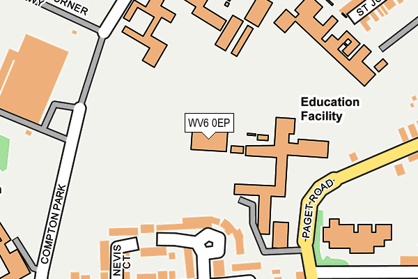
WV6 0EP is located in the Park electoral ward, within the metropolitan district of Wolverhampton and the English Parliamentary constituency of Wolverhampton South West. The Sub Integrated Care Board (ICB) Location is NHS Black Country ICB - D2P2L and the police force is West Midlands. This postcode has been in use since January 2010.


GetTheData
Source: OS OpenMap – Local (Ordnance Survey)
Source: OS VectorMap District (Ordnance Survey)
Licence: Open Government Licence (requires attribution)
| Easting | 389372 |
| Northing | 299100 |
| Latitude | 52.589595 |
| Longitude | -2.158311 |
GetTheData
Source: Open Postcode Geo
Licence: Open Government Licence
| Country | England |
| Postcode District | WV6 |
| ➜ WV6 open data dashboard ➜ See where WV6 is on a map ➜ Where is Wolverhampton? | |
GetTheData
Source: Land Registry Price Paid Data
Licence: Open Government Licence
Elevation or altitude of WV6 0EP as distance above sea level:
| Metres | Feet | |
|---|---|---|
| Elevation | 120m | 394ft |
Elevation is measured from the approximate centre of the postcode, to the nearest point on an OS contour line from OS Terrain 50, which has contour spacing of ten vertical metres.
➜ How high above sea level am I? Find the elevation of your current position using your device's GPS.
GetTheData
Source: Open Postcode Elevation
Licence: Open Government Licence
| Ward | Park |
| Constituency | Wolverhampton South West |
GetTheData
Source: ONS Postcode Database
Licence: Open Government Licence
| March 2023 | Violence and sexual offences | On or near Newbridge Crescent | 447m |
| December 2022 | Public order | On or near Newbridge Crescent | 447m |
| June 2022 | Criminal damage and arson | On or near Pentland Drive | 171m |
| ➜ Get more crime data in our Crime section | |||
GetTheData
Source: data.police.uk
Licence: Open Government Licence
| Compton Park | Newbridge | 253m |
| Compton Park | Newbridge | 258m |
| Hatton Rd (Paget Rd) | Newbridge | 270m |
| Compton Park Schools (Compton Park) | Newbridge | 273m |
| Hatton Rd (Paget Rd) | Newbridge | 279m |
| Wolverhampton Station | 2.6km |
| Bilbrook Station | 4.2km |
| Codsall Station | 5.1km |
GetTheData
Source: NaPTAN
Licence: Open Government Licence
GetTheData
Source: ONS Postcode Database
Licence: Open Government Licence


➜ Get more ratings from the Food Standards Agency
GetTheData
Source: Food Standards Agency
Licence: FSA terms & conditions
| Last Collection | |||
|---|---|---|---|
| Location | Mon-Fri | Sat | Distance |
| Avenue Road | 16:00 | 12:45 | 365m |
| Clark Road | 16:15 | 12:00 | 415m |
| Albert Road | 17:00 | 12:30 | 549m |
GetTheData
Source: Dracos
Licence: Creative Commons Attribution-ShareAlike
| Facility | Distance |
|---|---|
| Compton Park Recreation Centre (Closed) Paget Road, Wolverhampton Sports Hall, Swimming Pool | 154m |
| Wolverhampton Girls' High School Tettenhall Road, Wolverhampton Grass Pitches, Sports Hall | 229m |
| St. Peter's Collegiate School Compton Road West, Wolverhampton Sports Hall, Health and Fitness Gym, Grass Pitches, Outdoor Tennis Courts | 230m |
GetTheData
Source: Active Places
Licence: Open Government Licence
| School | Phase of Education | Distance |
|---|---|---|
| City of Wolverhampton College Paget Road, Wolverhampton, WV6 0DU | 16 plus | 110m |
| Wolverhampton Girls' High School Tettenhall Road, Tettenhall, Wolverhampton, WV6 0BY | Secondary | 220m |
| St Edmund's Catholic Academy Compton Park, Compton Road West, Wolverhampton, WV3 9DU | Secondary | 276m |
GetTheData
Source: Edubase
Licence: Open Government Licence
The below table lists the International Territorial Level (ITL) codes (formerly Nomenclature of Territorial Units for Statistics (NUTS) codes) and Local Administrative Units (LAU) codes for WV6 0EP:
| ITL 1 Code | Name |
|---|---|
| TLG | West Midlands (England) |
| ITL 2 Code | Name |
| TLG3 | West Midlands |
| ITL 3 Code | Name |
| TLG39 | Wolverhampton |
| LAU 1 Code | Name |
| E08000031 | Wolverhampton |
GetTheData
Source: ONS Postcode Directory
Licence: Open Government Licence
The below table lists the Census Output Area (OA), Lower Layer Super Output Area (LSOA), and Middle Layer Super Output Area (MSOA) for WV6 0EP:
| Code | Name | |
|---|---|---|
| OA | E00053031 | |
| LSOA | E01010504 | Wolverhampton 021D |
| MSOA | E02002169 | Wolverhampton 021 |
GetTheData
Source: ONS Postcode Directory
Licence: Open Government Licence
| WV3 9JY | Pentland Gardens | 162m |
| WV3 9JS | Avenue Road | 190m |
| WV3 9JP | Nevis Court | 205m |
| WV3 9JZ | Wyvis Close | 244m |
| WV3 9LA | Ross Close | 251m |
| WV3 9PD | Clark Road | 264m |
| WV6 0DT | Hatton Road | 278m |
| WV3 9LB | Avenue Road | 287m |
| WV3 9JR | Avenue Road | 302m |
| WV6 0LR | The Lindens | 303m |
GetTheData
Source: Open Postcode Geo; Land Registry Price Paid Data
Licence: Open Government Licence