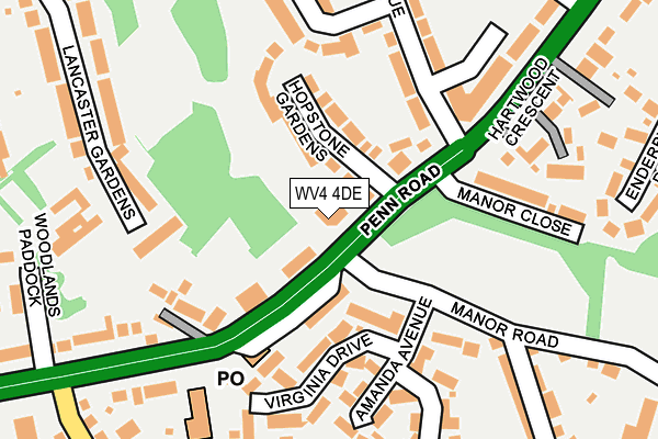
WV4 4DE is located in the Penn electoral ward, within the metropolitan district of Wolverhampton and the English Parliamentary constituency of Wolverhampton South West. The Sub Integrated Care Board (ICB) Location is NHS Black Country ICB - D2P2L and the police force is West Midlands. This postcode has been in use since January 1980.


GetTheData
Source: OS OpenMap – Local (Ordnance Survey)
Source: OS VectorMap District (Ordnance Survey)
Licence: Open Government Licence (requires attribution)
| Easting | 389687 |
| Northing | 295920 |
| Latitude | 52.561014 |
| Longitude | -2.153561 |
GetTheData
Source: Open Postcode Geo
Licence: Open Government Licence
| Country | England |
| Postcode District | WV4 |
| ➜ WV4 open data dashboard ➜ See where WV4 is on a map ➜ Where is Wolverhampton? | |
GetTheData
Source: Land Registry Price Paid Data
Licence: Open Government Licence
Elevation or altitude of WV4 4DE as distance above sea level:
| Metres | Feet | |
|---|---|---|
| Elevation | 150m | 492ft |
Elevation is measured from the approximate centre of the postcode, to the nearest point on an OS contour line from OS Terrain 50, which has contour spacing of ten vertical metres.
➜ How high above sea level am I? Find the elevation of your current position using your device's GPS.
GetTheData
Source: Open Postcode Elevation
Licence: Open Government Licence
| Ward | Penn |
| Constituency | Wolverhampton South West |
GetTheData
Source: ONS Postcode Database
Licence: Open Government Licence
| November 2023 | Criminal damage and arson | On or near St Catherine'S Crescent | 344m |
| October 2023 | Violence and sexual offences | On or near St Catherine'S Crescent | 344m |
| June 2023 | Burglary | On or near St Catherine'S Crescent | 344m |
| ➜ Get more crime data in our Crime section | |||
GetTheData
Source: data.police.uk
Licence: Open Government Licence
| Manor Rd (Penn Rd) | Penn | 41m |
| Manor Rd (Penn Rd) | Penn | 53m |
| Manor Rd (Penn Rd) | Penn | 124m |
| Pennhouse Ave (Penn Rd) | Penn | 148m |
| Swan Bank (Manor Rd) | Penn | 200m |
| Wolverhampton Station | 3.8km |
| Coseley Station | 4.9km |
GetTheData
Source: NaPTAN
Licence: Open Government Licence
GetTheData
Source: ONS Postcode Database
Licence: Open Government Licence


➜ Get more ratings from the Food Standards Agency
GetTheData
Source: Food Standards Agency
Licence: FSA terms & conditions
| Last Collection | |||
|---|---|---|---|
| Location | Mon-Fri | Sat | Distance |
| Pennhouse Avenue | 16:45 | 12:30 | 219m |
| Linton Road | 16:45 | 12:30 | 519m |
| Wynn Road | 16:45 | 12:15 | 638m |
GetTheData
Source: Dracos
Licence: Creative Commons Attribution-ShareAlike
| Facility | Distance |
|---|---|
| Penn Cricket Club (Closed) Mount Road, Penn, Wolverhampton Grass Pitches | 677m |
| Penn Hall School Vicarage Road, Penn, Wolverhampton Sports Hall | 718m |
| Windsor Avenue Playing Fields Pinfold Lane, Wolverhampton Grass Pitches | 727m |
GetTheData
Source: Active Places
Licence: Open Government Licence
| School | Phase of Education | Distance |
|---|---|---|
| Penn Hall School Vicarage Road, Penn, Wolverhampton, WV4 5HP | Not applicable | 716m |
| St Bartholomew's Church of England Primary School Sedgley Road, Penn, St Bartholomew's Ce Primary School, Wolverhampton, WV4 5LG | Primary | 802m |
| Woodfield Primary School Woodfield Avenue, Wolverhampton, WV4 4AG | Primary | 807m |
GetTheData
Source: Edubase
Licence: Open Government Licence
The below table lists the International Territorial Level (ITL) codes (formerly Nomenclature of Territorial Units for Statistics (NUTS) codes) and Local Administrative Units (LAU) codes for WV4 4DE:
| ITL 1 Code | Name |
|---|---|
| TLG | West Midlands (England) |
| ITL 2 Code | Name |
| TLG3 | West Midlands |
| ITL 3 Code | Name |
| TLG39 | Wolverhampton |
| LAU 1 Code | Name |
| E08000031 | Wolverhampton |
GetTheData
Source: ONS Postcode Directory
Licence: Open Government Licence
The below table lists the Census Output Area (OA), Lower Layer Super Output Area (LSOA), and Middle Layer Super Output Area (MSOA) for WV4 4DE:
| Code | Name | |
|---|---|---|
| OA | E00053094 | |
| LSOA | E01010513 | Wolverhampton 031A |
| MSOA | E02002179 | Wolverhampton 031 |
GetTheData
Source: ONS Postcode Directory
Licence: Open Government Licence
| WV4 4DB | Penn Road | 86m |
| WV4 4DD | Hopstone Gardens | 99m |
| WV4 5QF | Penn Road | 134m |
| WV4 4BG | Pennhouse Avenue | 145m |
| WV4 5PS | Virginia Drive | 154m |
| WV4 4DG | Woodland Cottages | 157m |
| WV4 5PP | Amanda Avenue | 170m |
| WV4 4BT | Grosvenor Park | 181m |
| WV4 5QR | Manor Close | 184m |
| WV4 5PR | Rebecca Gardens | 212m |
GetTheData
Source: Open Postcode Geo; Land Registry Price Paid Data
Licence: Open Government Licence