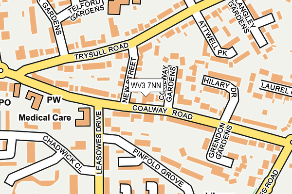
WV3 7NN lies on Coalway Road in Wolverhampton. WV3 7NN is located in the Merry Hill electoral ward, within the metropolitan district of Wolverhampton and the English Parliamentary constituency of Wolverhampton South West. The Sub Integrated Care Board (ICB) Location is NHS Black Country ICB - D2P2L and the police force is West Midlands. This postcode has been in use since January 1980.


GetTheData
Source: OS OpenMap – Local (Ordnance Survey)
Source: OS VectorMap District (Ordnance Survey)
Licence: Open Government Licence (requires attribution)
| Easting | 388749 |
| Northing | 296986 |
| Latitude | 52.570578 |
| Longitude | -2.167434 |
GetTheData
Source: Open Postcode Geo
Licence: Open Government Licence
| Street | Coalway Road |
| Town/City | Wolverhampton |
| Country | England |
| Postcode District | WV3 |
| ➜ WV3 open data dashboard ➜ See where WV3 is on a map ➜ Where is Wolverhampton? | |
GetTheData
Source: Land Registry Price Paid Data
Licence: Open Government Licence
Elevation or altitude of WV3 7NN as distance above sea level:
| Metres | Feet | |
|---|---|---|
| Elevation | 130m | 427ft |
Elevation is measured from the approximate centre of the postcode, to the nearest point on an OS contour line from OS Terrain 50, which has contour spacing of ten vertical metres.
➜ How high above sea level am I? Find the elevation of your current position using your device's GPS.
GetTheData
Source: Open Postcode Elevation
Licence: Open Government Licence
| Ward | Merry Hill |
| Constituency | Wolverhampton South West |
GetTheData
Source: ONS Postcode Database
Licence: Open Government Licence
| January 2024 | Shoplifting | On or near Supermarket | 367m |
| December 2023 | Violence and sexual offences | On or near Supermarket | 367m |
| December 2023 | Shoplifting | On or near Supermarket | 367m |
| ➜ Get more crime data in our Crime section | |||
GetTheData
Source: data.police.uk
Licence: Open Government Licence
| Attwell Park (Trysull Rd) | Merry Hill | 149m |
| Pinfold Grove (Leasowes Dr) | Merry Hill | 155m |
| Pinfold Grove (Leasowes Dr) | Merry Hill | 182m |
| Attwell Park (Trysull Rd) | Merry Hill | 184m |
| Five Ways (Trysull Rd) | Merry Hill | 220m |
| Wolverhampton Station | 3.8km |
GetTheData
Source: NaPTAN
Licence: Open Government Licence
| Percentage of properties with Next Generation Access | 100.0% |
| Percentage of properties with Superfast Broadband | 100.0% |
| Percentage of properties with Ultrafast Broadband | 100.0% |
| Percentage of properties with Full Fibre Broadband | 0.0% |
Superfast Broadband is between 30Mbps and 300Mbps
Ultrafast Broadband is > 300Mbps
| Percentage of properties unable to receive 2Mbps | 0.0% |
| Percentage of properties unable to receive 5Mbps | 0.0% |
| Percentage of properties unable to receive 10Mbps | 0.0% |
| Percentage of properties unable to receive 30Mbps | 0.0% |
GetTheData
Source: Ofcom
Licence: Ofcom Terms of Use (requires attribution)
GetTheData
Source: ONS Postcode Database
Licence: Open Government Licence


➜ Get more ratings from the Food Standards Agency
GetTheData
Source: Food Standards Agency
Licence: FSA terms & conditions
| Last Collection | |||
|---|---|---|---|
| Location | Mon-Fri | Sat | Distance |
| Trysull Road | 17:15 | 12:15 | 198m |
| Merry Hill Post Office | 17:15 | 12:30 | 272m |
| Oxbarn Avenue | 16:45 | 12:30 | 321m |
GetTheData
Source: Dracos
Licence: Creative Commons Attribution-ShareAlike
| Facility | Distance |
|---|---|
| St Michael's Catholic Primary Academy And Nursery Telford Gardens, Wolverhampton Grass Pitches | 221m |
| Warstones Primary School Warstones Road, Warstones Road, Penn, Wolverhampton Grass Pitches | 371m |
| Windsor Avenue Playing Fields Pinfold Lane, Wolverhampton Grass Pitches | 704m |
GetTheData
Source: Active Places
Licence: Open Government Licence
| School | Phase of Education | Distance |
|---|---|---|
| St Michael's Catholic Primary Academy and Nursery Telford Gardens, Merry Hill, Wolverhampton, WV3 7LE | Primary | 223m |
| Warstones Primary School Warstones Road, Penn, Wolverhampton, WV4 4LU | Primary | 373m |
| Springdale Primary School Warstones Drive, Penn, Wolverhampton, WV4 4NJ | Primary | 839m |
GetTheData
Source: Edubase
Licence: Open Government Licence
The below table lists the International Territorial Level (ITL) codes (formerly Nomenclature of Territorial Units for Statistics (NUTS) codes) and Local Administrative Units (LAU) codes for WV3 7NN:
| ITL 1 Code | Name |
|---|---|
| TLG | West Midlands (England) |
| ITL 2 Code | Name |
| TLG3 | West Midlands |
| ITL 3 Code | Name |
| TLG39 | Wolverhampton |
| LAU 1 Code | Name |
| E08000031 | Wolverhampton |
GetTheData
Source: ONS Postcode Directory
Licence: Open Government Licence
The below table lists the Census Output Area (OA), Lower Layer Super Output Area (LSOA), and Middle Layer Super Output Area (MSOA) for WV3 7NN:
| Code | Name | |
|---|---|---|
| OA | E00052951 | |
| LSOA | E01010488 | Wolverhampton 021B |
| MSOA | E02002169 | Wolverhampton 021 |
GetTheData
Source: ONS Postcode Directory
Licence: Open Government Licence
| WV3 7NW | New Street | 48m |
| WV3 7NL | Coalway Gardens | 78m |
| WV3 7JP | Trysull Road | 93m |
| WV4 4PT | Pinfold Grove | 111m |
| WV3 7NG | Coalway Road | 126m |
| WV3 7NP | Coalway Road | 145m |
| WV4 4PS | Pinfold Grove | 149m |
| WV3 7JR | Trysull Road | 149m |
| WV3 7NJ | Hilary Drive | 150m |
| WV4 4PU | Leasowes Drive | 166m |
GetTheData
Source: Open Postcode Geo; Land Registry Price Paid Data
Licence: Open Government Licence