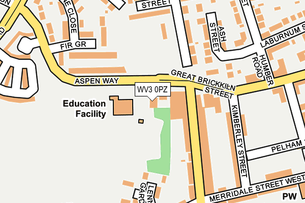
WV3 0PZ is located in the Graiseley electoral ward, within the metropolitan district of Wolverhampton and the English Parliamentary constituency of Wolverhampton South West. The Sub Integrated Care Board (ICB) Location is NHS Black Country ICB - D2P2L and the police force is West Midlands. This postcode has been in use since January 1980.


GetTheData
Source: OS OpenMap – Local (Ordnance Survey)
Source: OS VectorMap District (Ordnance Survey)
Licence: Open Government Licence (requires attribution)
| Easting | 390256 |
| Northing | 298111 |
| Latitude | 52.580721 |
| Longitude | -2.145233 |
GetTheData
Source: Open Postcode Geo
Licence: Open Government Licence
| Country | England |
| Postcode District | WV3 |
| ➜ WV3 open data dashboard ➜ See where WV3 is on a map ➜ Where is Wolverhampton? | |
GetTheData
Source: Land Registry Price Paid Data
Licence: Open Government Licence
Elevation or altitude of WV3 0PZ as distance above sea level:
| Metres | Feet | |
|---|---|---|
| Elevation | 130m | 427ft |
Elevation is measured from the approximate centre of the postcode, to the nearest point on an OS contour line from OS Terrain 50, which has contour spacing of ten vertical metres.
➜ How high above sea level am I? Find the elevation of your current position using your device's GPS.
GetTheData
Source: Open Postcode Elevation
Licence: Open Government Licence
| Ward | Graiseley |
| Constituency | Wolverhampton South West |
GetTheData
Source: ONS Postcode Database
Licence: Open Government Licence
| November 2023 | Public order | On or near Oak Street | 250m |
| October 2023 | Violence and sexual offences | On or near Oak Street | 250m |
| October 2023 | Burglary | On or near Downham Place | 498m |
| ➜ Get more crime data in our Crime section | |||
GetTheData
Source: data.police.uk
Licence: Open Government Licence
| Merridale Primary School (Owen Rd) | Bradmore | 71m |
| Kimberley St (Great Brickiln St) | Bradmore | 138m |
| Kimberley St (Great Brickiln St) | Bradmore | 146m |
| Lime St (Owen Rd) | Bradmore | 251m |
| Ashland St (Great Brickiln St) | Bradmore | 290m |
| Wolverhampton St George's (Midland Metro Stop) (Bilston St) | Wolverhampton | 1,470m |
| Wolverhampton Station | 1.9km |
| Bilbrook Station | 5.5km |
| Coseley Station | 5.7km |
GetTheData
Source: NaPTAN
Licence: Open Government Licence
GetTheData
Source: ONS Postcode Database
Licence: Open Government Licence


➜ Get more ratings from the Food Standards Agency
GetTheData
Source: Food Standards Agency
Licence: FSA terms & conditions
| Last Collection | |||
|---|---|---|---|
| Location | Mon-Fri | Sat | Distance |
| Great Brickkiln Street | 17:30 | 13:00 | 254m |
| Merridale Road Flats | 17:30 | 12:00 | 366m |
| Oak Street | 17:30 | 12:00 | 394m |
GetTheData
Source: Dracos
Licence: Creative Commons Attribution-ShareAlike
| Facility | Distance |
|---|---|
| Merridale Primary School Aspen Way, Aspen Way, Wolverhampton Grass Pitches | 60m |
| Firewalker Fitness And Martial Arts Salisbury Street, Wolverhampton Health and Fitness Gym, Studio | 421m |
| Gamesfield Green Playing Field Gamesfield Green, Wolverhampton Grass Pitches | 566m |
GetTheData
Source: Active Places
Licence: Open Government Licence
| School | Phase of Education | Distance |
|---|---|---|
| Merridale Primary School Aspen Way, Wolverhampton, WV3 0UP | Primary | 60m |
| Nishkam Primary School Wolverhampton Great Brickkiln Street, Wolverhampton, WV3 0PR | Primary | 411m |
| Bantock Primary School Aston Street, Penn Fields, Wolverhampton, WV3 0HY | Primary | 427m |
GetTheData
Source: Edubase
Licence: Open Government Licence
The below table lists the International Territorial Level (ITL) codes (formerly Nomenclature of Territorial Units for Statistics (NUTS) codes) and Local Administrative Units (LAU) codes for WV3 0PZ:
| ITL 1 Code | Name |
|---|---|
| TLG | West Midlands (England) |
| ITL 2 Code | Name |
| TLG3 | West Midlands |
| ITL 3 Code | Name |
| TLG39 | Wolverhampton |
| LAU 1 Code | Name |
| E08000031 | Wolverhampton |
GetTheData
Source: ONS Postcode Directory
Licence: Open Government Licence
The below table lists the Census Output Area (OA), Lower Layer Super Output Area (LSOA), and Middle Layer Super Output Area (MSOA) for WV3 0PZ:
| Code | Name | |
|---|---|---|
| OA | E00052867 | |
| LSOA | E01010470 | Wolverhampton 020E |
| MSOA | E02002168 | Wolverhampton 020 |
GetTheData
Source: ONS Postcode Directory
Licence: Open Government Licence
| WV3 0AL | Owen Road | 129m |
| WV3 0UP | Aspen Way | 134m |
| WV3 0AJ | Owen Road | 137m |
| WV3 0DF | Melbury Close | 141m |
| WV3 0UR | Fir Grove | 147m |
| WV3 0AQ | Oak Street | 157m |
| WV3 0DD | Ash Street | 167m |
| WV3 0AF | Elm Street | 172m |
| WV3 0RR | Lennox Gardens | 173m |
| WV3 0BP | Kimberley Street | 187m |
GetTheData
Source: Open Postcode Geo; Land Registry Price Paid Data
Licence: Open Government Licence