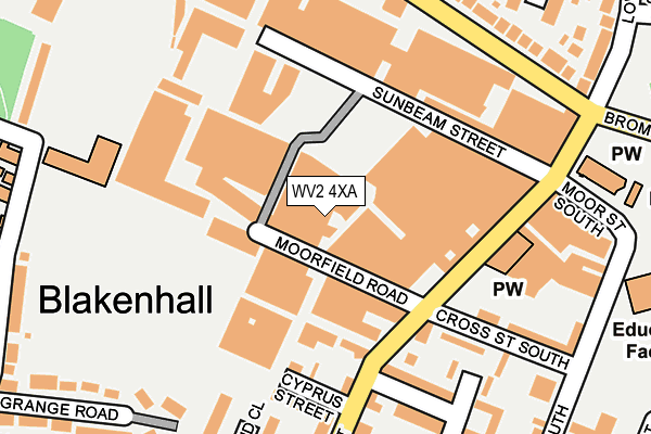
WV2 4XA is located in the Blakenhall electoral ward, within the metropolitan district of Wolverhampton and the English Parliamentary constituency of Wolverhampton South East. The Sub Integrated Care Board (ICB) Location is NHS Black Country ICB - D2P2L and the police force is West Midlands. This postcode has been in use since December 2000.


GetTheData
Source: OS OpenMap – Local (Ordnance Survey)
Source: OS VectorMap District (Ordnance Survey)
Licence: Open Government Licence (requires attribution)
| Easting | 391067 |
| Northing | 297133 |
| Latitude | 52.571943 |
| Longitude | -2.133237 |
GetTheData
Source: Open Postcode Geo
Licence: Open Government Licence
| Country | England |
| Postcode District | WV2 |
| ➜ WV2 open data dashboard ➜ See where WV2 is on a map ➜ Where is Wolverhampton? | |
GetTheData
Source: Land Registry Price Paid Data
Licence: Open Government Licence
Elevation or altitude of WV2 4XA as distance above sea level:
| Metres | Feet | |
|---|---|---|
| Elevation | 160m | 525ft |
Elevation is measured from the approximate centre of the postcode, to the nearest point on an OS contour line from OS Terrain 50, which has contour spacing of ten vertical metres.
➜ How high above sea level am I? Find the elevation of your current position using your device's GPS.
GetTheData
Source: Open Postcode Elevation
Licence: Open Government Licence
| Ward | Blakenhall |
| Constituency | Wolverhampton South East |
GetTheData
Source: ONS Postcode Database
Licence: Open Government Licence
| January 2024 | Violence and sexual offences | On or near Clayton Close | 313m |
| December 2023 | Public order | On or near Clayton Close | 313m |
| December 2023 | Other theft | On or near Clayton Close | 313m |
| ➜ Get more crime data in our Crime section | |||
GetTheData
Source: data.police.uk
Licence: Open Government Licence
| Torrington Sports And Social Club (Upper Villiers St) | Blakenhall | 133m |
| Torrington Sports And Social Club (Upper Villiers St) | Blakenhall | 171m |
| Chetwynd Rd (Upper Villiers St) | Blakenhall | 204m |
| Industrial Estates (Marston Rd) | Blakenhall | 215m |
| Industrial Estates (Marston Rd) | Blakenhall | 224m |
| Wolverhampton St George's (Midland Metro Stop) (Bilston St) | Wolverhampton | 1,480m |
| The Royal (Midland Metro Stop) (Bilston St) | Wolverhampton | 1,488m |
| Wolverhampton Station | 2km |
| Coseley Station | 4.4km |
| Tipton Station | 6.5km |
GetTheData
Source: NaPTAN
Licence: Open Government Licence
GetTheData
Source: ONS Postcode Database
Licence: Open Government Licence


➜ Get more ratings from the Food Standards Agency
GetTheData
Source: Food Standards Agency
Licence: FSA terms & conditions
| Last Collection | |||
|---|---|---|---|
| Location | Mon-Fri | Sat | Distance |
| Marston Road | 17:15 | 13:00 | 231m |
| Blakenhall Post Office | 17:15 | 12:00 | 301m |
| Hilton Road | 16:45 | 12:45 | 508m |
GetTheData
Source: Dracos
Licence: Creative Commons Attribution-ShareAlike
| Facility | Distance |
|---|---|
| St Lukes C Of E Primary School (Wolverhampton) Park Street South, Park Street South, Wolverhampton Grass Pitches | 321m |
| The Royal Wolverhampton School Penn Road, Wolverhampton Swimming Pool, Sports Hall, Artificial Grass Pitch, Grass Pitches, Studio | 333m |
| Bob Jones Community Hub Bromley Street, Wolverhampton Health and Fitness Gym, Sports Hall | 353m |
GetTheData
Source: Active Places
Licence: Open Government Licence
| School | Phase of Education | Distance |
|---|---|---|
| St Luke's Church of England Aided Primary School Park Street South, Blakenhall, Wolverhampton, WV2 3AE | Primary | 294m |
| The Royal School, Wolverhampton Penn Road, Wolverhampton, WV3 0EG | All-through | 333m |
| Graiseley Primary School Pool Street, Graiseley Hill, Wolverhampton, WV2 4NE | Primary | 496m |
GetTheData
Source: Edubase
Licence: Open Government Licence
The below table lists the International Territorial Level (ITL) codes (formerly Nomenclature of Territorial Units for Statistics (NUTS) codes) and Local Administrative Units (LAU) codes for WV2 4XA:
| ITL 1 Code | Name |
|---|---|
| TLG | West Midlands (England) |
| ITL 2 Code | Name |
| TLG3 | West Midlands |
| ITL 3 Code | Name |
| TLG39 | Wolverhampton |
| LAU 1 Code | Name |
| E08000031 | Wolverhampton |
GetTheData
Source: ONS Postcode Directory
Licence: Open Government Licence
The below table lists the Census Output Area (OA), Lower Layer Super Output Area (LSOA), and Middle Layer Super Output Area (MSOA) for WV2 4XA:
| Code | Name | |
|---|---|---|
| OA | E00052677 | |
| LSOA | E01010429 | Wolverhampton 035C |
| MSOA | E02006894 | Wolverhampton 035 |
GetTheData
Source: ONS Postcode Directory
Licence: Open Government Licence
| WV2 4PA | Cyprus Street | 173m |
| WV2 4NU | Upper Villiers Street | 192m |
| WV2 3JQ | Cross St South | 202m |
| WV2 4PQ | Bromwynd Close | 225m |
| WV2 4NL | Marston Road | 238m |
| WV2 4PL | Grange Road | 254m |
| WV2 4NJ | Marston Road | 256m |
| WV2 3JD | Fowler Street | 270m |
| WV3 0ED | Penn Road | 297m |
| WV2 3JB | Fowler Street | 298m |
GetTheData
Source: Open Postcode Geo; Land Registry Price Paid Data
Licence: Open Government Licence