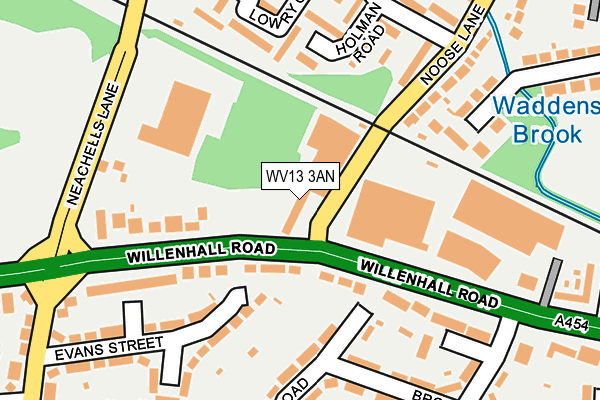
WV13 3AN is located in the East Park electoral ward, within the metropolitan district of Wolverhampton and the English Parliamentary constituency of Wolverhampton South East. The Sub Integrated Care Board (ICB) Location is NHS Black Country ICB - D2P2L and the police force is West Midlands. This postcode has been in use since November 2013.


GetTheData
Source: OS OpenMap – Local (Ordnance Survey)
Source: OS VectorMap District (Ordnance Survey)
Licence: Open Government Licence (requires attribution)
| Easting | 394984 |
| Northing | 298517 |
| Latitude | 52.584452 |
| Longitude | -2.075458 |
GetTheData
Source: Open Postcode Geo
Licence: Open Government Licence
| Country | England |
| Postcode District | WV13 |
| ➜ WV13 open data dashboard ➜ See where WV13 is on a map ➜ Where is Wolverhampton? | |
GetTheData
Source: Land Registry Price Paid Data
Licence: Open Government Licence
Elevation or altitude of WV13 3AN as distance above sea level:
| Metres | Feet | |
|---|---|---|
| Elevation | 130m | 427ft |
Elevation is measured from the approximate centre of the postcode, to the nearest point on an OS contour line from OS Terrain 50, which has contour spacing of ten vertical metres.
➜ How high above sea level am I? Find the elevation of your current position using your device's GPS.
GetTheData
Source: Open Postcode Elevation
Licence: Open Government Licence
| Ward | East Park |
| Constituency | Wolverhampton South East |
GetTheData
Source: ONS Postcode Database
Licence: Open Government Licence
| January 2024 | Public order | On or near Holman Close | 454m |
| January 2024 | Anti-social behaviour | On or near Holman Close | 454m |
| December 2023 | Drugs | On or near Holman Close | 454m |
| ➜ Get more crime data in our Crime section | |||
GetTheData
Source: data.police.uk
Licence: Open Government Licence
| Noose Lane (Willenhall Rd) | Portobello | 87m |
| Noose Lane (Willenhall Rd) | Portobello | 199m |
| Lowry Close (Noose Cres) | Little London | 263m |
| Lowry Close (Noose Cres) | Little London | 281m |
| Evans St (Moseley Rd) | Portobello | 288m |
| Wolverhampton Station | 3km |
| Coseley Station | 4.4km |
| Bloxwich Station | 5.7km |
GetTheData
Source: NaPTAN
Licence: Open Government Licence
GetTheData
Source: ONS Postcode Database
Licence: Open Government Licence


➜ Get more ratings from the Food Standards Agency
GetTheData
Source: Food Standards Agency
Licence: FSA terms & conditions
| Last Collection | |||
|---|---|---|---|
| Location | Mon-Fri | Sat | Distance |
| New Road | 17:30 | 12:00 | 1,228m |
| Stafford Street | 17:30 | 12:00 | 1,339m |
| Lichfield Street Post Office | 19:30 | 12:30 | 1,407m |
GetTheData
Source: Dracos
Licence: Creative Commons Attribution-ShareAlike
| Facility | Distance |
|---|---|
| Stow Heath Primary School Hill Road, Willenhall Grass Pitches | 364m |
| Josiah Parkes Sports Ground (Closed) School Street, Willenhall Grass Pitches | 627m |
| Willenhall Memorial Park Noose Lane, Willenhall Grass Pitches, Outdoor Tennis Courts | 798m |
GetTheData
Source: Active Places
Licence: Open Government Licence
| School | Phase of Education | Distance |
|---|---|---|
| Stow Heath Primary School Hill Road, Portobello, Willenhall, WV13 3TT | Primary | 395m |
| St Matthias School Deans Road, Wolverhampton, WV1 2BH | Secondary | 827m |
| Moseley Park Holland Road, Bilston, WV14 6LU | Secondary | 984m |
GetTheData
Source: Edubase
Licence: Open Government Licence
The below table lists the International Territorial Level (ITL) codes (formerly Nomenclature of Territorial Units for Statistics (NUTS) codes) and Local Administrative Units (LAU) codes for WV13 3AN:
| ITL 1 Code | Name |
|---|---|
| TLG | West Midlands (England) |
| ITL 2 Code | Name |
| TLG3 | West Midlands |
| ITL 3 Code | Name |
| TLG39 | Wolverhampton |
| LAU 1 Code | Name |
| E08000031 | Wolverhampton |
GetTheData
Source: ONS Postcode Directory
Licence: Open Government Licence
The below table lists the Census Output Area (OA), Lower Layer Super Output Area (LSOA), and Middle Layer Super Output Area (MSOA) for WV13 3AN:
| Code | Name | |
|---|---|---|
| OA | E00052737 | |
| LSOA | E01010446 | Wolverhampton 023E |
| MSOA | E02002171 | Wolverhampton 023 |
GetTheData
Source: ONS Postcode Directory
Licence: Open Government Licence
| WV13 3QZ | Willenhall Road | 69m |
| WV13 3LP | Willenhall Road | 116m |
| WV13 3AU | Lowry Close | 170m |
| WV13 3AS | Holman Road | 171m |
| WV13 3BP | Noose Lane | 181m |
| WV13 3QU | Willenhall Road | 197m |
| WV13 3UH | Brook Road | 200m |
| WV13 3LR | Neachells Lane | 201m |
| WV13 3UD | Vaughan Road | 205m |
| WV13 3BX | Noose Lane | 219m |
GetTheData
Source: Open Postcode Geo; Land Registry Price Paid Data
Licence: Open Government Licence