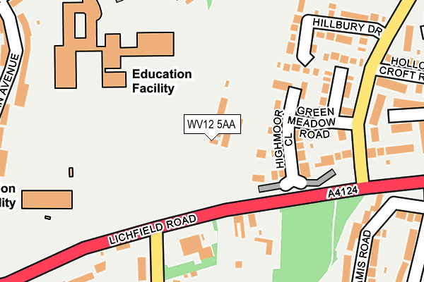
WV12 5AA is located in the Wednesfield North electoral ward, within the metropolitan district of Wolverhampton and the English Parliamentary constituency of Wolverhampton North East. The Sub Integrated Care Board (ICB) Location is NHS Black Country ICB - D2P2L and the police force is West Midlands. This postcode has been in use since January 1980.


GetTheData
Source: OS OpenMap – Local (Ordnance Survey)
Source: OS VectorMap District (Ordnance Survey)
Licence: Open Government Licence (requires attribution)
| Easting | 396636 |
| Northing | 301382 |
| Latitude | 52.610205 |
| Longitude | -2.051112 |
GetTheData
Source: Open Postcode Geo
Licence: Open Government Licence
| Country | England |
| Postcode District | WV12 |
| ➜ WV12 open data dashboard ➜ See where WV12 is on a map ➜ Where is Wolverhampton? | |
GetTheData
Source: Land Registry Price Paid Data
Licence: Open Government Licence
Elevation or altitude of WV12 5AA as distance above sea level:
| Metres | Feet | |
|---|---|---|
| Elevation | 150m | 492ft |
Elevation is measured from the approximate centre of the postcode, to the nearest point on an OS contour line from OS Terrain 50, which has contour spacing of ten vertical metres.
➜ How high above sea level am I? Find the elevation of your current position using your device's GPS.
GetTheData
Source: Open Postcode Elevation
Licence: Open Government Licence
| Ward | Wednesfield North |
| Constituency | Wolverhampton North East |
GetTheData
Source: ONS Postcode Database
Licence: Open Government Licence
| January 2024 | Violence and sexual offences | On or near Gorse Road | 397m |
| December 2023 | Violence and sexual offences | On or near Gorse Road | 397m |
| December 2023 | Violence and sexual offences | On or near Gorse Road | 397m |
| ➜ Get more crime data in our Crime section | |||
GetTheData
Source: data.police.uk
Licence: Open Government Licence
| Broad Lane North (Lichfield Rd) | Ashmore Park | 111m |
| Broad Lane North (Lichfield Rd) | Ashmore Park | 124m |
| Sandringham Avenue (Lichfield Rd) | Coppice Farm | 261m |
| Greenmeadow Rd (Coppice Farm Way) | Coppice Farm | 261m |
| Greenmeadow Rd (Coppice Farm Way) | Coppice Farm | 281m |
| Bloxwich North Station | 2.8km |
| Bloxwich Station | 2.8km |
| Wolverhampton Station | 5.3km |
GetTheData
Source: NaPTAN
Licence: Open Government Licence
GetTheData
Source: ONS Postcode Database
Licence: Open Government Licence


➜ Get more ratings from the Food Standards Agency
GetTheData
Source: Food Standards Agency
Licence: FSA terms & conditions
| Last Collection | |||
|---|---|---|---|
| Location | Mon-Fri | Sat | Distance |
| Sandringham Avenue | 17:15 | 12:00 | 333m |
| Ashmore Park Post Office | 17:15 | 12:00 | 748m |
| Perry Hall Post Office | 16:45 | 12:00 | 864m |
GetTheData
Source: Dracos
Licence: Creative Commons Attribution-ShareAlike
| Facility | Distance |
|---|---|
| Coppice Performing Arts School Ecclestone Road, Wolverhampton Sports Hall, Swimming Pool, Grass Pitches, Studio, Health and Fitness Gym, Artificial Grass Pitch | 248m |
| Oak Meadow Primary School Ryan Avenue, Ashmore Park, Wolverhampton Grass Pitches | 249m |
| St Albans Ce Academy (Wolverhampton) St. Albans Close, Wolverhampton Grass Pitches | 606m |
GetTheData
Source: Active Places
Licence: Open Government Licence
| School | Phase of Education | Distance |
|---|---|---|
| Coppice Performing Arts School Ecclestone Road, Wolverhampton, WV11 2QE | Secondary | 248m |
| Oak Meadow Primary School Ryan Avenue, Ashmore Park, Wednesfield, Wolverhampton, WV11 2QQ | Primary | 323m |
| St Alban's Church of England Primary Academy St. Albans Close, Ashmore Park, Wolverhampton, WV11 2PF | Primary | 606m |
GetTheData
Source: Edubase
Licence: Open Government Licence
The below table lists the International Territorial Level (ITL) codes (formerly Nomenclature of Territorial Units for Statistics (NUTS) codes) and Local Administrative Units (LAU) codes for WV12 5AA:
| ITL 1 Code | Name |
|---|---|
| TLG | West Midlands (England) |
| ITL 2 Code | Name |
| TLG3 | West Midlands |
| ITL 3 Code | Name |
| TLG39 | Wolverhampton |
| LAU 1 Code | Name |
| E08000031 | Wolverhampton |
GetTheData
Source: ONS Postcode Directory
Licence: Open Government Licence
The below table lists the Census Output Area (OA), Lower Layer Super Output Area (LSOA), and Middle Layer Super Output Area (MSOA) for WV12 5AA:
| Code | Name | |
|---|---|---|
| OA | E00053288 | |
| LSOA | E01010556 | Wolverhampton 005B |
| MSOA | E02002153 | Wolverhampton 005 |
GetTheData
Source: ONS Postcode Directory
Licence: Open Government Licence
| WV12 5UU | Highmoor Close | 120m |
| WV12 5UY | Green Meadow Road | 163m |
| WV12 5UX | Grazewood Close | 185m |
| WV12 5UT | Hillbury Drive | 222m |
| WV12 5UB | Broad Lane North | 247m |
| WV12 5YU | Roundlea Close | 258m |
| WV12 5UD | Len Davis Road | 285m |
| WV12 5ST | Glamis Road | 298m |
| WV11 2QD | Reynolds Walk | 300m |
| WV12 5YT | Meadow Grange Drive | 300m |
GetTheData
Source: Open Postcode Geo; Land Registry Price Paid Data
Licence: Open Government Licence