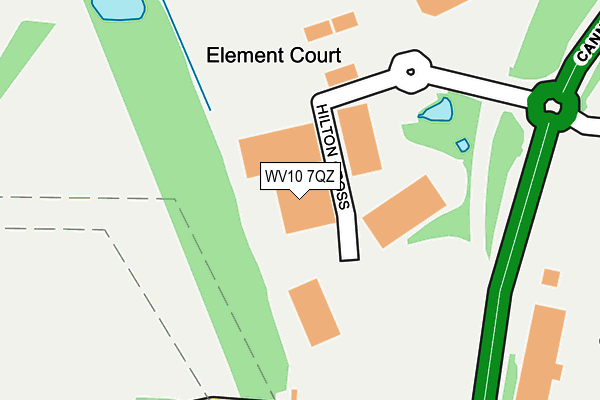
WV10 7QZ is located in the Featherstone, Sharehill & Saredon electoral ward, within the local authority district of South Staffordshire and the English Parliamentary constituency of South Staffordshire. The Sub Integrated Care Board (ICB) Location is NHS Staffordshire and Stoke-on-Trent ICB - 05Q and the police force is Staffordshire. This postcode has been in use since June 1997.


GetTheData
Source: OS OpenMap – Local (Ordnance Survey)
Source: OS VectorMap District (Ordnance Survey)
Licence: Open Government Licence (requires attribution)
| Easting | 393792 |
| Northing | 304314 |
| Latitude | 52.636553 |
| Longitude | -2.093162 |
GetTheData
Source: Open Postcode Geo
Licence: Open Government Licence
| Country | England |
| Postcode District | WV10 |
| ➜ WV10 open data dashboard ➜ See where WV10 is on a map | |
GetTheData
Source: Land Registry Price Paid Data
Licence: Open Government Licence
Elevation or altitude of WV10 7QZ as distance above sea level:
| Metres | Feet | |
|---|---|---|
| Elevation | 140m | 459ft |
Elevation is measured from the approximate centre of the postcode, to the nearest point on an OS contour line from OS Terrain 50, which has contour spacing of ten vertical metres.
➜ How high above sea level am I? Find the elevation of your current position using your device's GPS.
GetTheData
Source: Open Postcode Elevation
Licence: Open Government Licence
| Ward | Featherstone, Sharehill & Saredon |
| Constituency | South Staffordshire |
GetTheData
Source: ONS Postcode Database
Licence: Open Government Licence
| June 2022 | Vehicle crime | On or near A460 | 187m |
| December 2021 | Burglary | On or near A460 | 187m |
| November 2021 | Drugs | On or near A460 | 187m |
| ➜ Get more crime data in our Crime section | |||
GetTheData
Source: data.police.uk
Licence: Open Government Licence
| Hilton Services (Cannock Road) | Featherstone | 164m |
| Hilton Services (Cannock Road) | Featherstone | 246m |
| Garage (Cannock Road) | Westcroft | 532m |
| Garage (Cannock Road) | Westcroft | 553m |
| Whitgreave School (The Avenue) | Featherstone | 757m |
| Landywood Station | 5.4km |
GetTheData
Source: NaPTAN
Licence: Open Government Licence
GetTheData
Source: ONS Postcode Database
Licence: Open Government Licence


➜ Get more ratings from the Food Standards Agency
GetTheData
Source: Food Standards Agency
Licence: FSA terms & conditions
| Last Collection | |||
|---|---|---|---|
| Location | Mon-Fri | Sat | Distance |
| St Annes Road | 17:00 | 13:00 | 1,070m |
| Abbeyfield Road | 17:00 | 12:30 | 1,195m |
| Park Village Post Office | 17:30 | 12:00 | 1,497m |
GetTheData
Source: Dracos
Licence: Creative Commons Attribution-ShareAlike
| Facility | Distance |
|---|---|
| Featherstone Academy (Whitgreave) The Avenue, Featherstone, Wolverhampton Grass Pitches | 712m |
| Greenfield Golf Club Greenfield Lane, Greenfield Lane, Wolverhampton Golf | 1.4km |
| Hmp Featherstone New Road, Featherstone, Wolverhampton Artificial Grass Pitch, Grass Pitches, Sports Hall | 1.4km |
GetTheData
Source: Active Places
Licence: Open Government Licence
| School | Phase of Education | Distance |
|---|---|---|
| Featherstone Academy The Avenue, Featherstone, Wolverhampton, WV10 7AS | Primary | 724m |
| Westcroft School Greenacres Avenue, Underhill, Wolverhampton, WV10 8NZ | Not applicable | 1.7km |
| Berrybrook Primary School Greenacres Avenue, Underhill Estate, Wolverhampton, WV10 8NZ | Primary | 1.9km |
GetTheData
Source: Edubase
Licence: Open Government Licence
The below table lists the International Territorial Level (ITL) codes (formerly Nomenclature of Territorial Units for Statistics (NUTS) codes) and Local Administrative Units (LAU) codes for WV10 7QZ:
| ITL 1 Code | Name |
|---|---|
| TLG | West Midlands (England) |
| ITL 2 Code | Name |
| TLG2 | Shropshire and Staffordshire |
| ITL 3 Code | Name |
| TLG24 | Staffordshire CC |
| LAU 1 Code | Name |
| E07000196 | South Staffordshire |
GetTheData
Source: ONS Postcode Directory
Licence: Open Government Licence
The below table lists the Census Output Area (OA), Lower Layer Super Output Area (LSOA), and Middle Layer Super Output Area (MSOA) for WV10 7QZ:
| Code | Name | |
|---|---|---|
| OA | E00151000 | |
| LSOA | E01029637 | South Staffordshire 006D |
| MSOA | E02006179 | South Staffordshire 006 |
GetTheData
Source: ONS Postcode Directory
Licence: Open Government Licence
| WV11 2BE | Hilton Main Industrial Estate | 353m |
| WV10 8QU | Cannock Road | 560m |
| WV10 7BG | Brookhouse Close | 637m |
| WV10 7BJ | Whilmot Close | 660m |
| WV10 7BQ | Penderell Close | 681m |
| WV10 7AP | Whitgreave Avenue | 697m |
| WV10 7AU | South Crescent | 712m |
| WV10 7BH | Huddlestone Close | 714m |
| WV10 7BL | Jackson Close | 720m |
| WV10 8QT | Cannock Road | 729m |
GetTheData
Source: Open Postcode Geo; Land Registry Price Paid Data
Licence: Open Government Licence