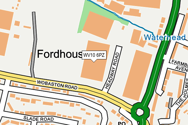
WV10 6PZ is located in the Bushbury North electoral ward, within the metropolitan district of Wolverhampton and the English Parliamentary constituency of Wolverhampton North East. The Sub Integrated Care Board (ICB) Location is NHS Black Country ICB - D2P2L and the police force is West Midlands. This postcode has been in use since June 2000.


GetTheData
Source: OS OpenMap – Local (Ordnance Survey)
Source: OS VectorMap District (Ordnance Survey)
Licence: Open Government Licence (requires attribution)
| Easting | 391490 |
| Northing | 303471 |
| Latitude | 52.628943 |
| Longitude | -2.127156 |
GetTheData
Source: Open Postcode Geo
Licence: Open Government Licence
| Country | England |
| Postcode District | WV10 |
| ➜ WV10 open data dashboard ➜ See where WV10 is on a map ➜ Where is Wolverhampton? | |
GetTheData
Source: Land Registry Price Paid Data
Licence: Open Government Licence
Elevation or altitude of WV10 6PZ as distance above sea level:
| Metres | Feet | |
|---|---|---|
| Elevation | 110m | 361ft |
Elevation is measured from the approximate centre of the postcode, to the nearest point on an OS contour line from OS Terrain 50, which has contour spacing of ten vertical metres.
➜ How high above sea level am I? Find the elevation of your current position using your device's GPS.
GetTheData
Source: Open Postcode Elevation
Licence: Open Government Licence
| Ward | Bushbury North |
| Constituency | Wolverhampton North East |
GetTheData
Source: ONS Postcode Database
Licence: Open Government Licence
| September 2023 | Violence and sexual offences | On or near Romsey Road | 330m |
| September 2023 | Violence and sexual offences | On or near Romsey Road | 330m |
| September 2023 | Anti-social behaviour | On or near Romsey Road | 330m |
| ➜ Get more crime data in our Crime section | |||
GetTheData
Source: data.police.uk
Licence: Open Government Licence
| Farnbrook Ave (Stafford Rd) | Fordhouses | 54m |
| Stafford Rd (Wobaston Rd) | Fordhouses | 95m |
| Stafford Rd (Wobaston Rd) | Fordhouses | 108m |
| Bee Lane (Stafford Rd) | Fordhouses | 220m |
| Bee Lane (Stafford Rd) | Fordhouses | 225m |
| Bilbrook Station | 4km |
| Wolverhampton Station | 4.6km |
GetTheData
Source: NaPTAN
Licence: Open Government Licence
GetTheData
Source: ONS Postcode Database
Licence: Open Government Licence


➜ Get more ratings from the Food Standards Agency
GetTheData
Source: Food Standards Agency
Licence: FSA terms & conditions
| Last Collection | |||
|---|---|---|---|
| Location | Mon-Fri | Sat | Distance |
| Farmbrook Avenue | 16:45 | 12:00 | 126m |
| Fordhouses Post Office | 18:00 | 12:15 | 141m |
| Ireton Road | 17:00 | 12:00 | 687m |
GetTheData
Source: Dracos
Licence: Creative Commons Attribution-ShareAlike
| Facility | Distance |
|---|---|
| Utc Collins Sports Ground Stratford Road, Fordhouses, Wolverhampton Grass Pitches | 480m |
| Bee Lane Playing Field Bee Lane, Wolverhampton Grass Pitches | 523m |
| Jack Threlfall Memorial Ground Wobaston Road, Wolverhampton Grass Pitches | 756m |
GetTheData
Source: Active Places
Licence: Open Government Licence
| School | Phase of Education | Distance |
|---|---|---|
| St Anthony's Catholic Primary Academy Stafford Road, Fordhouses, Wolverhampton, WV10 6NW | Primary | 336m |
| Elston Hall Primary School Stafford Road, Fordhouses, Wolverhampton, WV10 6NN | Primary | 646m |
| Ormiston NEW Academy Marsh Lane, Fordhouses, Wolverhampton, WV10 6SE | Secondary | 978m |
GetTheData
Source: Edubase
Licence: Open Government Licence
The below table lists the International Territorial Level (ITL) codes (formerly Nomenclature of Territorial Units for Statistics (NUTS) codes) and Local Administrative Units (LAU) codes for WV10 6PZ:
| ITL 1 Code | Name |
|---|---|
| TLG | West Midlands (England) |
| ITL 2 Code | Name |
| TLG3 | West Midlands |
| ITL 3 Code | Name |
| TLG39 | Wolverhampton |
| LAU 1 Code | Name |
| E08000031 | Wolverhampton |
GetTheData
Source: ONS Postcode Directory
Licence: Open Government Licence
The below table lists the Census Output Area (OA), Lower Layer Super Output Area (LSOA), and Middle Layer Super Output Area (MSOA) for WV10 6PZ:
| Code | Name | |
|---|---|---|
| OA | E00053026 | |
| LSOA | E01010495 | Wolverhampton 002A |
| MSOA | E02002150 | Wolverhampton 002 |
GetTheData
Source: ONS Postcode Directory
Licence: Open Government Licence
| WV10 6NR | Stafford Road | 103m |
| WV10 6QQ | Wobaston Road | 128m |
| WV10 6NG | Vine Close | 140m |
| WV10 6NF | The Holmes | 167m |
| WV10 7EG | Stafford Road | 189m |
| WV10 6NE | Farmbrook Avenue | 199m |
| WV10 6LT | Milldale Road | 204m |
| WV10 6LD | Bee Lane | 212m |
| WV10 6EY | Winchester Road | 221m |
| WV10 6LJ | Oriel Drive | 223m |
GetTheData
Source: Open Postcode Geo; Land Registry Price Paid Data
Licence: Open Government Licence