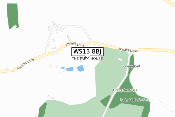
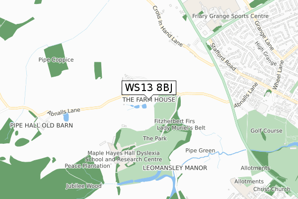
WS13 8BJ lies on Darwin Park in Lichfield. WS13 8BJ is located in the Highfield electoral ward, within the local authority district of Lichfield and the English Parliamentary constituency of Lichfield. The Sub Integrated Care Board (ICB) Location is NHS Staffordshire and Stoke-on-Trent ICB - 05Q and the police force is Staffordshire. This postcode has been in use since January 1980.


GetTheData
Source: OS Open Zoomstack (Ordnance Survey)
Licence: Open Government Licence (requires attribution)
Attribution: Contains OS data © Crown copyright and database right 2024
Source: Open Postcode Geo
Licence: Open Government Licence (requires attribution)
Attribution: Contains OS data © Crown copyright and database right 2024; Contains Royal Mail data © Royal Mail copyright and database right 2024; Source: Office for National Statistics licensed under the Open Government Licence v.3.0
| Easting | 409856 |
| Northing | 310060 |
| Latitude | 52.688141 |
| Longitude | -1.855627 |
GetTheData
Source: Open Postcode Geo
Licence: Open Government Licence
| Street | Darwin Park |
| Town/City | Lichfield |
| Country | England |
| Postcode District | WS13 |
| ➜ WS13 open data dashboard ➜ See where WS13 is on a map | |
GetTheData
Source: Land Registry Price Paid Data
Licence: Open Government Licence
Elevation or altitude of WS13 8BJ as distance above sea level:
| Metres | Feet | |
|---|---|---|
| Elevation | 100m | 328ft |
Elevation is measured from the approximate centre of the postcode, to the nearest point on an OS contour line from OS Terrain 50, which has contour spacing of ten vertical metres.
➜ How high above sea level am I? Find the elevation of your current position using your device's GPS.
GetTheData
Source: Open Postcode Elevation
Licence: Open Government Licence
| Ward | Highfield |
| Constituency | Lichfield |
GetTheData
Source: ONS Postcode Database
Licence: Open Government Licence
| Kean Close (Stafford Road) | Christ Church | 695m |
| Kean Close (Stafford Road) | Christ Church | 707m |
| Lyn Avenue (Stafford Road) | Christ Church | 709m |
| Lyn Avenue (Stafford Road) | Christ Church | 729m |
| Eastern Avenue (Stafford Road) | Christ Church | 738m |
| Lichfield City Station | 2.2km |
| Lichfield Trent Valley High Level Station | 3.7km |
| Lichfield Trent Valley Station | 3.7km |
GetTheData
Source: NaPTAN
Licence: Open Government Licence
| Percentage of properties with Next Generation Access | 100.0% |
| Percentage of properties with Superfast Broadband | 16.7% |
| Percentage of properties with Ultrafast Broadband | 0.0% |
| Percentage of properties with Full Fibre Broadband | 0.0% |
Superfast Broadband is between 30Mbps and 300Mbps
Ultrafast Broadband is > 300Mbps
| Percentage of properties unable to receive 2Mbps | 0.0% |
| Percentage of properties unable to receive 5Mbps | 0.0% |
| Percentage of properties unable to receive 10Mbps | 0.0% |
| Percentage of properties unable to receive 30Mbps | 83.3% |
GetTheData
Source: Ofcom
Licence: Ofcom Terms of Use (requires attribution)
Estimated total energy consumption in WS13 8BJ by fuel type, 2015.
| Consumption (kWh) | 46,964 |
|---|---|
| Meter count | 6 |
| Mean (kWh/meter) | 7,827 |
| Median (kWh/meter) | 6,270 |
GetTheData
Source: Postcode level gas estimates: 2015 (experimental)
Source: Postcode level electricity estimates: 2015 (experimental)
Licence: Open Government Licence
GetTheData
Source: ONS Postcode Database
Licence: Open Government Licence


➜ Get more ratings from the Food Standards Agency
GetTheData
Source: Food Standards Agency
Licence: FSA terms & conditions
| Last Collection | |||
|---|---|---|---|
| Location | Mon-Fri | Sat | Distance |
| Stafford Road | 17:30 | 11:00 | 739m |
| Nursery Croft | 17:30 | 11:00 | 987m |
| Safeway | 17:30 | 12:00 | 1,023m |
GetTheData
Source: Dracos
Licence: Creative Commons Attribution-ShareAlike
| Facility | Distance |
|---|---|
| Maple Hayes Hall School For Dyslexics Abnalls Lane, Lichfield Grass Pitches | 497m |
| The Bypass Stafford Road, Lichfield Grass Pitches | 801m |
| The Friary School Eastern Avenue, Lichfield Sports Hall, Artificial Grass Pitch, Grass Pitches | 894m |
GetTheData
Source: Active Places
Licence: Open Government Licence
| School | Phase of Education | Distance |
|---|---|---|
| Maple Hayes Hall School Abnalls Lane, Lichfield, WS13 8BL | Not applicable | 489m |
| The Friary School Eastern Avenue, Lichfield, WS13 7EW | Secondary | 917m |
| Christ Church CofE (C) Primary School Christ Church Lane, Lichfield, WS13 8AY | Primary | 1.2km |
GetTheData
Source: Edubase
Licence: Open Government Licence
The below table lists the International Territorial Level (ITL) codes (formerly Nomenclature of Territorial Units for Statistics (NUTS) codes) and Local Administrative Units (LAU) codes for WS13 8BJ:
| ITL 1 Code | Name |
|---|---|
| TLG | West Midlands (England) |
| ITL 2 Code | Name |
| TLG2 | Shropshire and Staffordshire |
| ITL 3 Code | Name |
| TLG24 | Staffordshire CC |
| LAU 1 Code | Name |
| E07000194 | Lichfield |
GetTheData
Source: ONS Postcode Directory
Licence: Open Government Licence
The below table lists the Census Output Area (OA), Lower Layer Super Output Area (LSOA), and Middle Layer Super Output Area (MSOA) for WS13 8BJ:
| Code | Name | |
|---|---|---|
| OA | E00168389 | |
| LSOA | E01029508 | Lichfield 003C |
| MSOA | E02006148 | Lichfield 003 |
GetTheData
Source: ONS Postcode Directory
Licence: Open Government Licence
| WS13 8BN | Abnalls Lane | 221m |
| WS13 8EA | Cross In Hand Lane | 533m |
| WS13 8JH | Walsall Road | 616m |
| WS13 7BY | Cross In Hand Lane | 705m |
| WS13 7BT | Hayes View | 715m |
| WS13 7BU | Lynfield Road | 716m |
| WS13 7BZ | Stafford Road | 734m |
| WS13 7EL | Kean Close | 758m |
| WS13 7BP | Abnalls Croft | 763m |
| WS13 7BX | Pinfold Road | 769m |
GetTheData
Source: Open Postcode Geo; Land Registry Price Paid Data
Licence: Open Government Licence