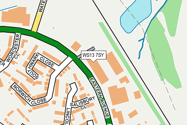
WS13 7SY is located in the Curborough electoral ward, within the local authority district of Lichfield and the English Parliamentary constituency of Lichfield. The Sub Integrated Care Board (ICB) Location is NHS Staffordshire and Stoke-on-Trent ICB - 05Q and the police force is Staffordshire. This postcode has been in use since September 2010.


GetTheData
Source: OS OpenMap – Local (Ordnance Survey)
Source: OS VectorMap District (Ordnance Survey)
Licence: Open Government Licence (requires attribution)
| Easting | 412252 |
| Northing | 311367 |
| Latitude | 52.699859 |
| Longitude | -1.820125 |
GetTheData
Source: Open Postcode Geo
Licence: Open Government Licence
| Country | England |
| Postcode District | WS13 |
| ➜ WS13 open data dashboard ➜ See where WS13 is on a map ➜ Where is Lichfield? | |
GetTheData
Source: Land Registry Price Paid Data
Licence: Open Government Licence
Elevation or altitude of WS13 7SY as distance above sea level:
| Metres | Feet | |
|---|---|---|
| Elevation | 70m | 230ft |
Elevation is measured from the approximate centre of the postcode, to the nearest point on an OS contour line from OS Terrain 50, which has contour spacing of ten vertical metres.
➜ How high above sea level am I? Find the elevation of your current position using your device's GPS.
GetTheData
Source: Open Postcode Elevation
Licence: Open Government Licence
| Ward | Curborough |
| Constituency | Lichfield |
GetTheData
Source: ONS Postcode Database
Licence: Open Government Licence
| July 2023 | Burglary | On or near Fallow Field | 352m |
| May 2023 | Other crime | On or near Fallow Field | 352m |
| May 2023 | Violence and sexual offences | On or near Fallow Field | 352m |
| ➜ Get more crime data in our Crime section | |||
GetTheData
Source: data.police.uk
Licence: Open Government Licence
| Barn Close (Meadowbrook Road) | Netherstowe | 427m |
| Purcell Avenue (Meadowbrook Road) | Netherstowe | 469m |
| Meadowbrook Road (Purcell Avenue) | Netherstowe | 496m |
| Field Road (Meadowbrook Road) | Netherstowe | 499m |
| Doctor Johnson Ph (Purcell Av) | Netherstowe | 550m |
| Lichfield Trent Valley High Level Station | 2km |
| Lichfield Trent Valley Station | 2km |
| Lichfield City Station | 2.2km |
GetTheData
Source: NaPTAN
Licence: Open Government Licence
| Median download speed | 40.0Mbps |
| Average download speed | 38.0Mbps |
| Maximum download speed | 80.00Mbps |
| Median upload speed | 2.0Mbps |
| Average upload speed | 8.5Mbps |
| Maximum upload speed | 20.00Mbps |
GetTheData
Source: Ofcom
Licence: Ofcom Terms of Use (requires attribution)
GetTheData
Source: ONS Postcode Database
Licence: Open Government Licence

➜ Get more ratings from the Food Standards Agency
GetTheData
Source: Food Standards Agency
Licence: FSA terms & conditions
| Last Collection | |||
|---|---|---|---|
| Location | Mon-Fri | Sat | Distance |
| Meadowbrook | 18:00 | 11:00 | 422m |
| Autumn Drive | 18:00 | 11:00 | 674m |
| Netherstowe | 18:00 | 11:00 | 792m |
GetTheData
Source: Dracos
Licence: Creative Commons Attribution-ShareAlike
| Facility | Distance |
|---|---|
| Charnwood Primary Academy Purcell Avenue, Lichfield Grass Pitches | 437m |
| Stychbrook Park Curborough Road, Lichfield Grass Pitches | 490m |
| Curborough Community Centre Reynolds Close, Lichfield Grass Pitches, Sports Hall | 767m |
GetTheData
Source: Active Places
Licence: Open Government Licence
| School | Phase of Education | Distance |
|---|---|---|
| Charnwood Primary Academy Purcell Avenue, Lichfield, WS13 7PH | Primary | 434m |
| Rocklands School Purcell Avenue, Lichfield, WS13 7PH | Not applicable | 504m |
| Willows Primary School Willows Primary School, Off Weston Road, Anglesey Road, Lichfield, WS13 7NU | Primary | 777m |
GetTheData
Source: Edubase
Licence: Open Government Licence
The below table lists the International Territorial Level (ITL) codes (formerly Nomenclature of Territorial Units for Statistics (NUTS) codes) and Local Administrative Units (LAU) codes for WS13 7SY:
| ITL 1 Code | Name |
|---|---|
| TLG | West Midlands (England) |
| ITL 2 Code | Name |
| TLG2 | Shropshire and Staffordshire |
| ITL 3 Code | Name |
| TLG24 | Staffordshire CC |
| LAU 1 Code | Name |
| E07000194 | Lichfield |
GetTheData
Source: ONS Postcode Directory
Licence: Open Government Licence
The below table lists the Census Output Area (OA), Lower Layer Super Output Area (LSOA), and Middle Layer Super Output Area (MSOA) for WS13 7SY:
| Code | Name | |
|---|---|---|
| OA | E00150442 | |
| LSOA | E01029525 | Lichfield 005G |
| MSOA | E02006150 | Lichfield 005 |
GetTheData
Source: ONS Postcode Directory
Licence: Open Government Licence
| WS13 7SN | Salisbury Close | 148m |
| WS13 7SH | Southwark Close | 194m |
| WS13 7SJ | Norwich Close | 197m |
| WS13 7SL | Winchester Close | 198m |
| WS13 7SW | Lincoln Close | 220m |
| WS13 7SP | Worcester Close | 249m |
| WS13 7SE | Watery Lane | 278m |
| WS13 7RS | Fallowfield | 324m |
| WS13 7RR | Ploughmans Walk | 333m |
| WS13 7SR | Truro Close | 343m |
GetTheData
Source: Open Postcode Geo; Land Registry Price Paid Data
Licence: Open Government Licence