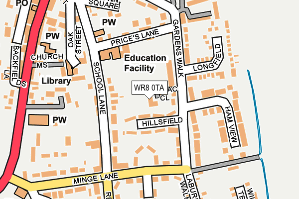
WR8 0TA lies on Lilac Close in Upton Upon Severn, Worcester. WR8 0TA is located in the Upton & Ripple electoral ward, within the local authority district of Malvern Hills and the English Parliamentary constituency of West Worcestershire. The Sub Integrated Care Board (ICB) Location is NHS Herefordshire and Worcestershire ICB - 18C and the police force is West Mercia. This postcode has been in use since December 1997.


GetTheData
Source: OS OpenMap – Local (Ordnance Survey)
Source: OS VectorMap District (Ordnance Survey)
Licence: Open Government Licence (requires attribution)
| Easting | 385373 |
| Northing | 240320 |
| Latitude | 52.061062 |
| Longitude | -2.214762 |
GetTheData
Source: Open Postcode Geo
Licence: Open Government Licence
| Street | Lilac Close |
| Locality | Upton Upon Severn |
| Town/City | Worcester |
| Country | England |
| Postcode District | WR8 |
| ➜ WR8 open data dashboard ➜ See where WR8 is on a map ➜ Where is Upton upon Severn? | |
GetTheData
Source: Land Registry Price Paid Data
Licence: Open Government Licence
Elevation or altitude of WR8 0TA as distance above sea level:
| Metres | Feet | |
|---|---|---|
| Elevation | 10m | 33ft |
Elevation is measured from the approximate centre of the postcode, to the nearest point on an OS contour line from OS Terrain 50, which has contour spacing of ten vertical metres.
➜ How high above sea level am I? Find the elevation of your current position using your device's GPS.
GetTheData
Source: Open Postcode Elevation
Licence: Open Government Licence
| Ward | Upton & Ripple |
| Constituency | West Worcestershire |
GetTheData
Source: ONS Postcode Database
Licence: Open Government Licence
| January 2024 | Other theft | On or near Parking Area | 402m |
| August 2023 | Anti-social behaviour | On or near Parking Area | 402m |
| July 2023 | Criminal damage and arson | On or near Parking Area | 402m |
| ➜ Lilac Close crime map and outcomes | |||
GetTheData
Source: data.police.uk
Licence: Open Government Licence
| Upton Ce Primary School (School Lane) | Upton Upon Severn | 125m |
| Church (Old Street) | Upton Upon Severn | 248m |
| Church (Old Street) | Upton Upon Severn | 307m |
| Thomas Morris House (Queensmead) | Upton Upon Severn | 314m |
| High Street | Upton Upon Severn | 323m |
GetTheData
Source: NaPTAN
Licence: Open Government Licence
| Percentage of properties with Next Generation Access | 100.0% |
| Percentage of properties with Superfast Broadband | 100.0% |
| Percentage of properties with Ultrafast Broadband | 0.0% |
| Percentage of properties with Full Fibre Broadband | 0.0% |
Superfast Broadband is between 30Mbps and 300Mbps
Ultrafast Broadband is > 300Mbps
| Percentage of properties unable to receive 2Mbps | 0.0% |
| Percentage of properties unable to receive 5Mbps | 0.0% |
| Percentage of properties unable to receive 10Mbps | 0.0% |
| Percentage of properties unable to receive 30Mbps | 0.0% |
GetTheData
Source: Ofcom
Licence: Ofcom Terms of Use (requires attribution)
GetTheData
Source: ONS Postcode Database
Licence: Open Government Licence

➜ Get more ratings from the Food Standards Agency
GetTheData
Source: Food Standards Agency
Licence: FSA terms & conditions
| Last Collection | |||
|---|---|---|---|
| Location | Mon-Fri | Sat | Distance |
| Rectory Road | 16:45 | 10:30 | 184m |
| Gardens Walk | 16:30 | 08:00 | 194m |
| Upton-on-severn P.o. | 17:30 | 11:15 | 289m |
GetTheData
Source: Dracos
Licence: Creative Commons Attribution-ShareAlike
| Facility | Distance |
|---|---|
| Upton-upon-severn C.e. Primary School School Lane, Upton-upon-severn, Worcester Grass Pitches | 133m |
| Upton-upon-severn Rfc Old Street, Upton Upon Severn Grass Pitches | 407m |
| The Upton Hill Community Centre Milestone Road, Upton-upon-severn, Worcester Sports Hall, Grass Pitches | 1.5km |
GetTheData
Source: Active Places
Licence: Open Government Licence
| School | Phase of Education | Distance |
|---|---|---|
| Upton-Upon-Severn CofE Primary and Pre School School Lane, Upton-upon-Severn, Worcester, WR8 0LD | Primary | 133m |
| Hanley Castle High School Church End, Hanley Castle, Worcester, WR8 0BL | Secondary | 2.2km |
| Bredon School Pull Court, Bushley, Tewkesbury, Gloucestershire, Gl20 5JG | Not applicable | 4.3km |
GetTheData
Source: Edubase
Licence: Open Government Licence
The below table lists the International Territorial Level (ITL) codes (formerly Nomenclature of Territorial Units for Statistics (NUTS) codes) and Local Administrative Units (LAU) codes for WR8 0TA:
| ITL 1 Code | Name |
|---|---|
| TLG | West Midlands (England) |
| ITL 2 Code | Name |
| TLG1 | Herefordshire, Worcestershire and Warwickshire |
| ITL 3 Code | Name |
| TLG12 | Worcestershire CC |
| LAU 1 Code | Name |
| E07000235 | Malvern Hills |
GetTheData
Source: ONS Postcode Directory
Licence: Open Government Licence
The below table lists the Census Output Area (OA), Lower Layer Super Output Area (LSOA), and Middle Layer Super Output Area (MSOA) for WR8 0TA:
| Code | Name | |
|---|---|---|
| OA | E00164334 | |
| LSOA | E01032215 | Malvern Hills 011C |
| MSOA | E02006720 | Malvern Hills 011 |
GetTheData
Source: ONS Postcode Directory
Licence: Open Government Licence
| WR8 0LH | Hillsfield | 40m |
| WR8 0LD | School Lane | 76m |
| WR8 0LJ | Gardens Walk | 82m |
| WR8 0LL | Gardens Walk | 87m |
| WR8 0LT | Gardens Close | 98m |
| WR8 0LN | Gardens Walk | 119m |
| WR8 0LE | School Lane | 125m |
| WR8 0LQ | School Lane | 136m |
| WR8 0LY | Prices Lane | 140m |
| WR8 0NR | Longfield | 149m |
GetTheData
Source: Open Postcode Geo; Land Registry Price Paid Data
Licence: Open Government Licence