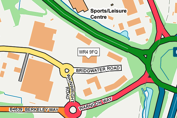
WR4 9FQ is located in the Warndon Parish North electoral ward, within the local authority district of Worcester and the English Parliamentary constituency of Worcester. The Sub Integrated Care Board (ICB) Location is NHS Herefordshire and Worcestershire ICB - 18C and the police force is West Mercia. This postcode has been in use since June 2014.


GetTheData
Source: OS OpenMap – Local (Ordnance Survey)
Source: OS VectorMap District (Ordnance Survey)
Licence: Open Government Licence (requires attribution)
| Easting | 389065 |
| Northing | 257221 |
| Latitude | 52.213108 |
| Longitude | -2.161455 |
GetTheData
Source: Open Postcode Geo
Licence: Open Government Licence
| Country | England |
| Postcode District | WR4 |
➜ See where WR4 is on a map ➜ Where is Worcester? | |
GetTheData
Source: Land Registry Price Paid Data
Licence: Open Government Licence
Elevation or altitude of WR4 9FQ as distance above sea level:
| Metres | Feet | |
|---|---|---|
| Elevation | 40m | 131ft |
Elevation is measured from the approximate centre of the postcode, to the nearest point on an OS contour line from OS Terrain 50, which has contour spacing of ten vertical metres.
➜ How high above sea level am I? Find the elevation of your current position using your device's GPS.
GetTheData
Source: Open Postcode Elevation
Licence: Open Government Licence
| Ward | Warndon Parish North |
| Constituency | Worcester |
GetTheData
Source: ONS Postcode Database
Licence: Open Government Licence
| Three Pears (Wainwright Road) | Warndon Villages | 174m |
| Three Pears (Wainwright Road) | Warndon Villages | 177m |
| Shire Park Rdc (Wainwright Road) | Warndon Villages | 380m |
| Sixways Park And Ride Site (Warriors Way) | Warndon Villages | 406m |
| Shire Park Rdc (Wainwright Road) | Warndon Villages | 484m |
| Worcester Shrub Hill Station | 3.9km |
| Worcester Foregate Street Station | 4.6km |
GetTheData
Source: NaPTAN
Licence: Open Government Licence
GetTheData
Source: ONS Postcode Database
Licence: Open Government Licence


➜ Get more ratings from the Food Standards Agency
GetTheData
Source: Food Standards Agency
Licence: FSA terms & conditions
| Last Collection | |||
|---|---|---|---|
| Location | Mon-Fri | Sat | Distance |
| Hastings Drive | 16:45 | 11:30 | 1,113m |
| Worcester Sorting Office | 19:30 | 15:00 | 1,321m |
| Tibberton Vicarage | 16:30 | 09:30 | 1,388m |
GetTheData
Source: Dracos
Licence: Creative Commons Attribution-ShareAlike
| Risk of WR4 9FQ flooding from rivers and sea | Medium |
| ➜ WR4 9FQ flood map | |
GetTheData
Source: Open Flood Risk by Postcode
Licence: Open Government Licence
The below table lists the International Territorial Level (ITL) codes (formerly Nomenclature of Territorial Units for Statistics (NUTS) codes) and Local Administrative Units (LAU) codes for WR4 9FQ:
| ITL 1 Code | Name |
|---|---|
| TLG | West Midlands (England) |
| ITL 2 Code | Name |
| TLG1 | Herefordshire, Worcestershire and Warwickshire |
| ITL 3 Code | Name |
| TLG12 | Worcestershire CC |
| LAU 1 Code | Name |
| E07000237 | Worcester |
GetTheData
Source: ONS Postcode Directory
Licence: Open Government Licence
The below table lists the Census Output Area (OA), Lower Layer Super Output Area (LSOA), and Middle Layer Super Output Area (MSOA) for WR4 9FQ:
| Code | Name | |
|---|---|---|
| OA | E00164920 | |
| LSOA | E01032335 | Worcester 003C |
| MSOA | E02006736 | Worcester 003 |
GetTheData
Source: ONS Postcode Directory
Licence: Open Government Licence
| WR4 0SL | St Nicholas Lane | 427m |
| WR4 0TB | Newark Green | 482m |
| WR4 0TE | Falmouth | 548m |
| WR4 0TA | Stafford Avenue | 567m |
| WR4 0RU | Tutbury Row | 598m |
| WR4 0TD | Hardknott Row | 609m |
| WR4 0LJ | Deal Crescent | 615m |
| WR4 0SN | Rockingham Lane | 639m |
| WR4 0LD | Stokesay Lane | 664m |
| WR4 0SH | Ripley Gardens | 667m |
GetTheData
Source: Open Postcode Geo; Land Registry Price Paid Data
Licence: Open Government Licence