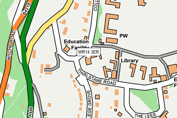
WR14 3ER is located in the Great Malvern electoral ward, within the local authority district of Malvern Hills and the English Parliamentary constituency of West Worcestershire. The Sub Integrated Care Board (ICB) Location is NHS Herefordshire and Worcestershire ICB - 18C and the police force is West Mercia. This postcode has been in use since May 2004.


GetTheData
Source: OS OpenMap – Local (Ordnance Survey)
Source: OS VectorMap District (Ordnance Survey)
Licence: Open Government Licence (requires attribution)
| Easting | 377696 |
| Northing | 245022 |
| Latitude | 52.103077 |
| Longitude | -2.327045 |
GetTheData
Source: Open Postcode Geo
Licence: Open Government Licence
| Country | England |
| Postcode District | WR14 |
| ➜ WR14 open data dashboard ➜ See where WR14 is on a map ➜ Where is Great Malvern? | |
GetTheData
Source: Land Registry Price Paid Data
Licence: Open Government Licence
Elevation or altitude of WR14 3ER as distance above sea level:
| Metres | Feet | |
|---|---|---|
| Elevation | 120m | 394ft |
Elevation is measured from the approximate centre of the postcode, to the nearest point on an OS contour line from OS Terrain 50, which has contour spacing of ten vertical metres.
➜ How high above sea level am I? Find the elevation of your current position using your device's GPS.
GetTheData
Source: Open Postcode Elevation
Licence: Open Government Licence
| Ward | Great Malvern |
| Constituency | West Worcestershire |
GetTheData
Source: ONS Postcode Database
Licence: Open Government Licence
| January 2024 | Vehicle crime | On or near Abbey Road | 408m |
| December 2023 | Criminal damage and arson | On or near Abbey Road | 408m |
| June 2022 | Vehicle crime | On or near Abbey Road | 408m |
| ➜ Get more crime data in our Crime section | |||
GetTheData
Source: data.police.uk
Licence: Open Government Licence
| Abbey Road (Worcester Road) | Great Malvern | 201m |
| Emmanuel Church (Wells Road) | Great Malvern | 269m |
| Emmanuel Church (Wells Road) | Great Malvern | 349m |
| Crellin House (Priory Road-) | Great Malvern | 428m |
| Thirlstane Road (St Andrew's Road) | Barnard's Green | 546m |
| Great Malvern Station | 0.9km |
| Malvern Link Station | 2.5km |
| Colwall Station | 3.3km |
GetTheData
Source: NaPTAN
Licence: Open Government Licence
GetTheData
Source: ONS Postcode Database
Licence: Open Government Licence


➜ Get more ratings from the Food Standards Agency
GetTheData
Source: Food Standards Agency
Licence: FSA terms & conditions
| Last Collection | |||
|---|---|---|---|
| Location | Mon-Fri | Sat | Distance |
| College Grove | 17:30 | 11:30 | 42m |
| Thirlstane Road | 17:30 | 11:30 | 251m |
| Abbey Road | 17:30 | 11:30 | 333m |
GetTheData
Source: Dracos
Licence: Creative Commons Attribution-ShareAlike
| Facility | Distance |
|---|---|
| Malvern College Sports Complex Off Thirlstane Road, Malvern Health and Fitness Gym, Swimming Pool, Sports Hall, Artificial Grass Pitch, Grass Pitches, Squash Courts, Studio | 287m |
| Revolution Fitness (Closed) Wells Road, Malvern Health and Fitness Gym, Studio | 364m |
| Malvern Splash Leisure Complex Priory Road, Malvern Swimming Pool, Health and Fitness Gym, Studio | 811m |
GetTheData
Source: Active Places
Licence: Open Government Licence
| School | Phase of Education | Distance |
|---|---|---|
| Malvern College College Road, Malvern, Malvern, WR14 3DF | Not applicable | 139m |
| Malvern Parish CofE Primary School Manby Road, Malvern, WR14 3BB | Primary | 831m |
| Malvern St James 15 Avenue Road, Malvern, WR14 3BA | Not applicable | 1.1km |
GetTheData
Source: Edubase
Licence: Open Government Licence
The below table lists the International Territorial Level (ITL) codes (formerly Nomenclature of Territorial Units for Statistics (NUTS) codes) and Local Administrative Units (LAU) codes for WR14 3ER:
| ITL 1 Code | Name |
|---|---|
| TLG | West Midlands (England) |
| ITL 2 Code | Name |
| TLG1 | Herefordshire, Worcestershire and Warwickshire |
| ITL 3 Code | Name |
| TLG12 | Worcestershire CC |
| LAU 1 Code | Name |
| E07000235 | Malvern Hills |
GetTheData
Source: ONS Postcode Directory
Licence: Open Government Licence
The below table lists the Census Output Area (OA), Lower Layer Super Output Area (LSOA), and Middle Layer Super Output Area (MSOA) for WR14 3ER:
| Code | Name | |
|---|---|---|
| OA | E00172253 | |
| LSOA | E01032209 | Malvern Hills 010B |
| MSOA | E02006719 | Malvern Hills 010 |
GetTheData
Source: ONS Postcode Directory
Licence: Open Government Licence
| WR14 3HS | Thirlstane Road | 114m |
| WR14 3HW | College Road | 124m |
| WR14 3HL | Abbey Road | 185m |
| WR14 3HP | College Grove | 185m |
| WR14 3HR | Firs Close | 230m |
| WR14 4NZ | Wells Road | 237m |
| WR14 3HT | The Lees | 285m |
| WR14 3HH | Abbey Road | 333m |
| WR14 3DD | College Road | 348m |
| WR14 4RJ | Wells Road | 387m |
GetTheData
Source: Open Postcode Geo; Land Registry Price Paid Data
Licence: Open Government Licence