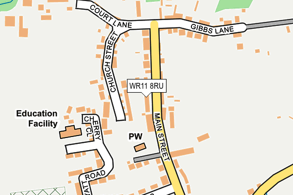
WR11 8RU lies on Avon Court in Offenham, Evesham. WR11 8RU is located in the Bretforton & Offenham electoral ward, within the local authority district of Wychavon and the English Parliamentary constituency of Mid Worcestershire. The Sub Integrated Care Board (ICB) Location is NHS Herefordshire and Worcestershire ICB - 18C and the police force is West Mercia. This postcode has been in use since December 2001.


GetTheData
Source: OS OpenMap – Local (Ordnance Survey)
Source: OS VectorMap District (Ordnance Survey)
Licence: Open Government Licence (requires attribution)
| Easting | 405325 |
| Northing | 246324 |
| Latitude | 52.115213 |
| Longitude | -1.923650 |
GetTheData
Source: Open Postcode Geo
Licence: Open Government Licence
| Street | Avon Court |
| Locality | Offenham |
| Town/City | Evesham |
| Country | England |
| Postcode District | WR11 |
| ➜ WR11 open data dashboard ➜ See where WR11 is on a map ➜ Where is Offenham? | |
GetTheData
Source: Land Registry Price Paid Data
Licence: Open Government Licence
Elevation or altitude of WR11 8RU as distance above sea level:
| Metres | Feet | |
|---|---|---|
| Elevation | 30m | 98ft |
Elevation is measured from the approximate centre of the postcode, to the nearest point on an OS contour line from OS Terrain 50, which has contour spacing of ten vertical metres.
➜ How high above sea level am I? Find the elevation of your current position using your device's GPS.
GetTheData
Source: Open Postcode Elevation
Licence: Open Government Licence
| Ward | Bretforton & Offenham |
| Constituency | Mid Worcestershire |
GetTheData
Source: ONS Postcode Database
Licence: Open Government Licence
| June 2022 | Violence and sexual offences | On or near St Milburgh Close | 244m |
| June 2022 | Violence and sexual offences | On or near Ferry Lane | 397m |
| May 2022 | Other crime | On or near St Milburgh Close | 244m |
| ➜ Get more crime data in our Crime section | |||
GetTheData
Source: data.police.uk
Licence: Open Government Licence
| The Maypole (Main Street) | Offenham | 138m |
| Post Office (Main Street) | Offenham | 408m |
| Post Office (Main Street) | Offenham | 427m |
| Leasowes Road (Main Street) | Offenham | 537m |
| Leasowes Road (Main Street) | Offenham | 542m |
| Evesham Station | 2.5km |
GetTheData
Source: NaPTAN
Licence: Open Government Licence
| Percentage of properties with Next Generation Access | 100.0% |
| Percentage of properties with Superfast Broadband | 100.0% |
| Percentage of properties with Ultrafast Broadband | 0.0% |
| Percentage of properties with Full Fibre Broadband | 0.0% |
Superfast Broadband is between 30Mbps and 300Mbps
Ultrafast Broadband is > 300Mbps
| Percentage of properties unable to receive 2Mbps | 0.0% |
| Percentage of properties unable to receive 5Mbps | 0.0% |
| Percentage of properties unable to receive 10Mbps | 0.0% |
| Percentage of properties unable to receive 30Mbps | 0.0% |
GetTheData
Source: Ofcom
Licence: Ofcom Terms of Use (requires attribution)
GetTheData
Source: ONS Postcode Database
Licence: Open Government Licence


➜ Get more ratings from the Food Standards Agency
GetTheData
Source: Food Standards Agency
Licence: FSA terms & conditions
| Last Collection | |||
|---|---|---|---|
| Location | Mon-Fri | Sat | Distance |
| Offenham Village | 16:00 | 09:15 | 37m |
| Offenham P.o. | 16:00 | 10:30 | 412m |
| Three Cocks Lane | 16:00 | 09:45 | 502m |
GetTheData
Source: Dracos
Licence: Creative Commons Attribution-ShareAlike
| Facility | Distance |
|---|---|
| Offenham Recreation Ground Three Cocks Lane, Offenham Grass Pitches | 290m |
| Harvington Golf Centre Anchor Lane, Harvington, Evesham Golf | 1.6km |
| Green Hill School (Closed) Greenhill, Evesham Grass Pitches | 1.9km |
GetTheData
Source: Active Places
Licence: Open Government Licence
| School | Phase of Education | Distance |
|---|---|---|
| Offenham Church of England First School Myatt Road, Offenham, Evesham, WR11 8SD | Primary | 172m |
| Blackminster Middle School Station Road, South Littleton, Evesham, WR11 8TG | Middle deemed secondary | 2.2km |
| Prince Henry's High School Victoria Avenue, Evesham, WR11 4QH | Secondary | 2.2km |
GetTheData
Source: Edubase
Licence: Open Government Licence
The below table lists the International Territorial Level (ITL) codes (formerly Nomenclature of Territorial Units for Statistics (NUTS) codes) and Local Administrative Units (LAU) codes for WR11 8RU:
| ITL 1 Code | Name |
|---|---|
| TLG | West Midlands (England) |
| ITL 2 Code | Name |
| TLG1 | Herefordshire, Worcestershire and Warwickshire |
| ITL 3 Code | Name |
| TLG12 | Worcestershire CC |
| LAU 1 Code | Name |
| E07000238 | Wychavon |
GetTheData
Source: ONS Postcode Directory
Licence: Open Government Licence
The below table lists the Census Output Area (OA), Lower Layer Super Output Area (LSOA), and Middle Layer Super Output Area (MSOA) for WR11 8RU:
| Code | Name | |
|---|---|---|
| OA | E00164995 | |
| LSOA | E01032349 | Wychavon 013C |
| MSOA | E02006760 | Wychavon 013 |
GetTheData
Source: ONS Postcode Directory
Licence: Open Government Licence
| WR11 8QD | Main Street | 72m |
| WR11 8RW | Church Street | 82m |
| WR11 8RX | Main Street | 104m |
| WR11 8SF | Old School Close | 133m |
| WR11 8SQ | Cherry Close | 134m |
| WR11 8RH | Norval Crescent | 185m |
| WR11 8RR | Gibbs Lane | 190m |
| WR11 8RJ | St Milburgh Close | 229m |
| WR11 8RP | Court Lane | 239m |
| WR11 8SD | Myatt Road | 254m |
GetTheData
Source: Open Postcode Geo; Land Registry Price Paid Data
Licence: Open Government Licence