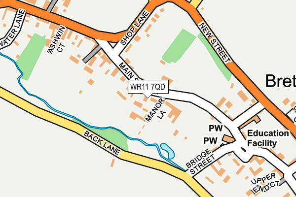
WR11 7QD lies on Squires Court in Bretforton, Evesham. WR11 7QD is located in the Bretforton & Offenham electoral ward, within the local authority district of Wychavon and the English Parliamentary constituency of Mid Worcestershire. The Sub Integrated Care Board (ICB) Location is NHS Herefordshire and Worcestershire ICB - 18C and the police force is West Mercia. This postcode has been in use since December 2001.


GetTheData
Source: OS OpenMap – Local (Ordnance Survey)
Source: OS VectorMap District (Ordnance Survey)
Licence: Open Government Licence (requires attribution)
| Easting | 409140 |
| Northing | 243894 |
| Latitude | 52.093317 |
| Longitude | -1.868002 |
GetTheData
Source: Open Postcode Geo
Licence: Open Government Licence
| Street | Squires Court |
| Locality | Bretforton |
| Town/City | Evesham |
| Country | England |
| Postcode District | WR11 |
| ➜ WR11 open data dashboard ➜ See where WR11 is on a map ➜ Where is Bretforton? | |
GetTheData
Source: Land Registry Price Paid Data
Licence: Open Government Licence
Elevation or altitude of WR11 7QD as distance above sea level:
| Metres | Feet | |
|---|---|---|
| Elevation | 40m | 131ft |
Elevation is measured from the approximate centre of the postcode, to the nearest point on an OS contour line from OS Terrain 50, which has contour spacing of ten vertical metres.
➜ How high above sea level am I? Find the elevation of your current position using your device's GPS.
GetTheData
Source: Open Postcode Elevation
Licence: Open Government Licence
| Ward | Bretforton & Offenham |
| Constituency | Mid Worcestershire |
GetTheData
Source: ONS Postcode Database
Licence: Open Government Licence
| June 2022 | Public order | On or near Manor Lane | 23m |
| June 2022 | Violence and sexual offences | On or near Station Road | 387m |
| June 2022 | Criminal damage and arson | On or near Station Road | 387m |
| ➜ Get more crime data in our Crime section | |||
GetTheData
Source: data.police.uk
Licence: Open Government Licence
| School Lane (New Street) | Bretforton | 255m |
| Victoria Gardens (Main Street) | Bretforton | 257m |
| School Lane (New Street) | Bretforton | 267m |
| Shelter (Coldicotts Lane) | Bretforton | 389m |
| Coldicotts Lane | Bretforton | 405m |
| Honeybourne Station | 2.5km |
GetTheData
Source: NaPTAN
Licence: Open Government Licence
| Percentage of properties with Next Generation Access | 100.0% |
| Percentage of properties with Superfast Broadband | 100.0% |
| Percentage of properties with Ultrafast Broadband | 0.0% |
| Percentage of properties with Full Fibre Broadband | 0.0% |
Superfast Broadband is between 30Mbps and 300Mbps
Ultrafast Broadband is > 300Mbps
| Percentage of properties unable to receive 2Mbps | 0.0% |
| Percentage of properties unable to receive 5Mbps | 0.0% |
| Percentage of properties unable to receive 10Mbps | 0.0% |
| Percentage of properties unable to receive 30Mbps | 0.0% |
GetTheData
Source: Ofcom
Licence: Ofcom Terms of Use (requires attribution)
GetTheData
Source: ONS Postcode Database
Licence: Open Government Licence

➜ Get more ratings from the Food Standards Agency
GetTheData
Source: Food Standards Agency
Licence: FSA terms & conditions
| Last Collection | |||
|---|---|---|---|
| Location | Mon-Fri | Sat | Distance |
| Lower End | 17:00 | 10:15 | 150m |
| Bretforton P.o. | 17:00 | 10:15 | 282m |
| Ivy Lane | 16:45 | 10:15 | 506m |
GetTheData
Source: Dracos
Licence: Creative Commons Attribution-ShareAlike
| Facility | Distance |
|---|---|
| Bretforton Village School New Street, Bretforton, Evesham Grass Pitches | 197m |
| Bretforton Recreation Ground Station Road, Bretforton, Evesham Grass Pitches | 444m |
| Ballards Park Brewers Lane, Badsey, Evesham Grass Pitches | 1.7km |
GetTheData
Source: Active Places
Licence: Open Government Licence
| School | Phase of Education | Distance |
|---|---|---|
| Bretforton Village School New Street, Bretforton, Evesham, WR11 7JS | Primary | 197m |
| Badsey First School School Lane, Badsey, Evesham, WR11 7ES | Primary | 2.2km |
| Honeybourne Primary Academy School Street, Honeybourne, Evesham, WR11 7PJ | Primary | 2.3km |
GetTheData
Source: Edubase
Licence: Open Government Licence
The below table lists the International Territorial Level (ITL) codes (formerly Nomenclature of Territorial Units for Statistics (NUTS) codes) and Local Administrative Units (LAU) codes for WR11 7QD:
| ITL 1 Code | Name |
|---|---|
| TLG | West Midlands (England) |
| ITL 2 Code | Name |
| TLG1 | Herefordshire, Worcestershire and Warwickshire |
| ITL 3 Code | Name |
| TLG12 | Worcestershire CC |
| LAU 1 Code | Name |
| E07000238 | Wychavon |
GetTheData
Source: ONS Postcode Directory
Licence: Open Government Licence
The below table lists the Census Output Area (OA), Lower Layer Super Output Area (LSOA), and Middle Layer Super Output Area (MSOA) for WR11 7QD:
| Code | Name | |
|---|---|---|
| OA | E00164991 | |
| LSOA | E01032350 | Wychavon 013D |
| MSOA | E02006760 | Wychavon 013 |
GetTheData
Source: ONS Postcode Directory
Licence: Open Government Licence
| WR11 7JR | Manor Lane | 44m |
| WR11 7JW | Whitford Close | 137m |
| WR11 7JF | Shop Lane | 142m |
| WR11 7JH | Main Street | 154m |
| WR11 7JD | Bridge Street | 185m |
| WR11 7JG | School Lane | 193m |
| WR11 7JE | The Cross | 217m |
| WR11 7HL | Ashwin Court | 221m |
| WR11 7JA | Back Lane | 254m |
| WR11 7FR | Victoria Gardens | 272m |
GetTheData
Source: Open Postcode Geo; Land Registry Price Paid Data
Licence: Open Government Licence