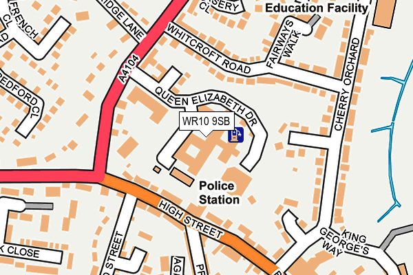
WR10 9SB is located in the Pershore electoral ward, within the local authority district of Wychavon and the English Parliamentary constituency of West Worcestershire. The Sub Integrated Care Board (ICB) Location is NHS Herefordshire and Worcestershire ICB - 18C and the police force is West Mercia. This postcode has been in use since February 2005.


GetTheData
Source: OS OpenMap – Local (Ordnance Survey)
Source: OS VectorMap District (Ordnance Survey)
Licence: Open Government Licence (requires attribution)
| Easting | 394737 |
| Northing | 246245 |
| Latitude | 52.114513 |
| Longitude | -2.078265 |
GetTheData
Source: Open Postcode Geo
Licence: Open Government Licence
| Country | England |
| Postcode District | WR10 |
| ➜ WR10 open data dashboard ➜ See where WR10 is on a map ➜ Where is Pershore? | |
GetTheData
Source: Land Registry Price Paid Data
Licence: Open Government Licence
Elevation or altitude of WR10 9SB as distance above sea level:
| Metres | Feet | |
|---|---|---|
| Elevation | 30m | 98ft |
Elevation is measured from the approximate centre of the postcode, to the nearest point on an OS contour line from OS Terrain 50, which has contour spacing of ten vertical metres.
➜ How high above sea level am I? Find the elevation of your current position using your device's GPS.
GetTheData
Source: Open Postcode Elevation
Licence: Open Government Licence
| Ward | Pershore |
| Constituency | West Worcestershire |
GetTheData
Source: ONS Postcode Database
Licence: Open Government Licence
| January 2024 | Criminal damage and arson | On or near Pippin Close | 377m |
| January 2024 | Burglary | On or near Petrol Station | 424m |
| October 2023 | Violence and sexual offences | On or near Petrol Station | 424m |
| ➜ Get more crime data in our Crime section | |||
GetTheData
Source: data.police.uk
Licence: Open Government Licence
| Head Street | Pershore | 97m |
| Head Street (High Street) | Pershore | 113m |
| Whitcroft Road (Station Road) | Pershore | 174m |
| Redland House (Cherry Orchard) | Pershore | 188m |
| Whitcroft Road (Station Road) | Pershore | 203m |
| Pershore Station | 1.8km |
GetTheData
Source: NaPTAN
Licence: Open Government Licence
GetTheData
Source: ONS Postcode Database
Licence: Open Government Licence


➜ Get more ratings from the Food Standards Agency
GetTheData
Source: Food Standards Agency
Licence: FSA terms & conditions
| Last Collection | |||
|---|---|---|---|
| Location | Mon-Fri | Sat | Distance |
| High Street | 17:30 | 11:00 | 98m |
| Whitcroft Road | 17:30 | 11:00 | 142m |
| Newlands | 17:30 | 11:00 | 370m |
GetTheData
Source: Dracos
Licence: Creative Commons Attribution-ShareAlike
| Facility | Distance |
|---|---|
| Recruit 12 Community Stadium King Georges Way, Pershore Grass Pitches | 372m |
| Pershore Leisure Centre King Georges Way, Pershore Sports Hall, Swimming Pool, Health and Fitness Gym, Studio | 447m |
| Abbey Park Middle School Abbey Road, Pershore Grass Pitches | 530m |
GetTheData
Source: Active Places
Licence: Open Government Licence
| School | Phase of Education | Distance |
|---|---|---|
| Holy Redeemer Catholic Primary School Priest Lane, Pershore, WR10 1EB | Primary | 286m |
| Orchard Primary School Cherry Orchard, Pershore, WR10 1ET | Primary | 324m |
| Abbey Park Middle School Abbey Road, Pershore, WR10 1DF | Middle deemed primary | 504m |
GetTheData
Source: Edubase
Licence: Open Government Licence
The below table lists the International Territorial Level (ITL) codes (formerly Nomenclature of Territorial Units for Statistics (NUTS) codes) and Local Administrative Units (LAU) codes for WR10 9SB:
| ITL 1 Code | Name |
|---|---|
| TLG | West Midlands (England) |
| ITL 2 Code | Name |
| TLG1 | Herefordshire, Worcestershire and Warwickshire |
| ITL 3 Code | Name |
| TLG12 | Worcestershire CC |
| LAU 1 Code | Name |
| E07000238 | Wychavon |
GetTheData
Source: ONS Postcode Directory
Licence: Open Government Licence
The below table lists the Census Output Area (OA), Lower Layer Super Output Area (LSOA), and Middle Layer Super Output Area (MSOA) for WR10 9SB:
| Code | Name | |
|---|---|---|
| OA | E00165294 | |
| LSOA | E01032409 | Wychavon 012E |
| MSOA | E02006759 | Wychavon 012 |
GetTheData
Source: ONS Postcode Directory
Licence: Open Government Licence
| WR10 1EQ | High Street | 98m |
| WR10 1EE | High Street | 114m |
| WR10 1HB | Bagshaw Court | 141m |
| WR10 1NG | Station Road | 142m |
| WR10 1EN | Whitcroft Road | 144m |
| WR10 1EJ | Redlands | 146m |
| WR10 1EA | High Street | 157m |
| WR10 1EW | Whitcroft Road | 160m |
| WR10 1EL | Cherry Orchard | 161m |
| WR10 1DJ | Priest Lane | 166m |
GetTheData
Source: Open Postcode Geo; Land Registry Price Paid Data
Licence: Open Government Licence