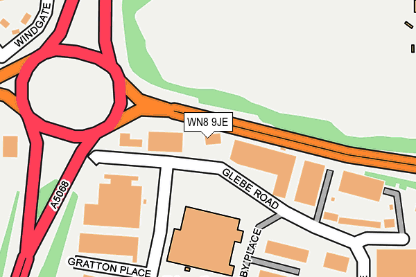
WN8 9JE is located in the Skelmersdale South electoral ward, within the local authority district of West Lancashire and the English Parliamentary constituency of West Lancashire. The Sub Integrated Care Board (ICB) Location is NHS Lancashire and South Cumbria ICB - 02G and the police force is Lancashire. This postcode has been in use since August 1993.


GetTheData
Source: OS OpenMap – Local (Ordnance Survey)
Source: OS VectorMap District (Ordnance Survey)
Licence: Open Government Licence (requires attribution)
| Easting | 348216 |
| Northing | 405766 |
| Latitude | 53.545964 |
| Longitude | -2.782973 |
GetTheData
Source: Open Postcode Geo
Licence: Open Government Licence
| Country | England |
| Postcode District | WN8 |
| ➜ WN8 open data dashboard ➜ See where WN8 is on a map ➜ Where is Skelmersdale? | |
GetTheData
Source: Land Registry Price Paid Data
Licence: Open Government Licence
Elevation or altitude of WN8 9JE as distance above sea level:
| Metres | Feet | |
|---|---|---|
| Elevation | 60m | 197ft |
Elevation is measured from the approximate centre of the postcode, to the nearest point on an OS contour line from OS Terrain 50, which has contour spacing of ten vertical metres.
➜ How high above sea level am I? Find the elevation of your current position using your device's GPS.
GetTheData
Source: Open Postcode Elevation
Licence: Open Government Licence
| Ward | Skelmersdale South |
| Constituency | West Lancashire |
GetTheData
Source: ONS Postcode Database
Licence: Open Government Licence
| June 2022 | Shoplifting | On or near Petrol Station | 1m |
| June 2022 | Other theft | On or near Petrol Station | 1m |
| June 2022 | Other theft | On or near Petrol Station | 1m |
| ➜ Get more crime data in our Crime section | |||
GetTheData
Source: data.police.uk
Licence: Open Government Licence
| Grimshaw Road | Gillibrands | 187m |
| Railway Road | Pennylands | 419m |
| Railway Road | Pennylands | 426m |
| Glebe Road (Gillibrands Road) | Gillibrands | 448m |
| Glebe Road (Gillibrands Road) | Gillibrands | 456m |
| Rainford Station | 3.2km |
| Upholland Station | 3.4km |
| Parbold Station | 5km |
GetTheData
Source: NaPTAN
Licence: Open Government Licence
GetTheData
Source: ONS Postcode Database
Licence: Open Government Licence


➜ Get more ratings from the Food Standards Agency
GetTheData
Source: Food Standards Agency
Licence: FSA terms & conditions
| Last Collection | |||
|---|---|---|---|
| Location | Mon-Fri | Sat | Distance |
| Skelmersdale Delivery Office | 19:00 | 12:00 | 216m |
| Gillibrands Road Business Box | 440m | ||
| Winsters P O | 18:30 | 11:15 | 798m |
GetTheData
Source: Dracos
Licence: Creative Commons Attribution-ShareAlike
| Facility | Distance |
|---|---|
| Activ 8 At Glenburn Sports College (Closed) Yewdale, Southway, Skelmersdale Health and Fitness Gym, Artificial Grass Pitch, Athletics, Grass Pitches, Sports Hall, Studio | 385m |
| Skelmersdale College Sports Complex (Closed) Yewdale, Skelmersdale Sports Hall, Swimming Pool, Health and Fitness Gym, Studio | 660m |
| Nye Bevan Pool Southway, Skelmersdale Swimming Pool, Health and Fitness Gym | 711m |
GetTheData
Source: Active Places
Licence: Open Government Licence
| School | Phase of Education | Distance |
|---|---|---|
| St Edmund's Catholic Primary School Windrows, New Church Farm, Skelmersdale, WN8 8NP | Primary | 643m |
| Delph Side Community Primary School Eskdale, Tanhouse, Skelmersdale, WN8 6ED | Primary | 823m |
| Trinity Church of England/Methodist School Kiln Lane, Skelmersdale, WN8 8PW | Primary | 1km |
GetTheData
Source: Edubase
Licence: Open Government Licence
The below table lists the International Territorial Level (ITL) codes (formerly Nomenclature of Territorial Units for Statistics (NUTS) codes) and Local Administrative Units (LAU) codes for WN8 9JE:
| ITL 1 Code | Name |
|---|---|
| TLD | North West (England) |
| ITL 2 Code | Name |
| TLD4 | Lancashire |
| ITL 3 Code | Name |
| TLD47 | Chorley and West Lancashire |
| LAU 1 Code | Name |
| E07000127 | West Lancashire |
GetTheData
Source: ONS Postcode Directory
Licence: Open Government Licence
The below table lists the Census Output Area (OA), Lower Layer Super Output Area (LSOA), and Middle Layer Super Output Area (MSOA) for WN8 9JE:
| Code | Name | |
|---|---|---|
| OA | E00129508 | |
| LSOA | E01025521 | West Lancashire 010F |
| MSOA | E02005313 | West Lancashire 010 |
GetTheData
Source: ONS Postcode Directory
Licence: Open Government Licence
| WN8 9JP | Glebe Road | 161m |
| WN8 9UL | Greetby Place | 215m |
| WN8 9UE | Gratton Place | 264m |
| WN8 8NZ | Windgate | 317m |
| WN8 9UB | Garnett Place | 318m |
| WN8 8NN | Windrows | 403m |
| WN8 6EP | Yewdale | 411m |
| WN8 8NB | Wigan Road | 424m |
| WN8 9SA | Greenhey Place | 427m |
| WN8 8NL | Windrows | 443m |
GetTheData
Source: Open Postcode Geo; Land Registry Price Paid Data
Licence: Open Government Licence