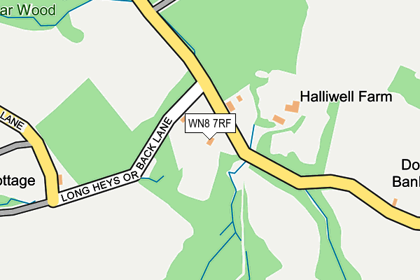
WN8 7RF is located in the Rural North East electoral ward, within the local authority district of West Lancashire and the English Parliamentary constituency of West Lancashire. The Sub Integrated Care Board (ICB) Location is NHS Lancashire and South Cumbria ICB - 02G and the police force is Lancashire. This postcode has been in use since January 1980.


GetTheData
Source: OS OpenMap – Local (Ordnance Survey)
Source: OS VectorMap District (Ordnance Survey)
Licence: Open Government Licence (requires attribution)
| Easting | 351706 |
| Northing | 408572 |
| Latitude | 53.571533 |
| Longitude | -2.730743 |
GetTheData
Source: Open Postcode Geo
Licence: Open Government Licence
| Country | England |
| Postcode District | WN8 |
| ➜ WN8 open data dashboard ➜ See where WN8 is on a map | |
GetTheData
Source: Land Registry Price Paid Data
Licence: Open Government Licence
Elevation or altitude of WN8 7RF as distance above sea level:
| Metres | Feet | |
|---|---|---|
| Elevation | 40m | 131ft |
Elevation is measured from the approximate centre of the postcode, to the nearest point on an OS contour line from OS Terrain 50, which has contour spacing of ten vertical metres.
➜ How high above sea level am I? Find the elevation of your current position using your device's GPS.
GetTheData
Source: Open Postcode Elevation
Licence: Open Government Licence
| Ward | Rural North East |
| Constituency | West Lancashire |
GetTheData
Source: ONS Postcode Database
Licence: Open Government Licence
| November 2023 | Anti-social behaviour | On or near Long Heys Or Back Lane | 87m |
| March 2022 | Violence and sexual offences | On or near Long Heys Or Back Lane | 87m |
| November 2021 | Violence and sexual offences | On or near Long Heys Or Back Lane | 87m |
| ➜ Get more crime data in our Crime section | |||
GetTheData
Source: data.police.uk
Licence: Open Government Licence
| Bank Brow (Appley Lane South) | Holland Lees | 335m |
| Appley Lane South | Holland Lees | 501m |
| Appley Lane Stores (Appley Lane South) | Appley Bridge | 599m |
| Appley Lane Stores (Appley Lane South) | Appley Bridge | 599m |
| Heys Street (Appley Lane South) | Appley Bridge | 726m |
| Appley Bridge Station | 1.1km |
| Gathurst Station | 2.8km |
| Parbold Station | 3.4km |
GetTheData
Source: NaPTAN
Licence: Open Government Licence
GetTheData
Source: ONS Postcode Database
Licence: Open Government Licence


➜ Get more ratings from the Food Standards Agency
GetTheData
Source: Food Standards Agency
Licence: FSA terms & conditions
| Last Collection | |||
|---|---|---|---|
| Location | Mon-Fri | Sat | Distance |
| 12 Roby Mill | 18:30 | 11:00 | 1,265m |
| Ashurst Beacon | 16:40 | 11:00 | 1,801m |
| Dalton Summit | 16:45 | 11:00 | 2,178m |
GetTheData
Source: Dracos
Licence: Creative Commons Attribution-ShareAlike
| Facility | Distance |
|---|---|
| Appley Bridge Fc (The Bridge) Appley Lane South, Appley Bridge Grass Pitches | 729m |
| Dalton Cricket Club Beacon Lane, Dalton Grass Pitches | 1.8km |
| Shevington Vale Primary School Miles Lane, Shevington, Wigan Grass Pitches | 2km |
GetTheData
Source: Active Places
Licence: Open Government Licence
| School | Phase of Education | Distance |
|---|---|---|
| Upholland Roby Mill CofE Voluntary Aided Primary School School Lane, Roby Mill, Up Holland, Skelmersdale, WN8 0QR | Primary | 1.4km |
| Appley Bridge All Saints Church of England Primary Academy Finch Lane, Appley Bridge, Wigan, WN6 9DT | Primary | 1.6km |
| Fir Tree College The Nook, Appley Bridge, Shevington, Wigan, WN6 9JB | Not applicable | 1.7km |
GetTheData
Source: Edubase
Licence: Open Government Licence
The below table lists the International Territorial Level (ITL) codes (formerly Nomenclature of Territorial Units for Statistics (NUTS) codes) and Local Administrative Units (LAU) codes for WN8 7RF:
| ITL 1 Code | Name |
|---|---|
| TLD | North West (England) |
| ITL 2 Code | Name |
| TLD4 | Lancashire |
| ITL 3 Code | Name |
| TLD47 | Chorley and West Lancashire |
| LAU 1 Code | Name |
| E07000127 | West Lancashire |
GetTheData
Source: ONS Postcode Directory
Licence: Open Government Licence
The below table lists the Census Output Area (OA), Lower Layer Super Output Area (LSOA), and Middle Layer Super Output Area (MSOA) for WN8 7RF:
| Code | Name | |
|---|---|---|
| OA | E00129452 | |
| LSOA | E01025510 | West Lancashire 005A |
| MSOA | E02005308 | West Lancashire 005 |
GetTheData
Source: ONS Postcode Directory
Licence: Open Government Licence
| WN8 0SZ | Lees Lane | 105m |
| WN8 7RE | Lees Lane | 471m |
| WN6 9AR | Appley Lane South | 640m |
| WN8 7RT | Long Heys Lane | 662m |
| WN8 0SY | Bank Brow | 694m |
| WN6 9AS | Heyes Street | 721m |
| WN6 9AT | Speakmans Drive | 721m |
| WN6 9AP | Appley Lane North | 838m |
| WN6 9AW | Canal Bank | 864m |
| WN6 9AN | Appley Lane North | 950m |
GetTheData
Source: Open Postcode Geo; Land Registry Price Paid Data
Licence: Open Government Licence