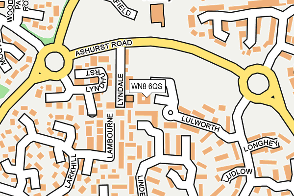
WN8 6QS is located in the Skelmersdale North electoral ward, within the local authority district of West Lancashire and the English Parliamentary constituency of West Lancashire. The Sub Integrated Care Board (ICB) Location is NHS Lancashire and South Cumbria ICB - 02G and the police force is Lancashire. This postcode has been in use since January 1995.


GetTheData
Source: OS OpenMap – Local (Ordnance Survey)
Source: OS VectorMap District (Ordnance Survey)
Licence: Open Government Licence (requires attribution)
| Easting | 348916 |
| Northing | 407677 |
| Latitude | 53.563208 |
| Longitude | -2.772723 |
GetTheData
Source: Open Postcode Geo
Licence: Open Government Licence
| Country | England |
| Postcode District | WN8 |
| ➜ WN8 open data dashboard ➜ See where WN8 is on a map ➜ Where is Skelmersdale? | |
GetTheData
Source: Land Registry Price Paid Data
Licence: Open Government Licence
Elevation or altitude of WN8 6QS as distance above sea level:
| Metres | Feet | |
|---|---|---|
| Elevation | 80m | 262ft |
Elevation is measured from the approximate centre of the postcode, to the nearest point on an OS contour line from OS Terrain 50, which has contour spacing of ten vertical metres.
➜ How high above sea level am I? Find the elevation of your current position using your device's GPS.
GetTheData
Source: Open Postcode Elevation
Licence: Open Government Licence
| Ward | Skelmersdale North |
| Constituency | West Lancashire |
GetTheData
Source: ONS Postcode Database
Licence: Open Government Licence
| January 2024 | Violence and sexual offences | On or near Ludlow | 235m |
| January 2024 | Anti-social behaviour | On or near Ashley Road | 255m |
| January 2024 | Anti-social behaviour | On or near Ashley Road | 255m |
| ➜ Get more crime data in our Crime section | |||
GetTheData
Source: data.police.uk
Licence: Open Government Licence
| Lulworth (Ashley Road) | Ashurst | 209m |
| Lulworth (Ashley Road) | Ashurst | 217m |
| Northfield (Whalleys Road) | Ashurst | 245m |
| Leeswood (Ashley Road) | Ashurst | 267m |
| Lindens | Ashurst | 275m |
| Parbold Station | 3.1km |
| Appley Bridge Station | 3.9km |
| Hoscar Station | 4.4km |
GetTheData
Source: NaPTAN
Licence: Open Government Licence
GetTheData
Source: ONS Postcode Database
Licence: Open Government Licence


➜ Get more ratings from the Food Standards Agency
GetTheData
Source: Food Standards Agency
Licence: FSA terms & conditions
| Last Collection | |||
|---|---|---|---|
| Location | Mon-Fri | Sat | Distance |
| Ashurst P O | 18:35 | 11:00 | 52m |
| Birch Green Road/ Feltons | 16:20 | 11:00 | 699m |
| Dalton Summit | 16:45 | 11:00 | 907m |
GetTheData
Source: Dracos
Licence: Creative Commons Attribution-ShareAlike
| Facility | Distance |
|---|---|
| Bannatyne Health Club (Skelmersdale) Northway, Skelmersdale Swimming Pool, Health and Fitness Gym, Studio | 1.1km |
| Hillside Playing Fields (Closed) Elmers Green Lane, Skelmersdale Grass Pitches | 1.2km |
| West Lancashire College College Way, Skelmersdale Sports Hall, Studio | 1.3km |
GetTheData
Source: Active Places
Licence: Open Government Licence
| School | Phase of Education | Distance |
|---|---|---|
| St James' Catholic Primary School, Skelmersdale Ashurst Road, Ashurst, Skelmersdale, WN8 6TN | Primary | 178m |
| Cobbs Brow School Manfield, Ashurst, Skelmersdale, WN8 6SU | Primary | 741m |
| Woodlands Community Primary School Heathgate, Birch Green, Skelmersdale, WN8 6QH | Primary | 817m |
GetTheData
Source: Edubase
Licence: Open Government Licence
The below table lists the International Territorial Level (ITL) codes (formerly Nomenclature of Territorial Units for Statistics (NUTS) codes) and Local Administrative Units (LAU) codes for WN8 6QS:
| ITL 1 Code | Name |
|---|---|
| TLD | North West (England) |
| ITL 2 Code | Name |
| TLD4 | Lancashire |
| ITL 3 Code | Name |
| TLD47 | Chorley and West Lancashire |
| LAU 1 Code | Name |
| E07000127 | West Lancashire |
GetTheData
Source: ONS Postcode Directory
Licence: Open Government Licence
The below table lists the Census Output Area (OA), Lower Layer Super Output Area (LSOA), and Middle Layer Super Output Area (MSOA) for WN8 6QS:
| Code | Name | |
|---|---|---|
| OA | E00129263 | |
| LSOA | E01025469 | West Lancashire 009B |
| MSOA | E02005312 | West Lancashire 009 |
GetTheData
Source: ONS Postcode Directory
Licence: Open Government Licence
| WN8 6UJ | Lyndale | 48m |
| WN8 6TJ | Lindens | 101m |
| WN8 6TT | Lulworth | 112m |
| WN8 6UH | Lyndhurst | 140m |
| WN8 6TS | Lulworth | 140m |
| WN8 6TG | Lambourne | 146m |
| WN8 6TW | Lindens | 151m |
| WN8 6TL | Lindens | 196m |
| WN8 6TQ | Langtree | 213m |
| WN8 6TR | Ludlow | 222m |
GetTheData
Source: Open Postcode Geo; Land Registry Price Paid Data
Licence: Open Government Licence