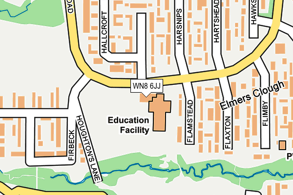
WN8 6JJ is located in the Tanhouse & Skelmersdale Town Centre electoral ward, within the local authority district of West Lancashire and the English Parliamentary constituency of West Lancashire. The Sub Integrated Care Board (ICB) Location is NHS Lancashire and South Cumbria ICB - 02G and the police force is Lancashire. This postcode has been in use since September 2008.


GetTheData
Source: OS OpenMap – Local (Ordnance Survey)
Source: OS VectorMap District (Ordnance Survey)
Licence: Open Government Licence (requires attribution)
| Easting | 349289 |
| Northing | 406484 |
| Latitude | 53.552522 |
| Longitude | -2.766898 |
GetTheData
Source: Open Postcode Geo
Licence: Open Government Licence
| Country | England |
| Postcode District | WN8 |
| ➜ WN8 open data dashboard ➜ See where WN8 is on a map ➜ Where is Skelmersdale? | |
GetTheData
Source: Land Registry Price Paid Data
Licence: Open Government Licence
Elevation or altitude of WN8 6JJ as distance above sea level:
| Metres | Feet | |
|---|---|---|
| Elevation | 70m | 230ft |
Elevation is measured from the approximate centre of the postcode, to the nearest point on an OS contour line from OS Terrain 50, which has contour spacing of ten vertical metres.
➜ How high above sea level am I? Find the elevation of your current position using your device's GPS.
GetTheData
Source: Open Postcode Elevation
Licence: Open Government Licence
| Ward | Tanhouse & Skelmersdale Town Centre |
| Constituency | West Lancashire |
GetTheData
Source: ONS Postcode Database
Licence: Open Government Licence
| January 2024 | Burglary | On or near Eversley | 430m |
| January 2024 | Burglary | On or near Eversley | 430m |
| January 2024 | Burglary | On or near Eversley | 430m |
| ➜ Get more crime data in our Crime section | |||
GetTheData
Source: data.police.uk
Licence: Open Government Licence
| Hallcroft (Birch Green Road) | Birch Green | 26m |
| Harsnips | Birch Green | 49m |
| Flimby (Birch Green Road) | Birch Green | 190m |
| Ferndale (Birch Green Road) | Birch Green | 233m |
| Flimby (Birch Green Road) | Birch Green | 246m |
| Upholland Station | 3.2km |
| Rainford Station | 4.2km |
| Parbold Station | 4.3km |
GetTheData
Source: NaPTAN
Licence: Open Government Licence
GetTheData
Source: ONS Postcode Database
Licence: Open Government Licence


➜ Get more ratings from the Food Standards Agency
GetTheData
Source: Food Standards Agency
Licence: FSA terms & conditions
| Last Collection | |||
|---|---|---|---|
| Location | Mon-Fri | Sat | Distance |
| Hawksclough | 17:45 | 11:00 | 243m |
| The Viking | 18:45 | 11:00 | 442m |
| The Viking (Business Box) | 443m | ||
GetTheData
Source: Dracos
Licence: Creative Commons Attribution-ShareAlike
| Facility | Distance |
|---|---|
| St John's Catholic Primary School (Skelmersdale) Flamstead, Skelmersdale Grass Pitches, Sports Hall | 37m |
| Bannatyne Health Club (Skelmersdale) Northway, Skelmersdale Swimming Pool, Health and Fitness Gym, Studio | 572m |
| Nye Bevan Pool Southway, Skelmersdale Swimming Pool, Health and Fitness Gym | 606m |
GetTheData
Source: Active Places
Licence: Open Government Licence
| School | Phase of Education | Distance |
|---|---|---|
| St John's Catholic Primary School, Skelmersdale Flamstead, Birch Green, Skelmersdale, WN8 6PF | Primary | 119m |
| Woodlands Community Primary School Heathgate, Birch Green, Skelmersdale, WN8 6QH | Primary | 453m |
| Elm Tree Community Primary School Elmers Wood Road, Tanhouse, Elm Tree Community Primary School, Skelmersdale, WN8 6SA | Not applicable | 662m |
GetTheData
Source: Edubase
Licence: Open Government Licence
The below table lists the International Territorial Level (ITL) codes (formerly Nomenclature of Territorial Units for Statistics (NUTS) codes) and Local Administrative Units (LAU) codes for WN8 6JJ:
| ITL 1 Code | Name |
|---|---|
| TLD | North West (England) |
| ITL 2 Code | Name |
| TLD4 | Lancashire |
| ITL 3 Code | Name |
| TLD47 | Chorley and West Lancashire |
| LAU 1 Code | Name |
| E07000127 | West Lancashire |
GetTheData
Source: ONS Postcode Directory
Licence: Open Government Licence
The below table lists the Census Output Area (OA), Lower Layer Super Output Area (LSOA), and Middle Layer Super Output Area (MSOA) for WN8 6JJ:
| Code | Name | |
|---|---|---|
| OA | E00129318 | |
| LSOA | E01025482 | West Lancashire 010D |
| MSOA | E02005313 | West Lancashire 010 |
GetTheData
Source: ONS Postcode Directory
Licence: Open Government Licence
| WN8 6PF | Flamstead | 120m |
| WN8 6QD | Hallcroft | 142m |
| WN8 6QB | Hallcroft | 161m |
| WN8 6QA | Harsnips | 176m |
| WN8 6PE | Flaxton | 188m |
| WN8 6PZ | Hartshead | 203m |
| WN8 6PL | Firbeck | 204m |
| WN8 6PD | Flimby | 224m |
| WN8 6PW | Firbeck | 273m |
| WN8 6PY | Hawksclough | 279m |
GetTheData
Source: Open Postcode Geo; Land Registry Price Paid Data
Licence: Open Government Licence