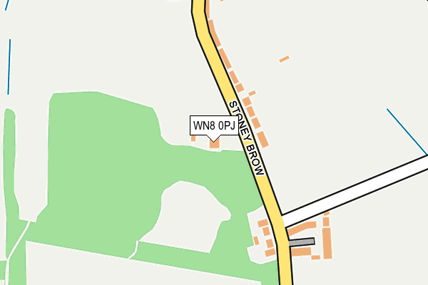
WN8 0PJ is located in the Up Holland electoral ward, within the local authority district of West Lancashire and the English Parliamentary constituency of West Lancashire. The Sub Integrated Care Board (ICB) Location is NHS Lancashire and South Cumbria ICB - 02G and the police force is Lancashire. This postcode has been in use since January 2010.


GetTheData
Source: OS OpenMap – Local (Ordnance Survey)
Source: OS VectorMap District (Ordnance Survey)
Licence: Open Government Licence (requires attribution)
| Easting | 351781 |
| Northing | 406919 |
| Latitude | 53.556683 |
| Longitude | -2.729355 |
GetTheData
Source: Open Postcode Geo
Licence: Open Government Licence
| Country | England |
| Postcode District | WN8 |
| ➜ WN8 open data dashboard ➜ See where WN8 is on a map ➜ Where is Roby Mill? | |
GetTheData
Source: Land Registry Price Paid Data
Licence: Open Government Licence
Elevation or altitude of WN8 0PJ as distance above sea level:
| Metres | Feet | |
|---|---|---|
| Elevation | 100m | 328ft |
Elevation is measured from the approximate centre of the postcode, to the nearest point on an OS contour line from OS Terrain 50, which has contour spacing of ten vertical metres.
➜ How high above sea level am I? Find the elevation of your current position using your device's GPS.
GetTheData
Source: Open Postcode Elevation
Licence: Open Government Licence
| Ward | Up Holland |
| Constituency | West Lancashire |
GetTheData
Source: ONS Postcode Database
Licence: Open Government Licence
| February 2022 | Burglary | On or near Knowles Farm Close | 49m |
| December 2021 | Burglary | On or near Knowles Farm Close | 49m |
| November 2021 | Burglary | On or near Gabriel Close | 461m |
| ➜ Get more crime data in our Crime section | |||
GetTheData
Source: data.police.uk
Licence: Open Government Licence
| Knowles Farm (Stoney Brow) | Roby Mill | 59m |
| Farley Lane (Roby Mill) | Roby Mill | 367m |
| Farley Lane (Roby Mill) | Roby Mill | 395m |
| Quarry (Stoney Brow) | Roby Mill | 502m |
| Stoney Brow | Roby Mill | 547m |
| Gathurst Station | 2.3km |
| Appley Bridge Station | 2.5km |
| Orrell Station | 3.2km |
GetTheData
Source: NaPTAN
Licence: Open Government Licence
GetTheData
Source: ONS Postcode Database
Licence: Open Government Licence


➜ Get more ratings from the Food Standards Agency
GetTheData
Source: Food Standards Agency
Licence: FSA terms & conditions
| Last Collection | |||
|---|---|---|---|
| Location | Mon-Fri | Sat | Distance |
| 12 Roby Mill | 18:30 | 11:00 | 390m |
| Ashurst Beacon | 16:40 | 11:00 | 1,628m |
| Upholland P O | 18:30 | 11:30 | 1,638m |
GetTheData
Source: Dracos
Licence: Creative Commons Attribution-ShareAlike
| Facility | Distance |
|---|---|
| St Teresa's Catholic Primary School College Road, Upholland, Skelmersdale Grass Pitches | 916m |
| Dean Wood Golf Club Lafford Lane, Upholland, Skelmersdale Golf | 1.2km |
| Beacon Park Golf Centre (Closed) Beacon Lane, Dalton, Wigan Golf | 1.3km |
GetTheData
Source: Active Places
Licence: Open Government Licence
| School | Phase of Education | Distance |
|---|---|---|
| Upholland Roby Mill CofE Voluntary Aided Primary School School Lane, Roby Mill, Up Holland, Skelmersdale, WN8 0QR | Primary | 278m |
| St Teresa's Catholic Primary School College Road, Up Holland, St Teresa's Catholic Primary School, Upholland, WN8 0PY | Primary | 840m |
| St Thomas the Martyr Voluntary Aided Church of England Primary School Highgate Road, Up Holland, Skelmersdale, WN8 0HX | Primary | 1.5km |
GetTheData
Source: Edubase
Licence: Open Government Licence
The below table lists the International Territorial Level (ITL) codes (formerly Nomenclature of Territorial Units for Statistics (NUTS) codes) and Local Administrative Units (LAU) codes for WN8 0PJ:
| ITL 1 Code | Name |
|---|---|
| TLD | North West (England) |
| ITL 2 Code | Name |
| TLD4 | Lancashire |
| ITL 3 Code | Name |
| TLD47 | Chorley and West Lancashire |
| LAU 1 Code | Name |
| E07000127 | West Lancashire |
GetTheData
Source: ONS Postcode Directory
Licence: Open Government Licence
The below table lists the Census Output Area (OA), Lower Layer Super Output Area (LSOA), and Middle Layer Super Output Area (MSOA) for WN8 0PJ:
| Code | Name | |
|---|---|---|
| OA | E00129589 | |
| LSOA | E01025540 | West Lancashire 015E |
| MSOA | E02005318 | West Lancashire 015 |
GetTheData
Source: ONS Postcode Directory
Licence: Open Government Licence
| WN8 0QE | Stoney Brow | 161m |
| WN8 0QR | School Lane | 276m |
| WN8 0QF | Roby Mill | 393m |
| WN8 0QG | Farley Lane | 482m |
| WN8 0QT | Walthew Green | 656m |
| WN8 0QB | Stoney Brow | 751m |
| WN8 0QP | Ayrefield Road | 806m |
| WN8 0QQ | Bank Top | 821m |
| WN8 0QY | Lafford Lane | 844m |
| WN8 7RX | Crow Lane | 888m |
GetTheData
Source: Open Postcode Geo; Land Registry Price Paid Data
Licence: Open Government Licence