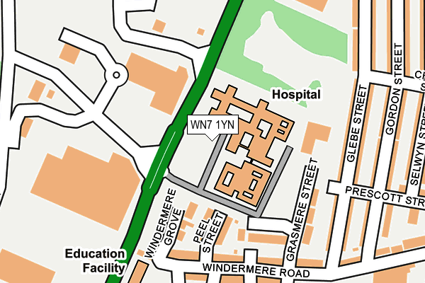
WN7 1YN is located in the Leigh Central & Higher Folds electoral ward, within the metropolitan district of Wigan and the English Parliamentary constituency of Leigh. The Sub Integrated Care Board (ICB) Location is NHS Greater Manchester ICB - 02H and the police force is Greater Manchester. This postcode has been in use since January 2015.


GetTheData
Source: OS OpenMap – Local (Ordnance Survey)
Source: OS VectorMap District (Ordnance Survey)
Licence: Open Government Licence (requires attribution)
| Easting | 365398 |
| Northing | 400650 |
| Latitude | 53.501414 |
| Longitude | -2.523117 |
GetTheData
Source: Open Postcode Geo
Licence: Open Government Licence
| Country | England |
| Postcode District | WN7 |
| ➜ WN7 open data dashboard ➜ See where WN7 is on a map ➜ Where is Leigh? | |
GetTheData
Source: Land Registry Price Paid Data
Licence: Open Government Licence
Elevation or altitude of WN7 1YN as distance above sea level:
| Metres | Feet | |
|---|---|---|
| Elevation | 30m | 98ft |
Elevation is measured from the approximate centre of the postcode, to the nearest point on an OS contour line from OS Terrain 50, which has contour spacing of ten vertical metres.
➜ How high above sea level am I? Find the elevation of your current position using your device's GPS.
GetTheData
Source: Open Postcode Elevation
Licence: Open Government Licence
| Ward | Leigh Central & Higher Folds |
| Constituency | Leigh |
GetTheData
Source: ONS Postcode Database
Licence: Open Government Licence
| March 2022 | Violence and sexual offences | On or near Evans Street | 423m |
| March 2022 | Violence and sexual offences | On or near Evans Street | 423m |
| ➜ Get more crime data in our Crime section | |||
GetTheData
Source: data.police.uk
Licence: Open Government Licence
| Leigh Rd/Chadwick St (Leigh Rd) | Lilford | 319m |
| Leigh Rd/Chadwick St (Leigh Rd) | Lilford | 327m |
| Leigh Rd/The Avenue (Leigh Rd) | Leigh | 362m |
| Kirkhall Ln/Gordon St (Kirkhall Ln) | Lilford | 385m |
| The Avenue/Leigh Rd (The Avenue) | Leigh | 391m |
| Hag Fold Station | 4.1km |
| Atherton Station | 4.3km |
| Daisy Hill Station | 4.3km |
GetTheData
Source: NaPTAN
Licence: Open Government Licence
GetTheData
Source: ONS Postcode Database
Licence: Open Government Licence


➜ Get more ratings from the Food Standards Agency
GetTheData
Source: Food Standards Agency
Licence: FSA terms & conditions
| Last Collection | |||
|---|---|---|---|
| Location | Mon-Fri | Sat | Distance |
| Romford Avenue | 18:15 | 11:30 | 316m |
| Charles Street | 18:10 | 11:35 | 476m |
| Leigh Branch Office | 19:15 | 12:30 | 624m |
GetTheData
Source: Dracos
Licence: Creative Commons Attribution-ShareAlike
| Facility | Distance |
|---|---|
| Leigh East Arlfc (Closed) Grasmere Street, Leigh Grass Pitches | 69m |
| Hilton Park (Closed) Kirkhall Lane, Leigh Grass Pitches | 76m |
| Everlast Gyms (Leigh) Parsonage Way, Leigh Health and Fitness Gym, Swimming Pool, Studio | 373m |
GetTheData
Source: Active Places
Licence: Open Government Licence
| School | Phase of Education | Distance |
|---|---|---|
| Sacred Heart Catholic Primary School Leigh Windermere Road, Leigh, WN7 1UX | Primary | 225m |
| Leigh Central Primary School Windermere Road, Leigh, WN7 1UY | Primary | 246m |
| Leigh St Mary's CofE Primary School Walmesley Road, Leigh, WN7 1YE | Primary | 343m |
GetTheData
Source: Edubase
Licence: Open Government Licence
The below table lists the International Territorial Level (ITL) codes (formerly Nomenclature of Territorial Units for Statistics (NUTS) codes) and Local Administrative Units (LAU) codes for WN7 1YN:
| ITL 1 Code | Name |
|---|---|
| TLD | North West (England) |
| ITL 2 Code | Name |
| TLD3 | Greater Manchester |
| ITL 3 Code | Name |
| TLD36 | Greater Manchester North West |
| LAU 1 Code | Name |
| E08000010 | Wigan |
GetTheData
Source: ONS Postcode Directory
Licence: Open Government Licence
The below table lists the Census Output Area (OA), Lower Layer Super Output Area (LSOA), and Middle Layer Super Output Area (MSOA) for WN7 1YN:
| Code | Name | |
|---|---|---|
| OA | E00032084 | |
| LSOA | E01006334 | Wigan 030C |
| MSOA | E02001316 | Wigan 030 |
GetTheData
Source: ONS Postcode Directory
Licence: Open Government Licence
| WN7 1XB | Grasmere Street | 143m |
| WN7 1RG | Prescott Street | 145m |
| WN7 1XF | Peel Street | 151m |
| WN7 1RQ | Glebe Street | 158m |
| WN7 1XQ | Windermere Grove | 161m |
| WN7 1RR | Chadwick Street | 162m |
| WN7 1RF | Glebe Street | 170m |
| WN7 1RW | Gordon Street | 181m |
| WN7 1UZ | Windermere Road | 184m |
| WN7 1WH | Windermere Road | 203m |
GetTheData
Source: Open Postcode Geo; Land Registry Price Paid Data
Licence: Open Government Licence