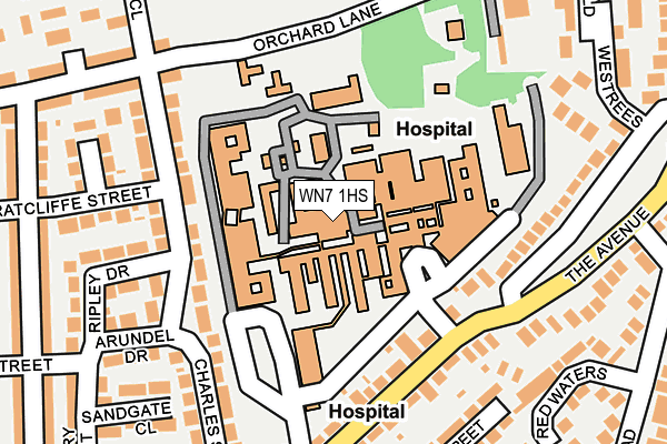
WN7 1HS is located in the Atherton South & Lilford electoral ward, within the metropolitan district of Wigan and the English Parliamentary constituency of Leigh. The Sub Integrated Care Board (ICB) Location is NHS Greater Manchester ICB - 02H and the police force is Greater Manchester. This postcode has been in use since January 1980.


GetTheData
Source: OS OpenMap – Local (Ordnance Survey)
Source: OS VectorMap District (Ordnance Survey)
Licence: Open Government Licence (requires attribution)
| Easting | 366121 |
| Northing | 400980 |
| Latitude | 53.504428 |
| Longitude | -2.512253 |
GetTheData
Source: Open Postcode Geo
Licence: Open Government Licence
| Country | England |
| Postcode District | WN7 |
| ➜ WN7 open data dashboard ➜ See where WN7 is on a map ➜ Where is Leigh? | |
GetTheData
Source: Land Registry Price Paid Data
Licence: Open Government Licence
Elevation or altitude of WN7 1HS as distance above sea level:
| Metres | Feet | |
|---|---|---|
| Elevation | 30m | 98ft |
Elevation is measured from the approximate centre of the postcode, to the nearest point on an OS contour line from OS Terrain 50, which has contour spacing of ten vertical metres.
➜ How high above sea level am I? Find the elevation of your current position using your device's GPS.
GetTheData
Source: Open Postcode Elevation
Licence: Open Government Licence
| Ward | Atherton South & Lilford |
| Constituency | Leigh |
GetTheData
Source: ONS Postcode Database
Licence: Open Government Licence
| December 2023 | Violence and sexual offences | On or near Orchard Close | 314m |
| December 2021 | Violence and sexual offences | On or near Orchard Close | 314m |
| April 2021 | Violence and sexual offences | On or near Orchard Close | 314m |
| ➜ Get more crime data in our Crime section | |||
GetTheData
Source: data.police.uk
Licence: Open Government Licence
| Leigh Infirmary (Internal Rd) | Leigh Infirmary | 110m |
| The Avenue/Leigh Infirmary (The Avenue) | Leigh Infirmary | 162m |
| The Avenue/Leigh Infirmary (The Avenue) | Leigh Infirmary | 165m |
| Leigh Infirmary Hsp Grounds (Hsp Rd) | Leigh Infirmary | 173m |
| The Avenue/Hanover St (The Avenue) | Leigh Infirmary | 263m |
| Hag Fold Station | 3.5km |
| Atherton Station | 3.5km |
| Daisy Hill Station | 3.9km |
GetTheData
Source: NaPTAN
Licence: Open Government Licence
GetTheData
Source: ONS Postcode Database
Licence: Open Government Licence


➜ Get more ratings from the Food Standards Agency
GetTheData
Source: Food Standards Agency
Licence: FSA terms & conditions
| Last Collection | |||
|---|---|---|---|
| Location | Mon-Fri | Sat | Distance |
| Richmonds Drive | 17:25 | 12:00 | 209m |
| Romford Avenue | 18:15 | 11:30 | 532m |
| Leigh Branch Office | 19:15 | 12:30 | 822m |
GetTheData
Source: Dracos
Licence: Creative Commons Attribution-ShareAlike
| Facility | Distance |
|---|---|
| Leigh Harriers Athletic Ground Track (Closed) Charles Street, Leigh Athletics, Health and Fitness Gym | 548m |
| Kings Park Christian Centre (Closed) Leigh Road, Leigh Grass Pitches | 652m |
| Hilton Park (Closed) Kirkhall Lane, Leigh Grass Pitches | 762m |
GetTheData
Source: Active Places
Licence: Open Government Licence
| School | Phase of Education | Distance |
|---|---|---|
| Leigh St John's CofE Primary Kirkhall Lane, Leigh, WN7 1RY | Primary | 484m |
| Leigh CofE Primary School Henrietta Street, Leigh, WN7 1LP | Primary | 727m |
| Sacred Heart Catholic Primary School Leigh Windermere Road, Leigh, WN7 1UX | Primary | 787m |
GetTheData
Source: Edubase
Licence: Open Government Licence
The below table lists the International Territorial Level (ITL) codes (formerly Nomenclature of Territorial Units for Statistics (NUTS) codes) and Local Administrative Units (LAU) codes for WN7 1HS:
| ITL 1 Code | Name |
|---|---|
| TLD | North West (England) |
| ITL 2 Code | Name |
| TLD3 | Greater Manchester |
| ITL 3 Code | Name |
| TLD36 | Greater Manchester North West |
| LAU 1 Code | Name |
| E08000010 | Wigan |
GetTheData
Source: ONS Postcode Directory
Licence: Open Government Licence
The below table lists the Census Output Area (OA), Lower Layer Super Output Area (LSOA), and Middle Layer Super Output Area (MSOA) for WN7 1HS:
| Code | Name | |
|---|---|---|
| OA | E00032115 | |
| LSOA | E01006330 | Wigan 031C |
| MSOA | E02001317 | Wigan 031 |
GetTheData
Source: ONS Postcode Directory
Licence: Open Government Licence
| WN7 1PT | Charles Street | 129m |
| WN7 1HR | The Avenue | 143m |
| WN7 1PP | Charles Street | 156m |
| WN7 1PU | Ripley Drive | 209m |
| WN7 1PR | Radcliffe Grove | 213m |
| WN7 1HF | Charles Street | 216m |
| WN7 1PX | Arundel Drive | 219m |
| WN7 1PS | Ratcliffe Street | 220m |
| WN7 1EJ | Orchard Lane | 221m |
| WN7 1JF | The Avenue | 230m |
GetTheData
Source: Open Postcode Geo; Land Registry Price Paid Data
Licence: Open Government Licence