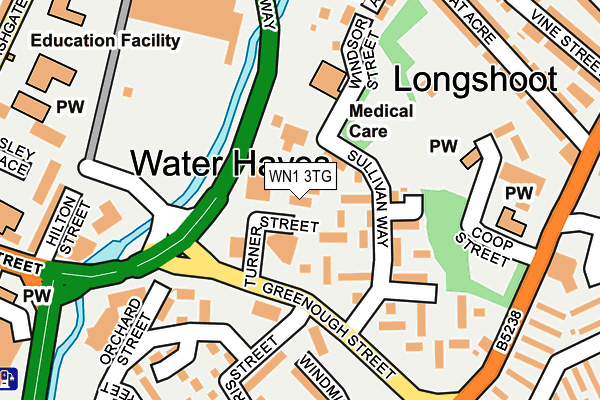
WN1 3TG is located in the Wigan Central electoral ward, within the metropolitan district of Wigan and the English Parliamentary constituency of Wigan. The Sub Integrated Care Board (ICB) Location is NHS Greater Manchester ICB - 02H and the police force is Greater Manchester. This postcode has been in use since January 1980.


GetTheData
Source: OS OpenMap – Local (Ordnance Survey)
Source: OS VectorMap District (Ordnance Survey)
Licence: Open Government Licence (requires attribution)
| Easting | 358785 |
| Northing | 406052 |
| Latitude | 53.549473 |
| Longitude | -2.623520 |
GetTheData
Source: Open Postcode Geo
Licence: Open Government Licence
| Country | England |
| Postcode District | WN1 |
| ➜ WN1 open data dashboard ➜ See where WN1 is on a map ➜ Where is Wigan? | |
GetTheData
Source: Land Registry Price Paid Data
Licence: Open Government Licence
Elevation or altitude of WN1 3TG as distance above sea level:
| Metres | Feet | |
|---|---|---|
| Elevation | 40m | 131ft |
Elevation is measured from the approximate centre of the postcode, to the nearest point on an OS contour line from OS Terrain 50, which has contour spacing of ten vertical metres.
➜ How high above sea level am I? Find the elevation of your current position using your device's GPS.
GetTheData
Source: Open Postcode Elevation
Licence: Open Government Licence
| Ward | Wigan Central |
| Constituency | Wigan |
GetTheData
Source: ONS Postcode Database
Licence: Open Government Licence
| February 2022 | Violence and sexual offences | On or near Warrington Lane | 468m |
| November 2021 | Violence and sexual offences | On or near Warrington Lane | 468m |
| ➜ Get more crime data in our Crime section | |||
GetTheData
Source: data.police.uk
Licence: Open Government Licence
| Scholes/Longshoot (Scholes) | Scholes | 235m |
| Scholes/Longshoot (Scholes) | Scholes | 253m |
| Scholes/Vauxhall Rd (Scholes) | Scholes | 294m |
| Scholfield Ln/Bryham St (Scholefield Ln) | Scholes | 328m |
| Wigan Infirmary | Wigan Infirmary | 341m |
| Wigan Wallgate Station | 0.8km |
| Wigan North Western Station | 0.9km |
| Ince (Manchester) Station | 1.4km |
GetTheData
Source: NaPTAN
Licence: Open Government Licence
GetTheData
Source: ONS Postcode Database
Licence: Open Government Licence


➜ Get more ratings from the Food Standards Agency
GetTheData
Source: Food Standards Agency
Licence: FSA terms & conditions
| Last Collection | |||
|---|---|---|---|
| Location | Mon-Fri | Sat | Distance |
| Swinley Road | 17:55 | 12:00 | 489m |
| Wrightington Street | 19:05 | 12:10 | 656m |
| Wrightington Street Bus Box | 659m | ||
GetTheData
Source: Dracos
Licence: Creative Commons Attribution-ShareAlike
| Facility | Distance |
|---|---|
| Jetts Wigan Standishgate, Wigan Health and Fitness Gym | 381m |
| Wigan Life Centre College Avenue, Wigan Health and Fitness Gym, Swimming Pool, Studio | 631m |
| Wigan International Swimming Pool (Closed) Rodney Street, Wigan Studio, Swimming Pool, Health and Fitness Gym | 675m |
GetTheData
Source: Active Places
Licence: Open Government Licence
| School | Phase of Education | Distance |
|---|---|---|
| Douglas Valley Nursery School Turner Street, Off Greenough Street, Wigan, WN1 3SU | Nursery | 43m |
| St Mary and St John Catholic Primary School Standishgate, Wigan, WN1 1XL | Primary | 283m |
| Mab's Cross Primary School Standishgate, Wigan, WN1 1XL | Primary | 319m |
GetTheData
Source: Edubase
Licence: Open Government Licence
The below table lists the International Territorial Level (ITL) codes (formerly Nomenclature of Territorial Units for Statistics (NUTS) codes) and Local Administrative Units (LAU) codes for WN1 3TG:
| ITL 1 Code | Name |
|---|---|
| TLD | North West (England) |
| ITL 2 Code | Name |
| TLD3 | Greater Manchester |
| ITL 3 Code | Name |
| TLD36 | Greater Manchester North West |
| LAU 1 Code | Name |
| E08000010 | Wigan |
GetTheData
Source: ONS Postcode Directory
Licence: Open Government Licence
The below table lists the Census Output Area (OA), Lower Layer Super Output Area (LSOA), and Middle Layer Super Output Area (MSOA) for WN1 3TG:
| Code | Name | |
|---|---|---|
| OA | E00032382 | |
| LSOA | E01006386 | Wigan 009C |
| MSOA | E02001295 | Wigan 009 |
GetTheData
Source: ONS Postcode Directory
Licence: Open Government Licence
| WN1 3TD | Riley Square | 69m |
| WN1 3TB | Sullivan Way | 74m |
| WN1 3TE | Oxford Court | 107m |
| WN1 3NT | Windsor Street | 157m |
| WN1 3TA | Lower Longshoot | 198m |
| WN1 3QS | Windmill Close | 200m |
| WN1 3RB | Morris Street | 202m |
| WN1 3NS | Wynard Avenue | 233m |
| WN1 3NU | Riverside Avenue | 242m |
| WN1 1XG | Hilton Street | 252m |
GetTheData
Source: Open Postcode Geo; Land Registry Price Paid Data
Licence: Open Government Licence