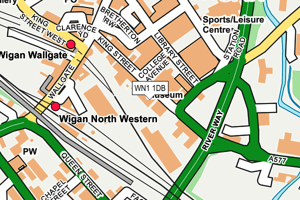
WN1 1DB is located in the Wigan Central electoral ward, within the metropolitan district of Wigan and the English Parliamentary constituency of Wigan. The Sub Integrated Care Board (ICB) Location is NHS Greater Manchester ICB - 02H and the police force is Greater Manchester. This postcode has been in use since January 1980.


GetTheData
Source: OS OpenMap – Local (Ordnance Survey)
Source: OS VectorMap District (Ordnance Survey)
Licence: Open Government Licence (requires attribution)
| Easting | 358301 |
| Northing | 405428 |
| Latitude | 53.543826 |
| Longitude | -2.630741 |
GetTheData
Source: Open Postcode Geo
Licence: Open Government Licence
| Country | England |
| Postcode District | WN1 |
| ➜ WN1 open data dashboard ➜ See where WN1 is on a map ➜ Where is Wigan? | |
GetTheData
Source: Land Registry Price Paid Data
Licence: Open Government Licence
Elevation or altitude of WN1 1DB as distance above sea level:
| Metres | Feet | |
|---|---|---|
| Elevation | 40m | 131ft |
Elevation is measured from the approximate centre of the postcode, to the nearest point on an OS contour line from OS Terrain 50, which has contour spacing of ten vertical metres.
➜ How high above sea level am I? Find the elevation of your current position using your device's GPS.
GetTheData
Source: Open Postcode Elevation
Licence: Open Government Licence
| Ward | Wigan Central |
| Constituency | Wigan |
GetTheData
Source: ONS Postcode Database
Licence: Open Government Licence
| February 2022 | Violence and sexual offences | On or near Rowbottom Square | 157m |
| February 2022 | Violence and sexual offences | On or near Warrington Lane | 403m |
| November 2021 | Violence and sexual offences | On or near Warrington Lane | 403m |
| ➜ Get more crime data in our Crime section | |||
GetTheData
Source: data.police.uk
Licence: Open Government Licence
| King St/Job Ctr (King St) | Wigan | 85m |
| King St/Wallgate (King St) | Wigan | 96m |
| Library St/Rodney St (Library St) | Wigan | 102m |
| Wallgate/Wallgate Stn (Wallgate) | Wigan | 186m |
| Wallgate/North Western Stn (Wallgate) | Wigan | 189m |
| Wigan North Western Station | 0.2km |
| Wigan Wallgate Station | 0.2km |
| Ince (Manchester) Station | 1.4km |
GetTheData
Source: NaPTAN
Licence: Open Government Licence
GetTheData
Source: ONS Postcode Database
Licence: Open Government Licence


➜ Get more ratings from the Food Standards Agency
GetTheData
Source: Food Standards Agency
Licence: FSA terms & conditions
| Last Collection | |||
|---|---|---|---|
| Location | Mon-Fri | Sat | Distance |
| Wigan Branch Office | 19:05 | 12:30 | 203m |
| Swinley Road | 17:55 | 12:00 | 307m |
| Wigan Delivery Office | 19:15 | 12:40 | 470m |
GetTheData
Source: Dracos
Licence: Creative Commons Attribution-ShareAlike
| Facility | Distance |
|---|---|
| Wigan International Swimming Pool (Closed) Rodney Street, Wigan Studio, Swimming Pool, Health and Fitness Gym | 123m |
| Xercise4less (Wigan) (Closed) Chapel Lane, Wigan Health and Fitness Gym, Studio | 139m |
| Wigan Life Centre College Avenue, Wigan Health and Fitness Gym, Swimming Pool, Studio | 197m |
GetTheData
Source: Active Places
Licence: Open Government Licence
| School | Phase of Education | Distance |
|---|---|---|
| Wigan and Leigh College PO Box 53, Parson's Walk, Wigan, WN1 1RS | 16 plus | 453m |
| The Deanery Church of England High School and Sixth Form College Frog Lane, Wigan, WN1 1HQ | Secondary | 630m |
| Progress Schools Wigan Wigan Youth Zone, Parsons Walk, Wigan, WN1 1RU | Not applicable | 665m |
GetTheData
Source: Edubase
Licence: Open Government Licence
The below table lists the International Territorial Level (ITL) codes (formerly Nomenclature of Territorial Units for Statistics (NUTS) codes) and Local Administrative Units (LAU) codes for WN1 1DB:
| ITL 1 Code | Name |
|---|---|
| TLD | North West (England) |
| ITL 2 Code | Name |
| TLD3 | Greater Manchester |
| ITL 3 Code | Name |
| TLD36 | Greater Manchester North West |
| LAU 1 Code | Name |
| E08000010 | Wigan |
GetTheData
Source: ONS Postcode Directory
Licence: Open Government Licence
The below table lists the Census Output Area (OA), Lower Layer Super Output Area (LSOA), and Middle Layer Super Output Area (MSOA) for WN1 1DB:
| Code | Name | |
|---|---|---|
| OA | E00032310 | |
| LSOA | E01006369 | Wigan 008C |
| MSOA | E02001294 | Wigan 008 |
GetTheData
Source: ONS Postcode Directory
Licence: Open Government Licence
| WN1 1BT | King Street | 43m |
| WN1 1DG | Rodney Street | 66m |
| WN1 1DY | King Street | 74m |
| WN1 1DF | College Avenue | 80m |
| WN1 1NU | Library Street | 87m |
| WN1 1BS | King Street | 116m |
| WN1 1DE | Arcade Street | 135m |
| WN1 1BE | Wallgate | 155m |
| WN1 1NN | Library Street | 161m |
| WN1 1XN | Westbridge Mews | 182m |
GetTheData
Source: Open Postcode Geo; Land Registry Price Paid Data
Licence: Open Government Licence