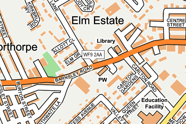
WF9 2AA is located in the South Elmsall and South Kirkby electoral ward, within the metropolitan district of Wakefield and the English Parliamentary constituency of Hemsworth. The Sub Integrated Care Board (ICB) Location is NHS West Yorkshire ICB - 03R and the police force is West Yorkshire. This postcode has been in use since January 1980.


GetTheData
Source: OS OpenMap – Local (Ordnance Survey)
Source: OS VectorMap District (Ordnance Survey)
Licence: Open Government Licence (requires attribution)
| Easting | 446750 |
| Northing | 411106 |
| Latitude | 53.594469 |
| Longitude | -1.295138 |
GetTheData
Source: Open Postcode Geo
Licence: Open Government Licence
| Country | England |
| Postcode District | WF9 |
| ➜ WF9 open data dashboard ➜ See where WF9 is on a map ➜ Where is South Elmsall? | |
GetTheData
Source: Land Registry Price Paid Data
Licence: Open Government Licence
Elevation or altitude of WF9 2AA as distance above sea level:
| Metres | Feet | |
|---|---|---|
| Elevation | 30m | 98ft |
Elevation is measured from the approximate centre of the postcode, to the nearest point on an OS contour line from OS Terrain 50, which has contour spacing of ten vertical metres.
➜ How high above sea level am I? Find the elevation of your current position using your device's GPS.
GetTheData
Source: Open Postcode Elevation
Licence: Open Government Licence
| Ward | South Elmsall And South Kirkby |
| Constituency | Hemsworth |
GetTheData
Source: ONS Postcode Database
Licence: Open Government Licence
| June 2022 | Criminal damage and arson | On or near Dearne Street | 54m |
| June 2022 | Shoplifting | On or near Dearne Street | 54m |
| June 2022 | Shoplifting | On or near Dearne Street | 54m |
| ➜ Get more crime data in our Crime section | |||
GetTheData
Source: data.police.uk
Licence: Open Government Licence
| Barnsley Rd Fire Station (Barnsley Road) | South Elmsall | 63m |
| Little Lane Allott Close (Little Lane) | South Elmsall | 92m |
| Carlton Road Carlton Gdns (Carlton Road) | South Elmsall | 133m |
| Barnsley Rd Fire Station (Barnsley Road) | South Elmsall | 151m |
| Carlton Road Carlton Gdns (Carlton Road) | South Elmsall | 163m |
| Moorthorpe Station | 0.7km |
| South Elmsall Station | 0.7km |
GetTheData
Source: NaPTAN
Licence: Open Government Licence
Estimated total energy consumption in WF9 2AA by fuel type, 2015.
| Consumption (kWh) | 101,150 |
|---|---|
| Meter count | 6 |
| Mean (kWh/meter) | 16,858 |
| Median (kWh/meter) | 14,943 |
GetTheData
Source: Postcode level gas estimates: 2015 (experimental)
Source: Postcode level electricity estimates: 2015 (experimental)
Licence: Open Government Licence
GetTheData
Source: ONS Postcode Database
Licence: Open Government Licence


➜ Get more ratings from the Food Standards Agency
GetTheData
Source: Food Standards Agency
Licence: FSA terms & conditions
| Last Collection | |||
|---|---|---|---|
| Location | Mon-Fri | Sat | Distance |
| Moorthorpe | 17:15 | 11:30 | 165m |
| Westfield Lane/Field Cres | 16:15 | 11:45 | 356m |
| South Elmsall P.o. | 17:30 | 11:45 | 465m |
GetTheData
Source: Dracos
Licence: Creative Commons Attribution-ShareAlike
| Facility | Distance |
|---|---|
| Minsthorpe Park Lower Northcroft, South Elmsall, Pontefract Grass Pitches | 553m |
| Frickley Colliery Welfare Cricket Club Westfield Lane, South Elmsall, Pontefract Grass Pitches | 574m |
| South Elmsall Town Council Social Centre (Closed) Westfield Lane, South Elmsall, Pontefract Sports Hall | 636m |
GetTheData
Source: Active Places
Licence: Open Government Licence
| School | Phase of Education | Distance |
|---|---|---|
| South Elmsall Carlton Junior and Infant School Carlton Road, South Elmsall, Pontefract, WF9 2QQ | Primary | 229m |
| St Joseph's Catholic Primary School, Moorthorpe Barnsley Road, Moorthorpe, Pontefract, WF9 2BP | Primary | 420m |
| Moorthorpe Primary School With Inclusion Resource Regent Street, Moorthorpe, Pontefract, WF9 2BL | Primary | 457m |
GetTheData
Source: Edubase
Licence: Open Government Licence
The below table lists the International Territorial Level (ITL) codes (formerly Nomenclature of Territorial Units for Statistics (NUTS) codes) and Local Administrative Units (LAU) codes for WF9 2AA:
| ITL 1 Code | Name |
|---|---|
| TLE | Yorkshire and The Humber |
| ITL 2 Code | Name |
| TLE4 | West Yorkshire |
| ITL 3 Code | Name |
| TLE45 | Wakefield |
| LAU 1 Code | Name |
| E08000036 | Wakefield |
GetTheData
Source: ONS Postcode Directory
Licence: Open Government Licence
The below table lists the Census Output Area (OA), Lower Layer Super Output Area (LSOA), and Middle Layer Super Output Area (MSOA) for WF9 2AA:
| Code | Name | |
|---|---|---|
| OA | E00059863 | |
| LSOA | E01011869 | Wakefield 043B |
| MSOA | E02002480 | Wakefield 043 |
GetTheData
Source: ONS Postcode Directory
Licence: Open Government Licence
| WF9 2AD | Barnsley Road | 35m |
| WF9 2QZ | Valley Street | 109m |
| WF9 2NJ | Little Lane | 124m |
| WF9 2RD | Exchange Street | 146m |
| WF9 2XA | Allott Close | 148m |
| WF9 2QR | Valley Street | 160m |
| WF9 2AE | Barnsley Road | 172m |
| WF9 2QW | Barnsley Road | 178m |
| WF9 2AL | Barnsley Road | 186m |
| WF9 2RF | Barnsley Road | 188m |
GetTheData
Source: Open Postcode Geo; Land Registry Price Paid Data
Licence: Open Government Licence