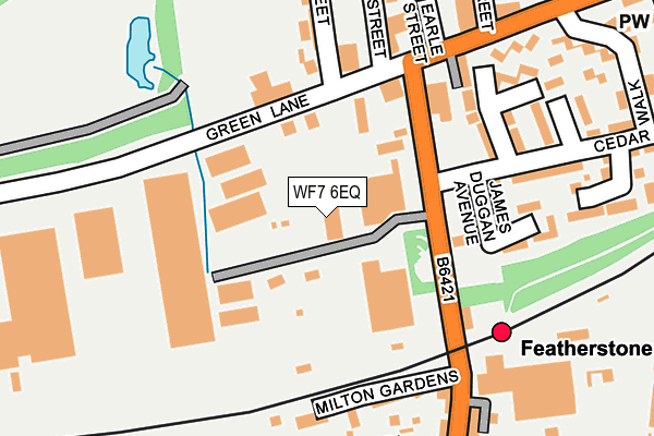
WF7 6EQ is located in the Featherstone electoral ward, within the metropolitan district of Wakefield and the English Parliamentary constituency of Hemsworth. The Sub Integrated Care Board (ICB) Location is NHS West Yorkshire ICB - 03R and the police force is West Yorkshire. This postcode has been in use since April 1987.


GetTheData
Source: OS OpenMap – Local (Ordnance Survey)
Source: OS VectorMap District (Ordnance Survey)
Licence: Open Government Licence (requires attribution)
| Easting | 442408 |
| Northing | 420621 |
| Latitude | 53.680355 |
| Longitude | -1.359442 |
GetTheData
Source: Open Postcode Geo
Licence: Open Government Licence
| Country | England |
| Postcode District | WF7 |
| ➜ WF7 open data dashboard ➜ See where WF7 is on a map ➜ Where is Featherstone? | |
GetTheData
Source: Land Registry Price Paid Data
Licence: Open Government Licence
Elevation or altitude of WF7 6EQ as distance above sea level:
| Metres | Feet | |
|---|---|---|
| Elevation | 50m | 164ft |
Elevation is measured from the approximate centre of the postcode, to the nearest point on an OS contour line from OS Terrain 50, which has contour spacing of ten vertical metres.
➜ How high above sea level am I? Find the elevation of your current position using your device's GPS.
GetTheData
Source: Open Postcode Elevation
Licence: Open Government Licence
| Ward | Featherstone |
| Constituency | Hemsworth |
GetTheData
Source: ONS Postcode Database
Licence: Open Government Licence
| January 2024 | Violence and sexual offences | On or near Albert Street | 488m |
| January 2024 | Criminal damage and arson | On or near Albert Street | 488m |
| January 2024 | Violence and sexual offences | On or near Albert Street | 488m |
| ➜ Get more crime data in our Crime section | |||
GetTheData
Source: data.police.uk
Licence: Open Government Licence
| Station Lane Cedar Walk (Station Lane) | Featherstone | 38m |
| Station Lane Cedar Walk (Station Lane) | Featherstone | 60m |
| Green Ln Market Street (Green Lane) | Featherstone | 187m |
| Green Ln Market Street (Green Lane) | Featherstone | 199m |
| Station Lane Maxwell St (Station Lane) | Featherstone | 220m |
| Featherstone Station | 0.2km |
| Streethouse Station | 2.7km |
| Pontefract Tanshelf Station | 3.1km |
GetTheData
Source: NaPTAN
Licence: Open Government Licence
GetTheData
Source: ONS Postcode Database
Licence: Open Government Licence


➜ Get more ratings from the Food Standards Agency
GetTheData
Source: Food Standards Agency
Licence: FSA terms & conditions
| Last Collection | |||
|---|---|---|---|
| Location | Mon-Fri | Sat | Distance |
| 17 Green Lane / Greenside | 16:45 | 12:15 | 252m |
| Featherstone P.o. | 17:30 | 12:00 | 332m |
| Precinct | 17:00 | 12:15 | 522m |
GetTheData
Source: Dracos
Licence: Creative Commons Attribution-ShareAlike
| Facility | Distance |
|---|---|
| Bodyworks Green Lane, Featherstone, Pontefract Health and Fitness Gym | 159m |
| Featherstone Indoor Bowls Club (Closed) Station Lane, Featherstone, Pontefract Indoor Bowls | 239m |
| Featherstone Rovers (Millennium Stadium) Post Office Road, Featherstone, Pontefract Grass Pitches | 416m |
GetTheData
Source: Active Places
Licence: Open Government Licence
| School | Phase of Education | Distance |
|---|---|---|
| Featherstone Purston St Thomas Church of England Voluntary Controlled Junior School George Street, Featherstone, Pontefract, WF7 5BG | Primary | 573m |
| Featherstone North Featherstone Junior and Infant School Gordon Street, Featherstone, Pontefract, WF7 6LW | Primary | 802m |
| Featherstone Purston Infant School Nunns Lane, Featherstone, Purston Infant School, Nunns Lane, Pontefract, WF7 5HF | Primary | 810m |
GetTheData
Source: Edubase
Licence: Open Government Licence
The below table lists the International Territorial Level (ITL) codes (formerly Nomenclature of Territorial Units for Statistics (NUTS) codes) and Local Administrative Units (LAU) codes for WF7 6EQ:
| ITL 1 Code | Name |
|---|---|
| TLE | Yorkshire and The Humber |
| ITL 2 Code | Name |
| TLE4 | West Yorkshire |
| ITL 3 Code | Name |
| TLE45 | Wakefield |
| LAU 1 Code | Name |
| E08000036 | Wakefield |
GetTheData
Source: ONS Postcode Directory
Licence: Open Government Licence
The below table lists the Census Output Area (OA), Lower Layer Super Output Area (LSOA), and Middle Layer Super Output Area (MSOA) for WF7 6EQ:
| Code | Name | |
|---|---|---|
| OA | E00059381 | |
| LSOA | E01011781 | Wakefield 027C |
| MSOA | E02002464 | Wakefield 027 |
GetTheData
Source: ONS Postcode Directory
Licence: Open Government Licence
| WF7 6EG | Station Lane | 133m |
| WF7 6EH | Green Lane | 134m |
| WF7 6JF | Back Duke Street | 136m |
| WF7 6JN | Cedar Walk | 164m |
| WF7 5DQ | Milton Gardens | 201m |
| WF7 6JH | Westerman Close | 206m |
| WF7 6EU | Pretoria Street | 209m |
| WF7 5EL | Railway Terrace | 214m |
| WF7 6NS | Riverside Court | 227m |
| WF7 5BA | Station Lane | 231m |
GetTheData
Source: Open Postcode Geo; Land Registry Price Paid Data
Licence: Open Government Licence