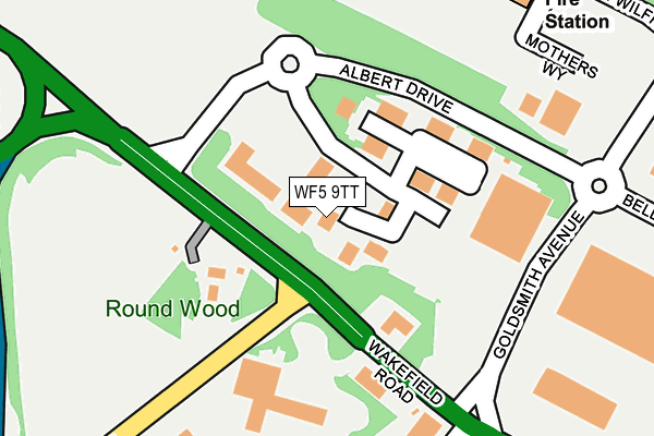
WF5 9TT is located in the Wrenthorpe and Outwood West electoral ward, within the metropolitan district of Wakefield and the English Parliamentary constituency of Morley and Outwood. The Sub Integrated Care Board (ICB) Location is NHS West Yorkshire ICB - 03R and the police force is West Yorkshire. This postcode has been in use since September 2010.


GetTheData
Source: OS OpenMap – Local (Ordnance Survey)
Source: OS VectorMap District (Ordnance Survey)
Licence: Open Government Licence (requires attribution)
| Easting | 429879 |
| Northing | 420735 |
| Latitude | 53.682242 |
| Longitude | -1.549106 |
GetTheData
Source: Open Postcode Geo
Licence: Open Government Licence
| Country | England |
| Postcode District | WF5 |
| ➜ WF5 open data dashboard ➜ See where WF5 is on a map ➜ Where is Wakefield? | |
GetTheData
Source: Land Registry Price Paid Data
Licence: Open Government Licence
Elevation or altitude of WF5 9TT as distance above sea level:
| Metres | Feet | |
|---|---|---|
| Elevation | 90m | 295ft |
Elevation is measured from the approximate centre of the postcode, to the nearest point on an OS contour line from OS Terrain 50, which has contour spacing of ten vertical metres.
➜ How high above sea level am I? Find the elevation of your current position using your device's GPS.
GetTheData
Source: Open Postcode Elevation
Licence: Open Government Licence
| Ward | Wrenthorpe And Outwood West |
| Constituency | Morley And Outwood |
GetTheData
Source: ONS Postcode Database
Licence: Open Government Licence
| June 2022 | Other theft | On or near Petrol Station | 87m |
| June 2022 | Other theft | On or near Petrol Station | 87m |
| June 2022 | Other theft | On or near Petrol Station | 87m |
| ➜ Get more crime data in our Crime section | |||
GetTheData
Source: data.police.uk
Licence: Open Government Licence
| Wakefield Rd Queens Drive (Wakefield Road) | Roundwood | 114m |
| Queens Drive Wakefield Rd (Queens Drive) | Roundwood | 127m |
| Queens Drive Wakefield Rd (Queen's Drive) | Roundwood | 166m |
| Wakefield Rd Queens Drive (Wakefield Road) | Roundwood | 237m |
| Malt Shovel Ph (Wakefield Road) | Lupset | 313m |
| Wakefield Westgate Station | 2.8km |
| Wakefield Kirkgate Station | 4km |
| Outwood Station | 4.5km |
GetTheData
Source: NaPTAN
Licence: Open Government Licence
GetTheData
Source: ONS Postcode Database
Licence: Open Government Licence


➜ Get more ratings from the Food Standards Agency
GetTheData
Source: Food Standards Agency
Licence: FSA terms & conditions
| Last Collection | |||
|---|---|---|---|
| Location | Mon-Fri | Sat | Distance |
| Gargrave Place | 17:30 | 11:00 | 619m |
| Flushdike School Wakefield Road | 17:30 | 11:00 | 967m |
| 126 Broadway/Hall Road | 17:30 | 11:00 | 1,032m |
GetTheData
Source: Dracos
Licence: Creative Commons Attribution-ShareAlike
| Facility | Distance |
|---|---|
| Total Fitness (Wakefield) Fryers Way, Ossett Health and Fitness Gym, Swimming Pool, Studio | 151m |
| Thornes Junior Football Club Queens Drive, Ossett Grass Pitches | 230m |
| Haggs Hill Parkfield Drive, Ossett Grass Pitches | 743m |
GetTheData
Source: Active Places
Licence: Open Government Licence
| School | Phase of Education | Distance |
|---|---|---|
| Ossett Flushdyke Junior and Infant School Wakefield Road, Flushdyke, Ossett, WF5 9AN | Primary | 981m |
| Ossett South Parade Primary Fairfield Road, South Parade, Ossett, Wakefield, WF5 0DZ | Primary | 1.2km |
| English Martyrs Catholic Primary School, A Voluntary Academy Dewsbury Road, Wakefield, WF2 9DD | Primary | 1.3km |
GetTheData
Source: Edubase
Licence: Open Government Licence
The below table lists the International Territorial Level (ITL) codes (formerly Nomenclature of Territorial Units for Statistics (NUTS) codes) and Local Administrative Units (LAU) codes for WF5 9TT:
| ITL 1 Code | Name |
|---|---|
| TLE | Yorkshire and The Humber |
| ITL 2 Code | Name |
| TLE4 | West Yorkshire |
| ITL 3 Code | Name |
| TLE45 | Wakefield |
| LAU 1 Code | Name |
| E08000036 | Wakefield |
GetTheData
Source: ONS Postcode Directory
Licence: Open Government Licence
The below table lists the Census Output Area (OA), Lower Layer Super Output Area (LSOA), and Middle Layer Super Output Area (MSOA) for WF5 9TT:
| Code | Name | |
|---|---|---|
| OA | E00059937 | |
| LSOA | E01011889 | Wakefield 022A |
| MSOA | E02002459 | Wakefield 022 |
GetTheData
Source: ONS Postcode Directory
Licence: Open Government Licence
| WF5 9TJ | Fryers Way | 91m |
| WF5 9AE | Wakefield Road | 122m |
| WF5 9BE | Queens Drive | 146m |
| WF5 9AB | Wakefield Road | 296m |
| WF5 9AD | Wakefield Road | 301m |
| WF2 9AZ | Foreman Road | 480m |
| WF2 9DP | Clay Close | 481m |
| WF2 9DU | Dewsbury Road | 506m |
| WF2 8AU | Broadway | 512m |
| WF2 8AT | Lindsay Avenue | 529m |
GetTheData
Source: Open Postcode Geo; Land Registry Price Paid Data
Licence: Open Government Licence