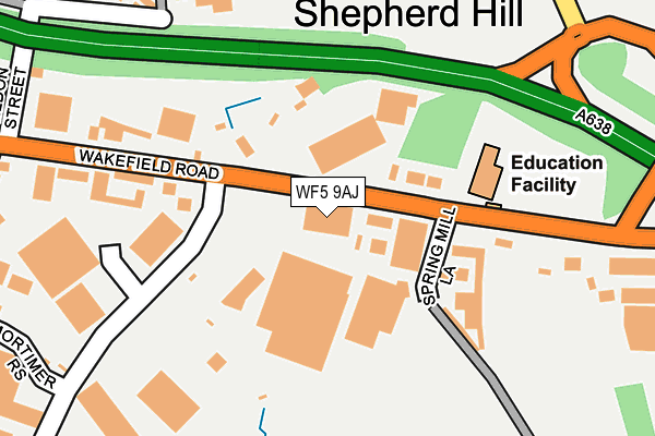
WF5 9AJ is located in the Ossett electoral ward, within the metropolitan district of Wakefield and the English Parliamentary constituency of Wakefield. The Sub Integrated Care Board (ICB) Location is NHS West Yorkshire ICB - 03R and the police force is West Yorkshire. This postcode has been in use since June 1997.


GetTheData
Source: OS OpenMap – Local (Ordnance Survey)
Source: OS VectorMap District (Ordnance Survey)
Licence: Open Government Licence (requires attribution)
| Easting | 428807 |
| Northing | 421046 |
| Latitude | 53.685081 |
| Longitude | -1.565305 |
GetTheData
Source: Open Postcode Geo
Licence: Open Government Licence
| Country | England |
| Postcode District | WF5 |
| ➜ WF5 open data dashboard ➜ See where WF5 is on a map ➜ Where is Ossett? | |
GetTheData
Source: Land Registry Price Paid Data
Licence: Open Government Licence
Elevation or altitude of WF5 9AJ as distance above sea level:
| Metres | Feet | |
|---|---|---|
| Elevation | 80m | 262ft |
Elevation is measured from the approximate centre of the postcode, to the nearest point on an OS contour line from OS Terrain 50, which has contour spacing of ten vertical metres.
➜ How high above sea level am I? Find the elevation of your current position using your device's GPS.
GetTheData
Source: Open Postcode Elevation
Licence: Open Government Licence
| Ward | Ossett |
| Constituency | Wakefield |
GetTheData
Source: ONS Postcode Database
Licence: Open Government Licence
| June 2022 | Other theft | On or near B6129 | 258m |
| June 2022 | Other theft | On or near Mortimer Rise | 302m |
| June 2022 | Public order | On or near Whitley Spring Crescent | 371m |
| ➜ Get more crime data in our Crime section | |||
GetTheData
Source: data.police.uk
Licence: Open Government Licence
| Wakefield Rd Milner Way (Wakefield Road) | Flushdyke | 28m |
| Wakefield Rd Spring Mill Lane (Wakefield Road) | Flushdyke | 45m |
| Wakefield Road School (Wakefield Road) | Flushdyke | 158m |
| Wakefield Rd J & I School (Wakefield Road) | Flushdyke | 194m |
| Wakefield Rd Spring Mill Lane (Wakefield Road) | Flushdyke | 209m |
| Wakefield Westgate Station | 3.9km |
| Dewsbury Station | 4.5km |
| Batley Station | 4.7km |
GetTheData
Source: NaPTAN
Licence: Open Government Licence
GetTheData
Source: ONS Postcode Database
Licence: Open Government Licence


➜ Get more ratings from the Food Standards Agency
GetTheData
Source: Food Standards Agency
Licence: FSA terms & conditions
| Last Collection | |||
|---|---|---|---|
| Location | Mon-Fri | Sat | Distance |
| Flushdike School Wakefield Road | 17:30 | 11:00 | 159m |
| Flushdike | 17:00 | 11:00 | 393m |
| Broadgate | 17:15 | 11:30 | 591m |
GetTheData
Source: Dracos
Licence: Creative Commons Attribution-ShareAlike
| Facility | Distance |
|---|---|
| Springmill Playing Fields Spring Mill Lane, Ossett Grass Pitches | 250m |
| Ingfield Prospect Road, Ossett Grass Pitches, Artificial Grass Pitch | 898m |
| Church Street Recreation Ground Dale Street, Ossett Grass Pitches | 946m |
GetTheData
Source: Active Places
Licence: Open Government Licence
| School | Phase of Education | Distance |
|---|---|---|
| Ossett Flushdyke Junior and Infant School Wakefield Road, Flushdyke, Ossett, WF5 9AN | Primary | 156m |
| Towngate Primary Academy Whitley Spring Road, Ossett, WF5 0QA | Primary | 420m |
| The Grange School 2 Milner Way, Ossett, West Yorkshire, Wakefield, WF5 9JE | Not applicable | 535m |
GetTheData
Source: Edubase
Licence: Open Government Licence
The below table lists the International Territorial Level (ITL) codes (formerly Nomenclature of Territorial Units for Statistics (NUTS) codes) and Local Administrative Units (LAU) codes for WF5 9AJ:
| ITL 1 Code | Name |
|---|---|
| TLE | Yorkshire and The Humber |
| ITL 2 Code | Name |
| TLE4 | West Yorkshire |
| ITL 3 Code | Name |
| TLE45 | Wakefield |
| LAU 1 Code | Name |
| E08000036 | Wakefield |
GetTheData
Source: ONS Postcode Directory
Licence: Open Government Licence
The below table lists the Census Output Area (OA), Lower Layer Super Output Area (LSOA), and Middle Layer Super Output Area (MSOA) for WF5 9AJ:
| Code | Name | |
|---|---|---|
| OA | E00059657 | |
| LSOA | E01011827 | Wakefield 021E |
| MSOA | E02002458 | Wakefield 021 |
GetTheData
Source: ONS Postcode Directory
Licence: Open Government Licence
| WF5 9AR | Wakefield Road | 83m |
| WF5 9JX | Wakefield Road | 198m |
| WF5 9AQ | Wakefield Road | 249m |
| WF5 9JT | St Oswalds Place | 314m |
| WF5 0RF | Whitley Spring Crescent | 351m |
| WF5 9LB | Wakefield Road | 431m |
| WF5 0RE | Whitley Spring Crescent | 445m |
| WF5 0QA | Whitley Spring Road | 451m |
| WF5 9JA | Wakefield Road | 477m |
| WF5 0QB | Spring View | 496m |
GetTheData
Source: Open Postcode Geo; Land Registry Price Paid Data
Licence: Open Government Licence