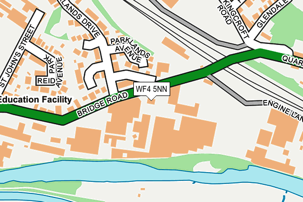
WF4 5NN lies on Bridge Road in Horbury, Wakefield. WF4 5NN is located in the Horbury and South Ossett electoral ward, within the metropolitan district of Wakefield and the English Parliamentary constituency of Wakefield. The Sub Integrated Care Board (ICB) Location is NHS West Yorkshire ICB - 03R and the police force is West Yorkshire. This postcode has been in use since December 1995.


GetTheData
Source: OS OpenMap – Local (Ordnance Survey)
Source: OS VectorMap District (Ordnance Survey)
Licence: Open Government Licence (requires attribution)
| Easting | 428239 |
| Northing | 417995 |
| Latitude | 53.657706 |
| Longitude | -1.574184 |
GetTheData
Source: Open Postcode Geo
Licence: Open Government Licence
| Street | Bridge Road |
| Locality | Horbury |
| Town/City | Wakefield |
| Country | England |
| Postcode District | WF4 |
➜ See where WF4 is on a map ➜ Where is Horbury? | |
GetTheData
Source: Land Registry Price Paid Data
Licence: Open Government Licence
Elevation or altitude of WF4 5NN as distance above sea level:
| Metres | Feet | |
|---|---|---|
| Elevation | 30m | 98ft |
Elevation is measured from the approximate centre of the postcode, to the nearest point on an OS contour line from OS Terrain 50, which has contour spacing of ten vertical metres.
➜ How high above sea level am I? Find the elevation of your current position using your device's GPS.
GetTheData
Source: Open Postcode Elevation
Licence: Open Government Licence
| Ward | Horbury And South Ossett |
| Constituency | Wakefield |
GetTheData
Source: ONS Postcode Database
Licence: Open Government Licence
| Bridge Rd Holyoake Terrace (Bridge Road) | Horbury Bridge | 19m |
| Bridge Rd Holyoake Terrace (Bridge Road) | Horbury Bridge | 63m |
| Bridge Road Parklands Dr (Bridge Road) | Horbury Bridge | 205m |
| Bridge Road Parklands Dr (Bridge Road) | Horbury Bridge | 207m |
| Bridge Road Netherton Ln (Bridge Road) | Horbury Bridge | 255m |
| Wakefield Westgate Station | 5.3km |
| Dewsbury Station | 5.5km |
GetTheData
Source: NaPTAN
Licence: Open Government Licence
GetTheData
Source: ONS Postcode Database
Licence: Open Government Licence


➜ Get more ratings from the Food Standards Agency
GetTheData
Source: Food Standards Agency
Licence: FSA terms & conditions
| Last Collection | |||
|---|---|---|---|
| Location | Mon-Fri | Sat | Distance |
| Horbury Bridge P.o. | 17:30 | 11:30 | 181m |
| First Avenue | 17:30 | 11:30 | 447m |
| Water Lane | 17:00 | 12:15 | 536m |
GetTheData
Source: Dracos
Licence: Creative Commons Attribution-ShareAlike
| Risk of WF4 5NN flooding from rivers and sea | High |
| ➜ WF4 5NN flood map | |
GetTheData
Source: Open Flood Risk by Postcode
Licence: Open Government Licence
The below table lists the International Territorial Level (ITL) codes (formerly Nomenclature of Territorial Units for Statistics (NUTS) codes) and Local Administrative Units (LAU) codes for WF4 5NN:
| ITL 1 Code | Name |
|---|---|
| TLE | Yorkshire and The Humber |
| ITL 2 Code | Name |
| TLE4 | West Yorkshire |
| ITL 3 Code | Name |
| TLE45 | Wakefield |
| LAU 1 Code | Name |
| E08000036 | Wakefield |
GetTheData
Source: ONS Postcode Directory
Licence: Open Government Licence
The below table lists the Census Output Area (OA), Lower Layer Super Output Area (LSOA), and Middle Layer Super Output Area (MSOA) for WF4 5NN:
| Code | Name | |
|---|---|---|
| OA | E00059493 | |
| LSOA | E01011800 | Wakefield 029F |
| MSOA | E02002466 | Wakefield 029 |
GetTheData
Source: ONS Postcode Directory
Licence: Open Government Licence
| WF4 5NS | Holy Oake Terrace | 44m |
| WF4 5NR | Bridge Road | 50m |
| WF4 5NT | Bridge Road | 83m |
| WF4 5NX | Greigs Yard | 102m |
| WF4 5NP | The Island | 105m |
| WF4 5PA | Reid Park Avenue | 105m |
| WF4 5NU | St Johns Street | 151m |
| WF4 5BS | Parklands Crescent | 153m |
| WF4 5PS | Bridge Road | 174m |
| WF4 5BT | Parklands Court | 195m |
GetTheData
Source: Open Postcode Geo; Land Registry Price Paid Data
Licence: Open Government Licence