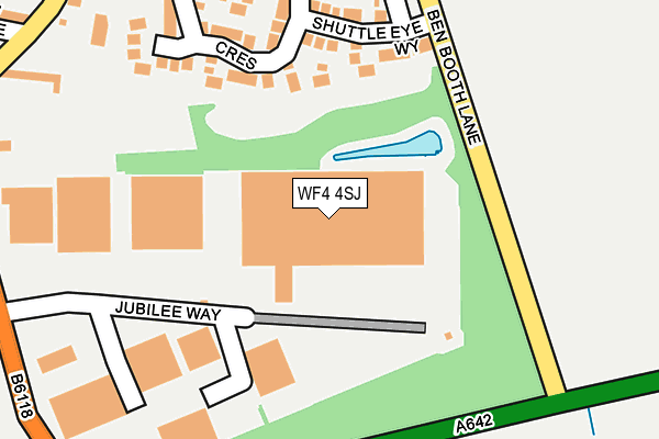
WF4 4SJ is located in the Kirkburton electoral ward, within the metropolitan district of Kirklees and the English Parliamentary constituency of Dewsbury. The Sub Integrated Care Board (ICB) Location is NHS West Yorkshire ICB - X2C4Y and the police force is West Yorkshire. This postcode has been in use since April 2003.


GetTheData
Source: OS OpenMap – Local (Ordnance Survey)
Source: OS VectorMap District (Ordnance Survey)
Licence: Open Government Licence (requires attribution)
| Easting | 422412 |
| Northing | 415753 |
| Latitude | 53.637820 |
| Longitude | -1.662510 |
GetTheData
Source: Open Postcode Geo
Licence: Open Government Licence
| Country | England |
| Postcode District | WF4 |
| ➜ WF4 open data dashboard ➜ See where WF4 is on a map ➜ Where is Grange Moor? | |
GetTheData
Source: Land Registry Price Paid Data
Licence: Open Government Licence
Elevation or altitude of WF4 4SJ as distance above sea level:
| Metres | Feet | |
|---|---|---|
| Elevation | 230m | 755ft |
Elevation is measured from the approximate centre of the postcode, to the nearest point on an OS contour line from OS Terrain 50, which has contour spacing of ten vertical metres.
➜ How high above sea level am I? Find the elevation of your current position using your device's GPS.
GetTheData
Source: Open Postcode Elevation
Licence: Open Government Licence
| Ward | Kirkburton |
| Constituency | Dewsbury |
GetTheData
Source: ONS Postcode Database
Licence: Open Government Licence
| December 2023 | Other theft | On or near Greenfield Crescent | 251m |
| November 2022 | Violence and sexual offences | On or near Greenfield Crescent | 251m |
| August 2022 | Violence and sexual offences | On or near Greenfield Crescent | 251m |
| ➜ Get more crime data in our Crime section | |||
GetTheData
Source: data.police.uk
Licence: Open Government Licence
| Liley Ln Jubilee Way (Liley Lane) | Grange Moor | 314m |
| Liley Ln Jubilee Way (Liley Lane) | Grange Moor | 325m |
| New Inn Ph (Briestfield Road) | Grange Moor | 344m |
| New Inn Ph (Liley Lane) | Grange Moor | 372m |
| Wakefield Road Blacksmith Arms (Wakefield Road) | Grange Moor | 406m |
| Ravensthorpe Station | 4.2km |
| Mirfield Station | 4.2km |
| Stocksmoor Station | 6.3km |
GetTheData
Source: NaPTAN
Licence: Open Government Licence
GetTheData
Source: ONS Postcode Database
Licence: Open Government Licence


➜ Get more ratings from the Food Standards Agency
GetTheData
Source: Food Standards Agency
Licence: FSA terms & conditions
| Last Collection | |||
|---|---|---|---|
| Location | Mon-Fri | Sat | Distance |
| Woodnook | 16:30 | 11:15 | 453m |
| Grange Moor Post Office | 16:45 | 11:15 | 545m |
| Flockton Moor | 16:15 | 11:00 | 1,552m |
GetTheData
Source: Dracos
Licence: Creative Commons Attribution-ShareAlike
| Facility | Distance |
|---|---|
| Grange Moor Football Ground Liley Lane, Grange Moor, Huddersfield Grass Pitches | 413m |
| Hill Top Park Side, Flockton, Wakefield Grass Pitches | 1.7km |
| Flockton Cricket Club Park Side, Flockton, Wakefield Grass Pitches | 1.7km |
GetTheData
Source: Active Places
Licence: Open Government Licence
| School | Phase of Education | Distance |
|---|---|---|
| Grange Moor Primary School Liley Lane, Grange Moor, Wakefield, WF4 4EW | Primary | 426m |
| Flockton CofE (C) First School Flockton First School, Barnsley Road, Flockton, Wakefield, WF4 4DH | Primary | 1.8km |
| Emley First School School Lane, Emley, Huddersfield, HD8 9RT | Primary | 3.3km |
GetTheData
Source: Edubase
Licence: Open Government Licence
The below table lists the International Territorial Level (ITL) codes (formerly Nomenclature of Territorial Units for Statistics (NUTS) codes) and Local Administrative Units (LAU) codes for WF4 4SJ:
| ITL 1 Code | Name |
|---|---|
| TLE | Yorkshire and The Humber |
| ITL 2 Code | Name |
| TLE4 | West Yorkshire |
| ITL 3 Code | Name |
| TLE44 | Calderdale and Kirklees |
| LAU 1 Code | Name |
| E08000034 | Kirklees |
GetTheData
Source: ONS Postcode Directory
Licence: Open Government Licence
The below table lists the Census Output Area (OA), Lower Layer Super Output Area (LSOA), and Middle Layer Super Output Area (MSOA) for WF4 4SJ:
| Code | Name | |
|---|---|---|
| OA | E00056394 | |
| LSOA | E01011193 | Kirklees 046C |
| MSOA | E02002316 | Kirklees 046 |
GetTheData
Source: ONS Postcode Directory
Licence: Open Government Licence
| WF4 4UN | Shuttle Eye Way | 160m |
| WF4 4TD | Jubilee Way | 206m |
| WF4 4WA | Greenfield Crescent | 207m |
| WF4 4UL | Moorfield Court | 212m |
| WF4 4DY | Chapel Row | 290m |
| WF4 4DT | Liley Lane | 313m |
| WF4 4BQ | Ben Booth Lane | 313m |
| WF4 4TG | Steeple Avenue | 321m |
| WF4 4EP | Whitley Way | 327m |
| WF4 4EE | Denby Park Drive | 345m |
GetTheData
Source: Open Postcode Geo; Land Registry Price Paid Data
Licence: Open Government Licence